Rosedale, Queensland
Rosedale is a rural town and locality split between the Gladstone Region and the Bundaberg Region in central Queensland, Australia.[2][3][4]
| Rosedale Queensland | |||||||||||||||
|---|---|---|---|---|---|---|---|---|---|---|---|---|---|---|---|
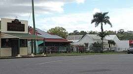 Rosedale, 2016 | |||||||||||||||
 Rosedale | |||||||||||||||
| Coordinates | 24°37′0″S 151°55′0″E | ||||||||||||||
| Population | 448 (2011 census)[1] | ||||||||||||||
| Postcode(s) | 4674 | ||||||||||||||
| Location | |||||||||||||||
| LGA(s) | |||||||||||||||
| State electorate(s) | |||||||||||||||
| Federal Division(s) | Flynn | ||||||||||||||
| |||||||||||||||
Geography
The town is 423 kilometres (263 mi) north of the state capital Brisbane and 58 kilometres (36 mi) north west of the regional centre of Bundaberg. The town is on the North Coast railway line.
Most of the locality is in the Gladstone Region but a small southern part on the shores of Lake Monduran is in the Bundaberg Region. Despite the town itself being in the Gladstone Region local government area, Rosedale is closer to Bundaberg than Gladstone. There has been some interest in the Rosedale community regarding breaking away from the Gladstone Region.[5]
In the east of the locality are the Littabella Conservation Park (which extends into neighbouring Watalgan) and the Littabella National Park (which extends into neighbouring Waterloo and Monduran). In the south-east of the locality is the Monduran State Forest which extends into neighbouring Monduran.[6]
History
In July 1853, John Little and his family made camp with their large herd of sheep overlanded from New South Wales and selected a site overlooking a large creek (now known as Baffle Creek). John Little's wife, Catherine, suggested the name "Rosedale" for the property and a vertical slab house "with barricades against the blacks" was constructed in 1854. The local Indigenous people resisted this occupation of their lands which resulted in several clashes. Lieutenant John Murray of the Native Police was called in on at least one occasion to forcibly remove Aboriginals from the area. This officer later married John Little's daughter, Rachel. These punitive missions resulted in numerous Aboriginal fatalities, in particular one now known as the Littabella massacre. After one raid, the Murray family adopted an Aboriginal child who was found in a hollow log.[7] On another occasion, the Littles themselves indiscriminately shot down "a large tribe of blacks..surprising them by discharging our firearms in the midst of them".[8] On 29 August 1863 John Little was struck by a falling limb from a burning tree and died the next day. A headstone marks the grave sites on the property. Rosedale Station remained in the Little family until approximately 1979.[9]
From the late 19th century, closer settlement of Rosedale began with selectors taking up subdivisions of land. The first school in Rosedale was built in 1895.[10]
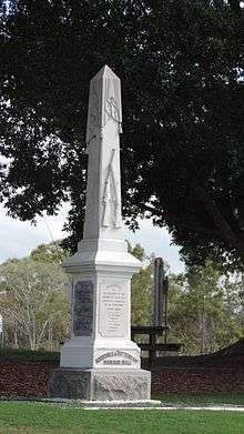
The Rosedale and Tottenham war memorial commemorating the fallen in World War I and World War II is located in James Street, beside the Memorial Hall.[11]
In 2004, a north-bound tilt train derailed injuring 120 passengers.[12]
At the 2011 census, Rosedale and the surrounding area had a population of 448.[1]
Education
The town also has a P–12 school catering for students from Rosedale, Lowmead, Agnes Water, 1770, Winfield and Yandaran.[13]
Amenities
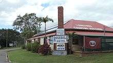
Facilities in the town include a pub, a tea house and a general store.[14]

St John's Community Church is privately owned and located in James Street.
The Rosedale cemetery is located north of the town in Ferry Road and is operated by the Gladstone Regional Council.
The Rosedale branch of the Queensland Country Women's Association meets at 13 McPherson Street.[15]
References
- Australian Bureau of Statistics (31 October 2012). "Rosedale (Qld)". 2011 Census QuickStats. Retrieved 5 November 2012.

- "Rosedale - town (entry 29045)". Queensland Place Names. Queensland Government. Retrieved 22 July 2016.
- "Rosedale - locality (Gladstone Region) (entry 47307)". Queensland Place Names. Queensland Government. Retrieved 22 July 2016.
- "Rosedale - locality (Bundaberg Region) (entry 44764)". Queensland Place Names. Queensland Government. Retrieved 22 July 2016.
- "Residents to be quizzed about breakaway plan". ABC News. Australian Broadcasting Corporation. 10 May 2012. Retrieved 4 November 2012.
- "Queensland Globe". State of Queensland. Retrieved 30 October 2018.
- "MRS. JOHN MURRAY". Morning Bulletin (20, 655). Queensland, Australia. 16 February 1931. p. 5. Retrieved 27 July 2018 – via National Library of Australia.
- "EARLY BUNDABERG". The Bundaberg Mail. 54 (8, 696). Queensland, Australia. 3 June 1924. p. 2. Retrieved 27 July 2018 – via National Library of Australia.
- Gladstone Local Heritage Register. "Rosedale Vertical Slab House". Retrieved 27 July 2018.
- "MURRAY'S CREEK, ROSEDALE". The Bundaberg Mail And Burnett Advertiser (1422). Queensland, Australia. 10 May 1895. p. 2. Retrieved 2 August 2018 – via National Library of Australia.
- "Rosedale and Tottenham War Memorial". Queensland War Memorial Register. Queensland Government. 23 June 2014. Retrieved 22 July 2016.
- Lion, Patrick; Hammond, Philip (27 November 2008). "Tilt Train crash another blow to Queensland Rail safety record". Courier Mail. Retrieved 5 November 2012.
- "Rosedale State School: P-12 Campus". The State of Queensland (Department of Education, Training and Employment). Retrieved 5 November 2012.
- "Rosedale". TotalTravel. Yahoo7. Retrieved 4 November 2012.
- "Branch Locations". Queensland Country Women's Association. Retrieved 26 December 2018.
External links
![]()