Rondônia
Rondônia (Brazilian Portuguese: [ʁõˈdõniɐ] (![]()
State of Rondônia Estado de Rondônia | |
|---|---|
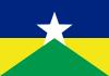 Flag  Coat of arms | |
| Anthem: Hino de Rondônia | |
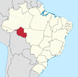 Location of State of Rondônia in Brazil | |
| Coordinates: 10.90°S 62.76°W | |
| Country | |
| Founded | September 13, 1943 |
| Capital and largest city | Porto Velho |
| Government | |
| • Governor | Coronel Marcos Rocha (PSL) |
| • Vice Governor | Zé Jodan (PSL) |
| • Senators | Acir Gurgacz (PDT) Confúcio Moura (MDB) Marcos Rogério (DEM) |
| Area | |
| • Total | 237,576.16 km2 (91,728.67 sq mi) |
| Area rank | 13th |
| Population (2010)[1] | |
| • Total | 1,562,409 |
| • Estimate (2019) | 1,777,225 |
| • Rank | 23rd |
| • Density | 6.6/km2 (17/sq mi) |
| • Density rank | 19th |
| Demonym(s) | Rondoniano or Rondoniense |
| GDP | |
| • Year | 2006 estimate |
| • Total | R$ 13,110,000,000 (22nd) |
| • Per capita | R$ 8,391 (15th) |
| HDI | |
| • Year | 2017 |
| • Category | 0.725[2] – high (19th) |
| Time zone | UTC-4 (BRT–1[3]) |
| Postal Code | 76800-000 to 76999-000 |
| ISO 3166 code | BR-RO |
| Website | rondonia.ro.gov.br |
Geography
Rondonia was originally home to over 200,000 km2 of rainforest, but has become one of the most deforested places in the Amazon. By 2003 around 70,000 km2 of rainforest had been cleared.[6]
The area around the Guaporé River is part of the Beni savanna ecoregion.[7]
The Samuel Dam is located in the state, on the Jamari River.[8]
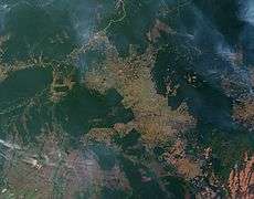 Slash-and-burn farming in the state of Rondônia.
 Madeira River and Porto Velho.
History
Demographics
According to the IBGE of 2008, there were 1,519,000 people residing in the state. The population density was 6.6 inhabitants/km2. Urbanization: 66.8% (2004); Population growth: 2.2% (1991-2000); Houses: 430,747 (2005).[9]
The last PNAD (National Research for Sample of Domiciles) census revealed the following numbers: 832,000 Brown (Multiracial) people (54.81%), 546,000 White people (35.95%), 115,000 Black people (7.56%), 16,000 Asian people (1.08%), 8,000 Amerindian people (0.53%).[10]
Native Brazilians

As of 2011 there were 21 Indigenous Territories in Rondônia, with two more in process of being demarcated.[11] The largest of these, the Uru-Eu-Wau-Wau Indigenous Territory, covers over 1.8 million hectares.[12] Another, the Rio Omerê Indigenous Territory, is home to the Kanoê and Akuntsu people, who number only four and five individuals respectively.[13][14]
Transport
Governador Jorge Teixeira de Oliveira International Airport is located in the state capital of Porto Velho.[15]
References
- Ibge.gov
- "Radar IDHM: evolução do IDHM e de seus índices componentes no período de 2012 a 2017" (PDF) (in Portuguese). PNUD Brasil. Retrieved 18 April 2019.
- "Flag Current Local Time in Porto Velho, Rondônia, Brazil". Time and Date. Retrieved 15 August 2016.
- In Brazilian Portuguese. The European Portuguese pronunciation is [ʁõˈdoniɐ].
- Revkin, Andrew (2004-09-30). The Burning Season: The Murder of Chico Mendes and the Fight for the Amazon Rain Forest. Island Press. p. 118. ISBN 9781610913485.
- "Amazon Deforestation". Earth Observatory. NASA. 2009-05-27. Retrieved 7 October 2012.
- Robin Sears and Robert Langstroth. "Central South America: Northern Bolivia". Tropical and Subtropical Grasslands, Savannas and Shrublands. WWF. Retrieved 7 October 2012.
- "Samuel Dam, Rondônia, Brazil". U.S. Geological Survey. 13 October 2011. Retrieved 26 January 2015.
- Source: PNAD.
- Tabela 262: População residente, por cor ou raça, situação e sexo (PDF) (in Portuguese). Rondônia, Brazil: IBGE. 2008. ISBN 978-85-240-3919-5. Retrieved 2010-01-18.
- "Terras Indígenas: Pesquisa por Estado: Rondônia". Povos Indígenas no Brasil (in Portuguese). Instituto Socioambiental (ISA). Retrieved 24 March 2011.
- "Caracterização Terra Indígena Uru-Eu-Wau-Wau". Povos Indígenas no Brasil (in Portuguese). Instituo Socioambiental (ISA). Retrieved 24 March 2011.
- Instituto Socioambiental (ISA). "Introduction > Akuntsu". Povos Indígenas no Brasil. Retrieved 8 March 2011.
- Instituto Socioambiental (ISA). "Introduction > Kanoê". Povos Indígenas no Brasil. Retrieved 8 March 2011.
- "Porto Velho, Belmonte (PVH) information". theAirDB. Retrieved 1 January 2013.
External links
- (in Portuguese) Official Website
- Rondonia Web
Capital: Porto Velho | ||
| Alvorada d'Oeste |  | |
| Ariquemes | ||
| Cacoal | ||
| Colorado do Oeste | ||
| Guajara-Mirim | ||
| Ji-Parana | ||
| Porto Velho | ||
| Vilhena | ||
| North | |
|---|---|
| Northeast | |
| Center-West | |
| Southeast | |
| South | |
| |
| Authority control |
|
|---|