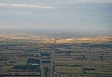
Rolleston, New Zealand
Rolleston /ˈrɒləstən/ (Māori: Roretana) is the seat and largest town in the Selwyn District, in the Canterbury region of New Zealand's South Island. It is located on the Canterbury Plains 22 kilometres (14 mi) south-west of Christchurch, and is considered a satellite town of the city. The town has a population of 16,350 (June 2019),[1] making it New Zealand's 32nd largest urban area.
Rolleston Roretana (Māori) | |
|---|---|
 Rolleston | |
| Coordinates: 43°35′S 172°23′E | |
| Country | |
| Island | South Island |
| Region | Canterbury |
| Territorial authority | Selwyn District |
| Named for | William Rolleston |
| Area | |
| • Total | 19.65 km2 (7.59 sq mi) |
| Elevation | 50 m (160 ft) |
| Population (June 2019)[1] | |
| • Total | 16,350 |
| • Density | 830/km2 (2,200/sq mi) |
| Time zone | UTC+12 (NZST) |
| • Summer (DST) | UTC+13 (NZDT) |
| Postcode(s) | 7614, 7615 |
| Local iwi | Ngāi Tahu |
History
Rolleston originated as a railway terminus in 1866, and is named after the Canterbury statesman William Rolleston. Rolleston, who was born in Yorkshire in 1831 and died in 1903, served as Superintendent of the Province of Canterbury from 1868 until 1876 (when central government abolished the New Zealand provinces). He also served as a Member of Parliament, holding various Cabinet portfolios.[2]
Selwyn District Council proposed an industrial subdivision, Izone, in 2000. The council purchased rural land adjacent to the Main South Line opposite the township of Rolleston, in the following year. The Warehouse Group has its South Island distribution centre at Izone.[3]
Demographics
| Historical population | ||
|---|---|---|
| Year | Pop. | ±% p.a. |
| 1996 | 1,520 | — |
| 2001 | 2,760 | +12.67% |
| 2006 | 5,150 | +13.29% |
| 2013 | 10,000 | +9.94% |
| 2018 | 16,250 | +10.20% |
| Source: Statistics NZ[1] | ||
Until 1990 the town had only a few sealed streets and a population of just under 1,000. The current expansion began in the 1990s. Rolleston had a population of 1,974 at the 2001 census, 3,822 at the 2006 census, and 9,555 at the 2013 census (note that census figures only count the Rolleston urban area as it was at the time).[4]
Surrounding area
The radiata pine plantations that were once a feature of this part of Canterbury have largely been replaced by more water-intensive grazing land to take advantage of the "dairy boom" of the early 21st century. Shelter belts of radiata, another significant earlier feature of the Plains (and very effective at mitigating the desiccating effects of the nor'west wind), have also been removed as they formed a barrier to the huge central-pivot irrigators that are now commonplace in the area. Rolleston is very exposed on the Canterbury Plains and is therefore slightly drier, with a more continental climate, than nearby Christchurch. There are many vineyards in the area.
Amenities
Rolleston Prison is located just west of the town, housing up to 260 minimum to medium security male prisoners.[5]
Rolleston is home to Pineglades Naturist Club, the South Island's largest naturist resort.[6][7]
Education
Rolleston has five full primary (year 1–8) schools:
- Clearview Primary School is a state school with a roll of approximately 695 students.[8] The school opened in February 2010.
- Lemonwood Grove School is a state school with a roll of approximately 400 students.[8] The school opened in February 2017.
- Rolleston School is a state school with a roll of approximately 762 students.[8] The school opened in 1893.
- Rolleston Christian School is a state-integrated nondenominational Christian school with a roll of approximately 149 students.[8] The school opened in February 2015.
- West Rolleston Primary School is a state school with a roll of approximately 593 students.[8] The school opened in February 2016.
Rolleston College is the sole secondary school in Rolleston, with a roll of approximately 956 students.[8]. It opened on 30 January 2017, and as of 2020 is only open to Year 9–12 students, with other year levels added as students move through.[9] Students in Year 13 are currently served by Lincoln High School, 12 km away in the nearby town of Lincoln.
Transport
State Highway 1 passes through Rolleston on its route between Christchurch and Timaru. In August 2016, construction began to extend the Christchurch Southern Motorway from its current terminus at Hornby to just east of Rolleston. This motorway will open to traffic in 2020[10]
Two local bus routes serve Rolleston, both being part of Environment Canterbury's Metro system: the Yellow Line route connects Rolleston with central Christchurch, Linwood, and New Brighton via Templeton, Hornby and Riccarton,[11] while route 820 (Burnham to Lincoln) connects Rolleston to the nearby towns of Burnham and Lincoln.[12]
Rolleston is the site of the railway junction between the Midland line to Greymouth and the Main South Line. The town served as a major railway junction point from the 1880s until the late 1980s, when the New Zealand government deregulated the railways, and Rolleston became a stop only for the tourist-oriented TranzAlpine rail service. As of 2010, passengers wanting to board the TranzAlpine at Rolleston must specify this when booking. In 1993 Rolleston saw one of the country's worst level-crossing accidents, when a cement mixer truck ran into the side of a passenger train at the now-closed George Holmes Road level crossing and killed 3 train passengers.[13]
Christchurch earthquakes
Rolleston was close to the epicentre of the 2010 Canterbury earthquake being near the end of the Greendale Fault, experiencing movement two times the strength of that in Christchurch City. Residents were without power following the quake, some for more than 48 hours, and were required to boil water for weeks before services were restored. Rolleston was close to many of the aftershocks following the September quake.
Rolleston suffered low damage due the ground having underlying stones and stable rock. For such reasons, Rolleston has not been affected by liquefaction to date, and only a few houses have been condemned and demolished from earthquake damage.[14]
The 2011 Christchurch earthquake caused a minor amount of extra damage, mostly to buildings which had already been previously affected.
The population of Rolleston has expanded rapidly since the Christchurch earthquakes due to the land stability and fast tracking of building consents by the Selwyn District Council.[15]
References
- "Subnational Population Estimates: At 30 June 2019". Statistics New Zealand. 22 October 2019. Retrieved 11 January 2020.
- Gardner, Jim. "Rolleston, William". Dictionary of New Zealand Biography. Ministry for Culture and Heritage. Retrieved 31 July 2011.
- "Selwyn's Izone growing". The Press. 18 August 2010. Retrieved 3 July 2019.
- "Selwyn's Izone growing". The Press. Christchurch: Fairfax New Zealand. 18 August 2010. Retrieved 20 October 2010.
February 2003: Plan change allows for Rolleston's population to grow from 3000 to 14,000.
- "Rolleston Prison". Department of Corrections. Retrieved 25 May 2014.
- "Pineglades Naturist Club". gonatural.co.nz. New Zealand Naturist Federation. Retrieved 24 November 2019.
- "Naturists and Nudists Clubs on New Zealand's South Island". TripSavvy. Dotdash. Retrieved 24 November 2019.
- "New Zealand Schools Directory". New Zealand Ministry of Education. Retrieved 26 April 2020.
- Parata, Hekia (3 March 2014). "Minister announces establishment of new schools for Rolleston". New Zealand Government. Retrieved 20 April 2014.
- "Christchurch Southern Motorway – Stage 2". NZ Transport Agency. Retrieved 4 February 2017.
- "Route Y map". Metro Canterbury. Retrieved 12 June 2016.
- "820 Burnham to Lincoln map". Metro Canterbury. Retrieved 12 June 2016.
- "Concrete truck in near-miss with TranzAlpine express". The New Zealand Herald. 27 May 2008. Retrieved 11 August 2010.
A collision between a concrete truck and the Southerner passenger train at Rolleston in 1993 cost the lives of three passengers [...]
- "Rolleston Suburb Damage". Rebuild Christchurch Foundation. Retrieved 7 August 2012.
- "Growth towns in NZ: The rise of Rolleston". Noted. 7 September 2018. Retrieved 22 November 2019.