Roker
Roker (/ˈroʊkər/) is a tourist resort and affluent area of Sunderland, North East England, bounded on the south by the River Wear and Monkwearmouth, on the east by the North Sea, to the west by Fulwell and on the north by Seaburn. It is administered as part of the City of Sunderland.
| Roker | |
|---|---|
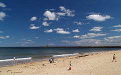 Roker beach | |
 Roker Location within Tyne and Wear | |
| Population | 4,600 |
| OS grid reference | NZ405595 |
| Metropolitan borough | |
| Metropolitan county | |
| Region | |
| Country | England |
| Sovereign state | United Kingdom |
| Post town | SUNDERLAND |
| Postcode district | SR6 |
| Dialling code | 0191 |
| Police | Northumbria |
| Fire | Tyne and Wear |
| Ambulance | North East |
| UK Parliament |
|
The majority of the houses in Roker are terraced or semi-detached. Further west, to the part bordering Fulwell, are cul-de-sacs with semi-detached bungalows, these being owned mainly by members of Roker's sizeable elderly population. On Roker Terrace (Roker's main street) are exclusive apartments and hotels which overlook the seafront.
In addition to Seaburn seafront, the coast at Roker seafront plays host to Sunderland International Airshow, the biggest free airshow in Europe, which takes place each year, usually over the last weekend in July.
History

The story of Roker begins in 1587, when the Abbs family were granted land on the north side of the River Wear on the condition that they provided six soldiers to defend the mouth of the river. Fast forward to 1840, when Roker Terrace was built upon the cliff tops, along with Monkwearmouth baths and Roker Park soon after. The pier and lower promenade were built six years later. In 1898 Roker Park Stadium was built and Roker became known worldwide for being home to Sunderland A.F.C.. The stadium was used for ninety-nine years until 1997. In the early 20th century Roker became a hugely popular resort for locals and tourists alike, and in 1928 it was taken over by the Borough of Sunderland, along with Fulwell and Seaburn.
Steven Grieveson, the Sunderland Strangler operated in Roker.

In 1995 Roker Park Conservation Area was declared.[1]
Landmarks
St Andrew's Church (1905–07) is recognised as one of the finest churches of the first half of the twentieth century and the masterpiece of Edward Schroeder Prior.
One well-known landmark of sorts in Roker is the Bungalow Cafe, which is an old-fashioned café in a tiny bungalow on the upper promenade. Also famous is the signpost next to the café, marked: "To Beach" (pointing towards the beach), "To Village" (pointing into Roker), "To Bungalow" (pointing to the cafe), and "To Germany" (pointing out to sea).
A museum is located in the Roker Watch House which was originally opened in 1906 as the headquarters of the Roker Volunteer Life Brigade. It is open every Sunday afternoon and on Bank Holiday Mondays.[2]
Other nearby landmarks are the statue of Bede's cross on the cliff top near Roker Park and St Peter's Church, Monkwearmouth. The cross recognises the work of the Venerable Bede, who worked in the North-East all his life at the twin monasteries of Wearmouth and Jarrow. There is bid for the twin monasteries to gain World Heritage Site status.
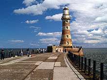
Lighthouses and pier
 | |

| |
| Location | City of Sunderland, United Kingdom |
|---|---|
| Coordinates | 54.921263°N 1.352550°W |
| Year first constructed | 1903 |
| Construction | white and red granite tower |
| Tower shape | tapered cylindrical tower with balcony and lantern |
| Markings / pattern | white and red band tower, white lanren, black lantern roof |
| Tower height | 23 metres (75 ft) |
| Focal height | 25 metres (82 ft) |
| Original lens | 3rd order rotating catadioptric |
| Current lens | rotating LED |
| Range | 23 nmi (43 km; 26 mi) |
| Characteristic | Fl W 20s. |
| Fog signal | 1 blast every 20s. |
| Admiralty number | A2681 |
| NGA number | 2084 |
| ARLHS number | ENG-116 |
| Managing agent | Port of Sunderland[3] |
| Heritage | Grade II listed |
From 1717 the newly formed River Wear Commission began to improve the harbour entrance at the mouth of the Wear. By 1750 a pair of breakwaters had been built (which survive in truncated form as the 'Old' North and South Piers).
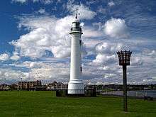
By the beginning of the next century each had a lighthouse at its end. (The lighthouse which stands today in Roker Cliff Park originally stood on the Old South Pier; it was deactivated in 1903 and removed eighty years later.)[4]
With the growth of Sunderland as a port, it was decided to improve the approach to the river by creating an outer harbour, protected by a new pair of new breakwaters curving out into the North Sea from the shore on each side. The new piers were the brainchild of Henry Hay Wake, who at the age of 25 had been appointed Chief Engineer to the River Wear Commission (in succession to Thomas Meik) in 1868.[5] The foundation stone for the New North Pier (Roker Pier) was laid on 14 September 1885. Applauded at the time as a triumph of engineering, the 2,000 ft (610 m) pier is built of granite-faced concrete blocks, which were manoeuvred into place by a gas-powered crane nicknamed 'Goliath'.
The lighthouse at the pier head was completed in 1903. Its distinctive stripes are of naturally coloured red and white Aberdeen granite. When built it was said to be Britain's most powerful port lighthouse. It was lit by a Chance Brothers incandescent petroleum vapour mantle lamp set within a third-order rotating catadioptric optic (consisting of a single-panel Fresnel lens backed by a prismatic mirror); it displayed a single flash every five seconds.[6] In 1972 the light was automated and a set of sealed beam units replaced the old optic; these were themselves replaced with a dual-drive Pelangi PRL400 rotating pedestal and lamp in 2007.[7]
The opposite 'New South Pier' was begun at around the same time but never fully completed due to the start of the First World War; the twin lighthouse planned for its end was never built.
Roker Pier Lighthouse still functions today. Both pier and lighthouse have undergone significant refurbishment in recent years.[8] In 2012, as part of the restoration, a new revolving LED lamp array was installed, replacing the small Pelangi unit previously in use.[7] In 2018, following a comprehensive six-year process of refurbishment, the lighthouse was opened to the public for the first time; regular guided tours now take place, with access provided by way of the tunnel which runs the length of the pier.[9]
Demographics
The population of Roker is approximately 4,600. Since the redevelopment of former brownfield areas of heavy industry into affluent riverside housing areas, and the founding of the St Peters Campus of the University of Sunderland to the immediate south of the area, Roker has undergone rapid demographic change. The first of these two changes brought a large influx of professional and managerial workers into the areas now known as St Peters Riverside and North Haven. The arrival of the university campus has seen a large number of the larger houses in the vicinity of Roker Avenue being converted into flats and student residences. The pursuant studentification has brought a substantial Chinese community into the area for the first time, along with a variety of other nationalities
Along with the district of Monkwearmouth, Roker forms the St Peter's electoral ward on Sunderland City Council, which is a division of the Sunderland Central parliamentary seat. St Peter's ward was a safe Conservative ward in the 1980s, but became a battleground between the Conservatives and Labour in the 1990s and has remained as such ever since.[10] Of the wards three council seats, Labour currently hold two and the Conservatives hold one.
Trivia
On the site of Sunderland AFC's former stadium is a small housing estate, its street names all being references to the football club (Clockstand Close, Goalmouth Close, etc.). The streets in between Roker Baths Road and Roker Avenue are all named after members of William Ewart Gladstone's cabinet (Gladstone, Hartington, Forster, Bright, Stansfield, and so on).
References
- "Sunderland City Council". Retrieved 16 September 2016.
- Suggitt, Paul. "Sunderland Volunteer Life Brigade - Saving Lives Since 1877". Archived from the original on 23 September 2016. Retrieved 16 September 2016.
- Roker Pier (Sunderland North Pier) The Lighthouse Directory. University of North Carolina at Chapel Hill. Retrieved 5 May 2016
- Jones, Robin (2014). Lighthouses of the North East Coast. Wellington, Somerset: Halsgrove.
- "Historical Timeline". Roker Pier. Retrieved 23 March 2019.
- Encyclopaedia Britannica vol. 16 p.672
- Jones, Robin (2014). Lighthouses of the North East Coast. Wellington, Somerset: Halsgrove. pp. 74–81. ISBN 978 0 85704 234 7.
- "Northern Archaeological Associates".
- "Welcome to Roker Pier". Roker Pier. Retrieved 23 March 2019.
- Rallings, Colin (2012). "Sunderland City Council Election Results, 1973-2012" (PDF). Retrieved 9 April 2017.
External links
| Wikimedia Commons has media related to Roker. |
- Roker Pier
- BBC Wear – Take a tour of Roker Beach
- BBC Wear – Pictures: Walk from Roker to Seaburn
- 360° view of the Roker seafront
- St Peter's Church, Monkwearmouth