Byker
Byker is an inner city electoral ward in the city of Newcastle upon Tyne in Tyne and Wear, England. It is in the east of the city, south of the Heaton area and north of St Peter's. Byker Metro station serves the area. The area also contains the Byker Wall estate. The population of the ward is 11,339, increasing to 12,206 at the 2011 Census,[1] which is 4.4% of the city's total. Car ownership stands at 35.4%,[2] much lower than the city average of 54.7%.
| Byker | |
|---|---|
 Shields Road, Byker | |
 Byker Location within Tyne and Wear | |
| OS grid reference | NZ279637 |
| • London | 242 miles (389 km) |
| Metropolitan borough | |
| Metropolitan county | |
| Region | |
| Country | England |
| Sovereign state | United Kingdom |
| Post town | NEWCASTLE UPON TYNE |
| Postcode district | NE6 |
| Dialling code | 0191 |
| Police | Northumbria |
| Fire | Tyne and Wear |
| Ambulance | North East |
| UK Parliament | |
Byker has suffered the kinds of the social problems common to other inner-city urban housing areas, including juvenile crime and vandalism. In parts of Byker turnover of tenancies has been high. Families have moved away - particularly those in employment. Some shops and services have been abandoned and boarded up. In the mid-1990s it was estimated one in three of Byker's adult inhabitants was unemployed.
Byker is well known as the setting of the former BBC TV series Byker Grove and although set in the ward, the youth club featured in the series was filmed at The Mitre in the Benwell area in the west end of Newcastle.
History
Possibly the earliest form of the visible evidence of development in Byker was by the Roman Emperor, Hadrian. A wall, turrets and mile castles, stretching from the east to the west coast provided a barrier to invading border clans and tribes. Hadrian’s Wall lies just south of Shields Road and was excavated in the 1990s. The area was populated by soldiers and their suppliers of foods, livestock and trades, such as weavers, saddlers and blacksmiths amongst others. There are the remains of a mile castle or small fort near Brough Park dog track.[3]
Byker first appeared in historical documents in 1198 ‘as the most important Serjeantry in Northumberland’ held by William of Byker, named William Escolland, who was a Norman noble.[3] In 1549 the Mayor and Burgesses of Newcastle sought to extend the town's boundaries to include part of Byker Township, to take advantage of the land by the river ‘for the dropping of ballast for the coal trade’. The transaction was disputed due to financial disagreements and eventually settled in the House of Commons and the House of Lords in London.
Development
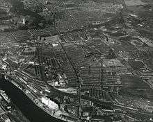
Until the 1960s, Byker was a Victorian working-class area of densely built terraces. Much of the housing needed major repair and some was considered unfit for human habitation (many houses lacked bathrooms),[4] yet most residents wanted to stay in Byker, an area close to industry on the riverside. In 1966 Newcastle City Corporation took the decision to redevelop the Byker area. The council aimed to clear the slums but keep the community.
Byker was extensively photographed before its demolition, primarily by Sirkka-Liisa Konttinen,[5] who lived in Byker from 1969.[6] The photographs that Konttinen took toured China in 1980 and later appeared in the book Byker.[7]
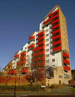
Ralph Erskine was appointed as the architect in 1969 for the new Byker.[8] The development was run as a "rolling programme" so local people could continue living in the area during the building work. Residents were involved in the design process and it is thought the outstanding success[9] of Byker was as much to do with this as its innovative architecture which used a Functionalist Romantic style, differentiating the Estate from the Brutalist approach which was more common at the time.[10]
New leisure and shopping facilities have been brought to the Shields Road area, while community led initiatives have encouraged the growth of local enterprise and enriched the social fabric of the estate. Byker and the Ouseburn area to the south have seen investment in recent years, becoming a cultural hub for the city. Byker Estate itself received a Grade II* listing in 2007 due to its architectural significance, and has since undergone a £25million regeneration with a further £4m of environmental upgrades to the area taking place in 2020.
In 2017 the Byker Wall estate was named as the best neighbourhood in the UK by the Academy of Urbanism's 'The Great Neighbourhood' award.[11]
Education
The ward has three primary schools, St. Lawrence RC Primary School,[12] Welbeck Academy and Byker Primary School, which is equipped with a nursery class.[13] The ward does not have any secondary schools, the nearest secondary schools are Heaton Manor School, Walker Technology College and Benfield School. Byker Primary School was rated 'Outstanding' in its most recent Ofsted report.
Recreation and leisure
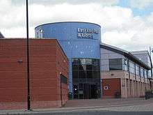
Most of these facilities are in the bordering ward of South Heaton such as the East End Pool & Library on Corbridge Street. In March 2019 it was announced that the library would be transferred to the Shields Road Customer Service Centre in May 2019.[14] The ward itself is at Garden City standards in terms of housing density, offering a number of well-maintained green open spaces. The ward hosts the 'Byker in Bloom' gardening competition which takes place in every summer, including a number of different categories including 'Best Balcony' and 'Best Newcomer'. In 2008, Newcastle City Council agreed a lease of the former Byker Swimming Pool on Shipley Place which had remained closed and unused since the late 1990s, allowing it to be converted into an indoor bouldering and climbing centre known as 'Climb Newcastle'.[15]
Transport
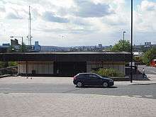
Byker is served by Byker Metro station on the Tyne and Wear Metro and Shields Road is served by numerous bus routes.
Boundary
Byker ward stretches from the Fossway and Millers Road in the north of the ward to the banks of the River Tyne in the south. It heads south onto the Shields Road bypass (A187) and continues along the A193 bypass along Shields Road to the Ouse Burn. It turns south down the Ouse Burn to the River Tyne and follows the river east, turning northwards to the west of the properties on The Oval (and excluding the Bakewell Terrace properties). Heading east along Walker Road, the boundary then turns north up Monkchester Road and continues north. It turns west along Dunstanburgh Road, and then north between Welbeck Primary School grounds and the properties on Allendale Road. It turns east along Welbeck Road, then north up Scrogg Road, east at Middle Street, and north along Langley Road. The boundary then runs along the gardens at the back of Whinneyfield Road before turning west down the Fossway.
Demographic characteristics
The results of the UK Census taken on 27 March 2011 for the Byker Ward show the total population on Census night was 12,206 people in 5,835 households.[16] [17]
| Age group | Percentage |
|---|---|
| Under 15 | 19.0% |
| 15-24 | 14.5% |
| 25-64 | 54.0% |
| 65+ | 12.5% |
A quarter of people in the Byker ward have a long-term health problem or disability which affects day-to-day activities (25.0%).[16] Lone parent households with dependent children accounted for 12.3% of all households, which is higher than the city average of 7.6%.[16]
Notes
- "Newcastle-upon-Tyne ward population 2011". Retrieved 5 July 2011.
- http://www.newcastle.gov.uk/your-council/statistics-and-census-information/byker-2001-census
- "Timeline - Byker Lives".
- "Archived copy". Archived from the original on 7 February 2015. Retrieved 6 February 2015.CS1 maint: archived copy as title (link)
- David Alan Mellor, No Such Thing as Society: Photography in Britain 1967–1987: From the British Council and the Arts Council Collection (London: Hayward Publishing, 2007; ISBN 978-1-85332-265-5), p.84.
- "Sirkka-Liisa Konttinen", Amber Online. Accessed 2010-02-19.
- "People of the Hills - Amber Collection".
- Rowntree, Diana (22 March 2005). "Obituary: Ralph Erskine" – via www.theguardian.com.
- "Ralph Erskine". The Daily Telegraph. London. 18 March 2005.
- BBC. "How We Built Britain".
- https://www.chroniclelive.co.uk/news/north-east-news/byker-wall-named-best-neighbourhood-13881931
- "St. Lawrence's RC Primary School - Newcastle City Council". www.newcastle.gov.uk.
- "Byker Primary School - Newcastle City Council". www.newcastle.gov.uk.
- Holland, Daniel (11 March 2019). "Newcastle East End Library to move in May as residents fear drop in visitors". nechronicle.
- "Climb Newcastle - Adventure Sport Centre in Newcastle upon Tyne, Newcastle upon Tyne - NewcastleGateshead". www.newcastlegateshead.com.
- Technology, Origin - Fluent. "Ward Profiles - Know Newcastle". www.knownewcastle.org.uk. Retrieved 23 March 2018.
- Services, Good Stuff IT. "Byker - UK Census Data 2011". UK Census Data. Retrieved 23 March 2018.
External links
- Photos of the area from Geograph
- Know Newcastle ward profile
- Byker UK Census data 2011
- Kay's Geography guide to the Byker estate including photos and current issues
- Newcastle council 2001 census (archived page)
- Ouseburn Valley regeneration project (archived page)
- Newcastle Council Ward Info: Byker (archived page)
Further reading
- Konttinen, Sirkka-Liisa. Byker. London: Jonathan Cape, 1983. ISBN 0-224-02109-5. Newcastle: Bloodaxe Books, 1985. ISBN 0-906427-90-8.
- Konttinen, Sirkka-Liisa. Byker Revisited. Newcastle upon Tyne: Northumberland University Press, 2009. ISBN 978-1-904794-42-4.
External links
![]()