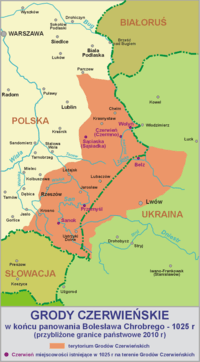
Red Ruthenia
Red Ruthenia or Red Rus' (Latin: Ruthenia Rubra; Russia Rubra; Ukrainian: Червона Русь, romanized: Chervona Rus'; Polish: Ruś Czerwona, Ruś Halicka; Russian: Червонная Русь, romanized: Chervonnaya Rus') is a term used since the Middle Ages for the south-western principalities of the Kievan Rus', namely the Principality of Peremyshl and the Principality of Belz. Nowadays the region comprises parts of western Ukraine and adjoining parts of south-eastern Poland. It has also sometimes included parts of Lesser Poland, Podolia, "Right-bank Ukraine" and Volhynia. Centred on Przemyśl (Peremyshl) and Belz, it has included major cities such as: Chełm, Zamość, Rzeszów, Krosno and Sanok (now all in Poland), as well as Lviv and Ternopil (in Ukraine).
Red Ruthenia | |
|---|---|
Historic Region | |
 The western part of Red Ruthenia (without Podolia) superimposed on contemporary borders | |
| Region | Central and Eastern Europe (parts of southeast Poland and western Ukraine) |
.jpg)
First mentioned by that name in a Polish chronicle of 1321, Red Ruthenia was the portion of Ruthenia incorporated into Poland by Casimir the Great during the 14th century. The disintegration of Rus', Red Ruthenia was contested by the Grand Duchy of Lithuania (the Gediminids), the Kingdom of Poland (the Piasts), the Kingdom of Hungary and the Kingdom of Ruthenia. After the Galicia–Volhynia Wars, for about 400 years most of Red Ruthenia became part of Poland as the Ruthenian Voivodeship.
A minority of ethnic Poles have lived since the beginning of the second Millennium in northern parts of Red Ruthenia. The exonym "Ruthenians" usually refers to members of the Rusyn and/or Ukrainian ethnicity.[1]
History
Ethnography
_..jpg)
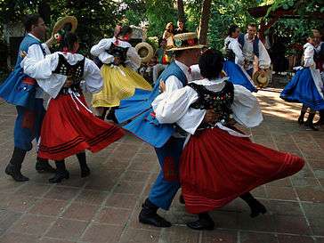
The first known inhabitants of northern Red Ruthenia were Lendians,[2] while subgroups of Rusyns, such as Boykos and Lemkos, lived in the south.
Later Walddeutsche ("Forest Germans"), Jews, Armenians and Poles also made up part of the population.[3] According to Marcin Bielski, although Bolesław I Chrobry settled Germans in the region to defend the borders against Hungary and Kievan Rus' the settlers became farmers. Maciej Stryjkowski described German peasants near Rzeszów, Przemyśl, Sanok, and Jarosław as good farmers. Casimir the Great settled German citizens on the borders of Lesser Poland and Red Ruthenia to join the acquired territory with the rest of his kingdom. In determining the population of late medieval Poland, colonisation and Polish migration to Red Ruthenia, Spiš and Podlachia[4] (whom the Ukrainians called Mazury—poor peasant migrants, chiefly from Mazowsze[5]) should be considered.
During the second half of the 14th century, the Vlachs arrived from the southeastern Carpathians and quickly settled across southern Red Ruthenia. Although during the 15th century the Ruthenians gained a foothold, it was not until the 16th century that the Wallachian population in the Bieszczady Mountains and the Lower Beskids was Ruthenized.[6] From the 14th to the 16th centuries Red Ruthenia underwent rapid urbanization, resulting in over 200 new towns built on the German model (virtually unknown before 1340, when Red Ruthenia was the independent Duchy of Halych).[7]
Political history
1199 to 1772
During the early Middle Ages, the region was part of Kievan Rus' and, from 1199, the independent Kingdom of Galicia–Volhynia.
It came under Polish control in 1340, when Casimir the Great acquired it.[9][10] During his reign from 1333 to 1370, Casimir the Great founded several cities, urbanizing the rural province.[11]
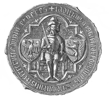
The Polish name Ruś Czerwona (translated as "Red Ruthenia") came into use for the territory extending to the Dniester, centring on Przemyśl (Peremyshl). Since the reign of Władysław Jagiełło (d. 1434) the Przemyśl Voivodeship was called the Ruthenian Voivodeship (województwo ruskie), centring on Lwów. The voivodeship consisted of five regions: Lwów, Sanok, Halicz (Halych), Przemyśl (Peremyshl), and Chełm. The town of Halych gave its name to Galicia.During the 1340s, the influence of the Rurik dynasty ended; most of the area passed to Casimir the Great, with Kyiv and the state of Volhynia falling under the control of the Grand Duchy of Lithuania. The Polish region was divided into a number of voivodeships, and an era of German eastward migration and Polish settlement among the Ruthenians began. Armenians and Jews also migrated to the region. A number of castles were built at this time, and the cities of Stanisławów (Stanyslaviv in Ukrainian, now Ivano-Frankivsk) and Krystynopol (now Chervonohrad) were founded.
In October 1372, Władysław Opolczyk was deposed as count palatine. Although he retained most of his castles and goods in Hungary, his political influence waned. As compensation, Opolczyk was made governor of Hungarian Galicia. In this new position, he contributed to the economic development of the territories entrusted to him. Although Opolczyk primarily resided in Lwów, at the end of his rule he spent more time in Halicz. The only serious conflict during his time as governor involved his approach to the Orthodox Church, which angered the local Catholic boyars. Under Polish rule 325 towns were founded from the 14th century to the second half of the 17th century, most during the 15th and 16th centuries (96 and 153, respectively).[12]
Ruthenia was subject to repeated Tatar and Ottoman Empire incursions during the 16th and 17th centuries and was impacted by the Khmelnytsky Uprising (1648–1654), the 1654–1667 Russo-Polish War and Swedish invasions during the Deluge (1655–1660); the Swedes returned during the Great Northern War of the early 18th century. Red Ruthenia consisted of three voivodeships: Ruthenia, whose capital was Lviv and provinces were Lviv, Halych, Sanok, Przemyśl and Chełm; Bełz, separating the provinces of Lviv and Przemyśl from the rest of the Ruthenian voivodeship; and Podolia, with its capital at Kamieniec Podolski.
- Ruthenian Voivodeship
- Chełm Land (Ziemia Chełmska), Chełm
- Chełm County, (Powiat Chełmski), Chełm
- Powiat of Ratno, (Powiat Ratneński), Ratno
- Halych Land (Ziemia Halicka), Halicz
- Lwów Land (Ziemia Lwowska), Lwów
- Powiat of Lwów, (Powiat Lwowski), Lwów
- Powiat of Żydaczów, (Powiat Żydaczowski), Żydaczów* Przemyśl Land (Ziemia Przemyska), Przemyśl; Its area was 12,000 km2. and in the 17th century it was divided five smaller regions (county, powiaty).
- Przemyśl County (Powiat Przemyski), Przemyśl
- Powiat of Sambor, (Powiat Samborski), Sambor
- Powiat of Drohobycz, (Powiat Drohobycki), Drohobycz
- Powiat of Stryj, (Powiat Stryjski), Stryj
- Sanok Land (Ziemia Sanocka), Sanok
- Sanok County (Powiat Sanocki), Sanok: Intensive settlement occurred from the 13th to 15th centuries in an area flanked by the Wisłok, San and Wisłoka Rivers. The Vlachs primarily engaged in agriculture; moving west, they established a number of villages during the 15th century. In Sanok Land were six Jewish communities, with synagogues and kahal organizations. Sixteenth- and seventeenth-century Jewish Communities were also autonomous in criminal law.


- Bełz Voivodeship
1772 to 1918
Red Ruthenia (except for Podolia) was conquered by the Austrian Empire in 1772 during the First Partition of Poland, remaining part of the empire until 1918.[14] Between World Wars I and II, it belonged to the Second Polish Republic. The region is currently split, with its western portion in southeastern Poland (around Rzeszów, Przemyśl, Zamość and Chełm) and its eastern portion (around Lviv) in western Ukraine.
See also
| Wikimedia Commons has media related to Red Ruthenia. |
Sources
- "Monumenta Poloniae Historica"
- Akta grodzkie i ziemskie z archiwum ziemskiego. Lauda sejmikowe. Tom XXIII, XXIV, XXV.
- Słownik geograficzny Królestwa Polskiego (Digital edition)
- Lustracja województwa ruskiego, podolskiego i bełskiego, 1564-1565 Warszawa, (I) edition 2001, pages 289. ISBN 83-7181-193-4
- Lustracje dóbr królewskich XVI-XVIII wieku. Lustracja województwa ruskiego 1661—1665. Część III ziemie halicka i chełmska. Polska Akademia Nauk - Instytut Historii. 1976
- Lustracje województw ruskiego, podolskiego i bełskiego 1564 - 1565, wyd. K. Chłapowski, H. Żytkowicz, cz. 1, Warszawa - Łódź 1992
- Lustracja województwa ruskiego 1661-1665, cz. 1: Ziemia przemyska i sanocka, wyd. K. Arłamowski i W. Kaput, Wrocław-Warszawa-Kraków. 1970
- Aleksander Jabłonowski. Polska wieku XVI, t. VII, Ruś Czerwona, Warszawa 1901 i 1903.
References
- "The dominant population of Galicia, or Red Rus', called itself “Rusyn” ... and was considered by Russophile authors to be Russian, or, more specifically, Little Russian. That view began to gain ground after the publication in the Russian Empire of a Russian translation of Pavol Šafárik's Slovanský národopis in 1843." (Serhii Plokhy, Lost Kingdom: The Quest for Empire and the Making of the Russian Nation, New York, Hachette, p. 168.
- Andrzej Rozwałka (2008). "Pobuże region as an object of research and protection of the archaeological heritage from the period of Early Middle Ages". In Maciej St. Zięba (ed.). Our Bug. Creating conditions for development of the border areas of Poland, Ukraine and Belarus through enhancement and preservation of natural and cultural heritage (PDF). John Paul II Catholic University of Lublin. p. 109.
The cultural unity of the area had been disturbed, if we look at it from the perspective of the whole Lesser Poland, after the basin of upper and middle Bug and of upper Wieprz rivers had been taken over in 981 (or 979) by Ruthenia, with its rich culture of urban character, the fact that can be seen in such places as Czermno, Chełm, or Gródek on Bug . This way a new boundary had divided the former community of Lendians living in the basins of rivers San, upper Bug, Styr and probably upper Dniester, who subsequently were absorbed in majority by the eastern Slavic element.
Archive index at the Wayback Machine - "were mainly Germans, Poles, Armenians and Jews, but also Karaims, Crimean Tatars, Greeks or Wallachians [in:] "Kwartalnik historii kultury materialnej: t. 47, PAN. 1999. p. 146
- Vierteljahrschrift für Sozial- und Wirtschaftsgeschichte, 1992
- M. H. Marunchak. The Ukrainian Canadians, 1982
- Czajkowski, 1992; Parczewski, 1992; Reinfuss, 1948, 1987, 1990
- Kwartalnik historii kultury materialnej: t. 47, PAN. 1999. p. 146
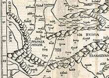
- „Karte von Germania, Kleinpolen, Hungary, Walachai u. Siebenbuergen nebst Theilen der angraenzenden Laender“ von des „Claudii Ptolemaei geographicae enarrationis libri octo“, 1525, Strassburg
- H. H. Fisher, "America and the New Poland (1928)", Read Books, 2007, p. 15
- N. Davies, God's playground: a history of Poland in two volumes, Oxford University Press, 2005, pp. 71, 135
- Anna Beredecka, NOWE LOKACJE MIAST KRÓLEWSKICH W MAŁOPOLSCE W LATACH 1333–1370
- A. Janeczek, Town and country in the Polish Commonwealth, 1350-1650, in: S. R. Epstein, Town and Country in Europe, 1300-1800, Cambridge University Press, 2004, p. 164
- Franciszek Kotula. Pochodzenie domów przysłupowych w Rzeszowskiem. "Kwartalnik Historii Kultury Materialnej" Jahr. V., Nr. 3/4, 1957, S. 557
- K. Kocsis, E. K. Hodosi, Ethnic Geography of the Hungarian Minorities in the Carpathian Basin, Simon Publications, 1988, p. 84