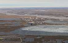
Prudhoe Bay, Alaska
Prudhoe Bay /ˈpruːdoʊ/ or Sagavanirktok is a census-designated place (CDP) located in North Slope Borough in the U.S. state of Alaska. As of the 2010 census, the population of the CDP was 2,174 people, up from just 5 residents in 2000; however, at any given time, several thousand transient workers support the Prudhoe Bay oil field. The airport, lodging, and general store are located at Deadhorse; the rigs and processing facilities are located on scattered gravel pads laid atop the tundra. It is only during winter that the surface is hard enough to support heavy equipment, and new construction happens at that time.
Prudhoe Bay, Alaska Sagavanirktok | |
|---|---|
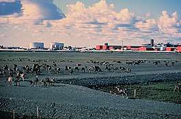 Caribou walk across a gravel pad at Kuparuk, 45 miles away from Prudhoe Bay, with oilfield facilities in the background. | |
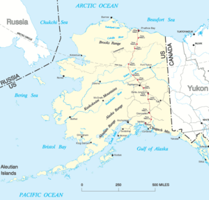
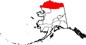 Location in North Slope Borough and the state of Alaska | |
 Prudhoe Bay, Alaska Location in the United States of America | |
| Coordinates: 70°19′32″N 148°42′41″W | |
| Country | United States |
| State | Alaska |
| Borough | North Slope |
| Government | |
| • Borough mayor | Harry K. Brower, Jr. |
| • State senator | Donny Olson (D) |
| • State rep. | John Lincoln (D) |
| Area | |
| • Total | 558.0 sq mi (1,445.3 km2) |
| • Land | 416.3 sq mi (1,078.1 km2) |
| • Water | 141.8 sq mi (367.2 km2) |
| Elevation | 30 ft (9 m) |
| Population (2010) | |
| • Total | 2,174 |
| • Density | 3.9/sq mi (1.5/km2) |
| Time zone | UTC-9 (Alaska (AKST)) |
| • Summer (DST) | UTC-8 (AKDT) |
| ZIP code | 99734 |
| Area code(s) | 907 (Local exchange prefix: 659) |
| FIPS code | 02-64380 |
| GNIS feature ID | 1865563 |
Prudhoe Bay is the unofficial northern terminus of the Pan-American Highway. The Bay itself is still 10 miles further north through a security checkpoint so open water is not visible from the highway. A few tourists, arriving by bus after a two-day ride up the Dalton Highway from Fairbanks, come to see the tundra, the Arctic Ocean, and the midnight sun, staying in lodgings assembled from modular buildings. Tours must be arranged in advance to see the Arctic Ocean and the Bay itself.
Prudhoe Bay was named in 1826 by British explorer Sir John Franklin after his classmate Captain Algernon Percy, Baron Prudhoe. Franklin traveled westerly along the coast from the mouth of the Mackenzie River in Canada almost to Point Barrow.[1]
Geography
Prudhoe Bay is located at 70°19′32″N 148°42′41″W.[2]
According to the United States Census Bureau, the CDP has a total area of 558.0 square miles (1,445 km2) of which, 416.3 square miles (1,078 km2) is land and 141.8 square miles (367 km2) is water. The total area is 25.40% water.
Climate
Prudhoe Bay, along with similar communities on the North shore of Alaska, features a Tundra climate (Köppen ET). Winters are long, very cold and due to its location above the Arctic Circle, some weeks in winter feature days with a never rising sun. Summers, while bringing long daylight hours (even 24 hour days during some weeks), are still cold with temperatures just above freezing.
| Climate data for Prudhoe Bay, Alaska | |||||||||||||
|---|---|---|---|---|---|---|---|---|---|---|---|---|---|
| Month | Jan | Feb | Mar | Apr | May | Jun | Jul | Aug | Sep | Oct | Nov | Dec | Year |
| Record high °F (°C) | 37 (3) |
40 (4) |
33 (1) |
43 (6) |
51 (11) |
72 (22) |
85 (29) |
76 (24) |
70 (21) |
48 (9) |
35 (2) |
35 (2) |
85 (29) |
| Average high °F (°C) | −11 (−24) |
−13 (−25) |
−10 (−23) |
7 (−14) |
27 (−3) |
44 (7) |
54 (12) |
50 (10) |
38 (3) |
19 (−7) |
1 (−17) |
−8 (−22) |
17 (−9) |
| Daily mean °F (°C) | −17 (−27) |
−21 (−29) |
−17 (−27) |
−2 (−19) |
22 (−6) |
39 (4) |
47 (8) |
44 (7) |
33 (1) |
14 (−10) |
−5 (−21) |
−14 (−26) |
10 (−12) |
| Average low °F (°C) | −23 (−31) |
−27 (−33) |
−25 (−32) |
−10 (−23) |
16 (−9) |
33 (1) |
39 (4) |
37 (3) |
28 (−2) |
9 (−13) |
−10 (−23) |
−20 (−29) |
4 (−16) |
| Record low °F (°C) | −62 (−52) |
−59 (−51) |
−53 (−47) |
−47 (−44) |
−20 (−29) |
19 (−7) |
28 (−2) |
25 (−4) |
1 (−17) |
−26 (−32) |
−45 (−43) |
−53 (−47) |
−62 (−52) |
| Average precipitation inches (mm) | 0.07 (1.8) |
0.11 (2.8) |
0.04 (1.0) |
0.03 (0.76) |
0.05 (1.3) |
0.17 (4.3) |
0.50 (13) |
0.73 (19) |
0.84 (21) |
0.32 (8.1) |
0.08 (2.0) |
0.10 (2.5) |
3.04 (77) |
| Average snowfall inches (cm) | 1.42 (3.6) |
2.09 (5.3) |
0.98 (2.5) |
0.79 (2.0) |
2.21 (5.6) |
0.79 (2.0) |
0 (0) |
0.12 (0.30) |
3.11 (7.9) |
8.12 (20.6) |
2.01 (5.1) |
2.09 (5.3) |
23.73 (60.3) |
| Source: http://www.myforecast.com/bin/climate.m?city=10715&metric=false | |||||||||||||
Demographics
| Historical population | |||
|---|---|---|---|
| Census | Pop. | %± | |
| 1970 | 49 | — | |
| 1980 | 50 | 2.0% | |
| 1990 | 47 | −6.0% | |
| 2000 | 5 | −89.4% | |
| 2010 | 2,174 | 43,380.0% | |
| U.S. Decennial Census[3] | |||
Prudhoe Bay first appeared on the 1970 U.S. Census as an unincorporated village. It was made a census-designated place (CDP) in 1980.
_in_ice.jpg)
As of the 2010 United States Census, there were 2,174 people living in the CDP. The racial makeup of the CDP was 83.0% White, 1.9% Black, 7.5% Native American, 1.5% Asian, 0.1% Pacific Islander, 0.3% from some other race and 1.6% from two or more races. 4.0% were Hispanic or Latino of any race.
Prudhoe Bay oil field
Prudhoe Bay is adjacent to the largest oil field in the United States.
Health care
Prudhoe Bay is classified as an isolated town/sub-regional center. It is found in EMS Region 6A in the North Slope Region. Emergency services have limited highway, coastal, and airport access. Emergency service is provided by a paid emergency medical services unit and Fairweather Deadhorse Medical Clinic. Auxiliary health care is provided by oil company medical staff and the Greater Prudhoe Bay Fire Dept. Individuals requiring hospital care are usually transported to the nearest hospital/medical center, Sammuel Simmonds Memorial Hospital, in Utqiaġvik, Alaska. Because no roads connect Prudhoe Bay to Utqiaġvik, individuals are transported by helicopter or air ambulance (an approximately 45-minute flight).[4]
See also
- 2006 Alaskan oil spill
- Alaska Pipeline
- Ice Road Truckers
References
- Sullivan, Walter. "Our Last Great Wilderness". American Heritage. American Heritage. Retrieved 21 February 2019.
- "US Gazetteer files: 2010, 2000, and 1990". United States Census Bureau. 2011-02-12. Retrieved 2011-04-23.
- "U.S. Decennial Census". Census.gov. Retrieved June 6, 2013.
- "Archived copy". Archived from the original on 2014-10-30. Retrieved 2014-10-22.CS1 maint: archived copy as title (link) Far North - Prudhoe Bay Information
External links
![]()
Municipalities and communities of North Slope Borough, Alaska, United States | ||
|---|---|---|
Borough seat: Utqiagvik | ||
| Cities | North Slope Borough map | |
| CDPs | ||
| Unincorporated communities | ||
| Ghost towns | ||
Juneau (capital) | ||
| Topics |  | |
| Society |
| |
| Regions | ||
| Largest cities pop. over 25,000 | ||
| Smaller cities pop. over 2,000 | ||
| Boroughs | ||
| Census Areas | ||