Atqasuk, Alaska
Atqasuk (Inupiaq pronunciation: [ɐtqɐsuk])[6] is a city[4][7] in North Slope Borough, Alaska, United States. The population was 228 at the 2000 census[8] and 233 as of the 2010 census.[4]
Atqasuk | |
|---|---|
City | |
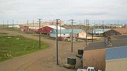 Atqasuk in the summer | |
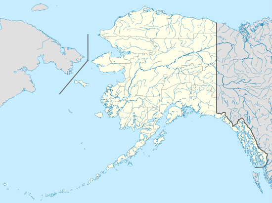 Atqasuk Location in Alaska | |
| Coordinates: 70°28′40″N 157°25′05″W | |
| Country | United States |
| State | Alaska |
| Borough | North Slope |
| Incorporated | October 10, 1982[1] |
| Government | |
| • Mayor | Douglas Whiteman[2] |
| • State senator | Donny Olson (D) |
| • State rep. | John Lincoln (D) |
| Area | |
| • Total | 42.74 sq mi (110.68 km2) |
| • Land | 39.12 sq mi (101.32 km2) |
| • Water | 3.62 sq mi (9.37 km2) |
| Elevation | 56 ft (17 m) |
| Population | |
| • Total | 233 |
| • Estimate (2018)[5] | 250 |
| • Density | 6.39/sq mi (2.47/km2) |
| Time zone | UTC-9 (Alaska (AKST)) |
| • Summer (DST) | UTC-8 (AKDT) |
| ZIP code | 99791 |
| Area code | 907 |
| FIPS code | 02-04500 |
| GNIS feature ID | 1406178, 2419360 |
| Website | www |
Geography
Atqasuk is located at 70°28′40″N 157°25′05″W (70.477663, -157.418056).[9]
According to the United States Census Bureau, the city has a total area of 42.3 square miles (110 km2), of which 38.9 square miles (101 km2) is land and 3.5 square miles (9.1 km2) (8.22%) is water.
Atqasuk has one airport, Atqasuk Edward Burnell Sr. Memorial Airport, that is uncontrolled and has a single 4,370-by-90-foot (1,332 by 27 m) runway at an elevation of 96 feet (29 m).[10]
Demographics
| Historical population | |||
|---|---|---|---|
| Census | Pop. | %± | |
| 1940 | 78 | — | |
| 1950 | 49 | −37.2% | |
| 1960 | 30 | −38.8% | |
| 1980 | 107 | — | |
| 1990 | 216 | 101.9% | |
| 2000 | 228 | 5.6% | |
| 2010 | 233 | 2.2% | |
| Est. 2018 | 250 | [5] | 7.3% |
| U.S. Decennial Census[11] | |||
Atqasuk first appeared on the 1940 U.S. Census as the unincorporated village of "Meade River."[12] It reported on the 1950 census as "Tikikluk."[13] In 1960, it returned again as Meade River.[14] It did not appear on the 1970 census.[15] It next reported on the 1980 U.S. Census as "Atkasook", and was made a census designated place (CDP).[16] It formally incorporated in 1982 as Atqasuk.
As of the 2010 United States Census, there were 233 people living in the city. The racial makeup of the city was 92.3% Native American, 6.9% Black and 0.9% from two or more races.
As of the census[8] of 2000, there were 228 people, 55 households, and 44 families living in the city. The population density was 5.9 people per square mile (2.3/km²). There were 60 housing units at an average density of 1.5 per square mile (0.6/km²). The racial makeup of the city was 4.82% White, 94.30% Native Alaskan, 0.44% Asian, and 0.44% from two or more races.
There were 55 households out of which 50.9% had children under the age of 18 living with them, 47.3% were married couples living together, 21.8% had a female householder with no husband present, and 18.2% were non-families. 16.4% of all households were made up of individuals and none had someone living alone who was 65 years of age or older. The average household size was 4.15 and the average family size was 4.49.
In the city, the age distribution of the population shows 40.4% under the age of 18, 8.8% from 18 to 24, 29.8% from 25 to 44, 15.4% from 45 to 64, and 5.7% who were 65 years of age or older. The median age was 26 years. For every 100 females, there were 113.1 males. For every 100 females age 18 and over, there were 123.0 males.
The median income for a household in the city was $66,607, and the median income for a family was $53,750. Males had a median income of $41,875 versus $27,500 for females. The per capita income for the city was $14,732. About 25.0% of families and 15.6% of the population were below the poverty line, including 4.9% of those under the age of eighteen and 57.1% of those sixty five or over.
Education
The North Slope Borough School District operates the Meade River School in Atqasuk.[17]
References
- 1996 Alaska Municipal Officials Directory. Juneau: Alaska Municipal League/Alaska Department of Community and Regional Affairs. January 1996. p. 30.
- 2015 Alaska Municipal Officials Directory. Juneau: Alaska Municipal League. 2015. p. 35.
- "2018 U.S. Gazetteer Files". United States Census Bureau. Retrieved Jul 1, 2019.
- "Atqasuk city, Alaska". Profile of General Population and Housing Characteristics: 2010 Demographic Profile Data. United States Census Bureau. Archived from the original on February 12, 2020. Retrieved January 23, 2013.
- "Population and Housing Unit Estimates". Retrieved June 4, 2019.
- "Atqasuk". Division of Community and Regional Affairs, Alaska Department of Commerce, Community and Economic Development. Retrieved January 24, 2013.
- "Alaska Taxable 2011: Municipal Taxation - Rates and Policies" (PDF). Division of Community and Regional Affairs, Alaska Department of Commerce, Community and Economic Development. January 2012. Archived from the original (PDF) on 2013-04-25.
- "U.S. Census website". United States Census Bureau. Retrieved 2008-01-31.
- "US Gazetteer files: 2010, 2000, and 1990". United States Census Bureau. 2011-02-12. Retrieved 2011-04-23.
- FAA Airport Master Record for ATK (Form 5010 PDF), effective July 5, 2007.
- "Census of Population and Housing". Census.gov. Retrieved June 4, 2015.
- https://www2.census.gov/prod2/decennial/documents/33973538v1ch11.pdf
- https://www2.census.gov/prod2/decennial/documents/41601749v2p51-54ch2.pdf
- https://www2.census.gov/prod2/decennial/documents/37721577v1p3ch2.pdf
- https://www2.census.gov/prod2/decennial/documents/1970a_ak-01.pdf
- https://www2.census.gov/prod2/decennial/documents/1980a_akABCD-01.pdf
- "Atqasuk." North Slope Borough School District. Retrieved on February 14, 2017.
External links
- Atqasuk at the Community Database Online from the Alaska Division of Community and Regional Affairs
- Maps from the Alaska Department of Labor and Workforce Development: 2000, 2010
- North Slope Borough: Atqasuk
- Arctic Slope Regional Corporation: Atqasuk
- Atqasuk images
Municipalities and communities of North Slope Borough, Alaska, United States | ||
|---|---|---|
Borough seat: Utqiagvik | ||
| Cities | 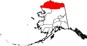 North Slope Borough map | |
| CDPs | ||
| Unincorporated communities | ||
| Ghost towns | ||
| Authority control |
|
|---|