Ashton-Sandy Spring, Maryland
Ashton-Sandy Spring is a census-designated place (CDP) in Montgomery County, Maryland, United States. The CDP is designated to include the two unincorporated communities of Ashton and Sandy Spring.
Ashton-Sandy Spring, Maryland | |
|---|---|
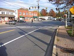 Route 108 in Sandy Spring, Maryland, in November 2006. | |
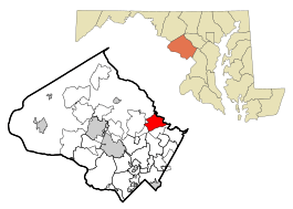 Location of Ashton-Sandy Spring, Maryland | |
| Coordinates: 39°8′54″N 76°59′55″W | |
| Country | |
| State | |
| County | |
| Area | |
| • Total | 7.6 sq mi (19.7 km2) |
| • Land | 7.6 sq mi (19.6 km2) |
| • Water | 0.0 sq mi (0.1 km2) |
| Population (2010) | |
| • Total | 5,628 |
| • Density | 740.5/sq mi (287.1/km2) |
| Time zone | UTC−5 (Eastern (EST)) |
| • Summer (DST) | UTC−4 (EDT) |
| FIPS code | 24-02762 |
Geography
Ashton-Sandy Spring is located at 39°8′54″N 76°59′55″W (39.148270, −76.998599).[1]
According to the United States Census Bureau, the place has a total area of 7.6 square miles (20 km2), of which 7.6 square miles (20 km2) is land and 0.04 square miles (0.10 km2) (0.26%) is water.
Demographics
As of census[2] 2010, there were 5,628 people in 1,839 households, including 1,434 families, in the CDP. The population density was 740.5 people per square mile (287.1/km²). There were 1,936 housing units at an average density of 254.7/sq mi (98.8/km²). The racial makeup of the area was 71.7% White, 14.2% African American, 0.2% Native American, 8.3% Asian, 1.6% from other races, and 3.8% from two or more races. Hispanic or Latino of any race were 6.6% of the population.
Of the 1,839 households 35.9% had children under the age of 18 living with them, 66.6% were married couples living together, 8.5% had a female householder with no husband present, and 22.0% were non-families. 19.1% of households were one person living alone and 12.3% were one person aged 65 or older. The average household size was 2.91 and the average family size was 3.34.
The age distribution was 25.3% under the age of 18, 6.3% from 18 to 24, 16.7% from 25 to 44, 32.9% from 45 to 64, and 18.8% 65 or older. The median age was 46 years. For every 100 females, there were 88.4 males. For every 100 females age 18 and over, there were 85.4 males.
A 2013 survey[2] estimated that the median household income in the area was $119,432, and the median family income was $163,403. Males had an estimated median income of $86,250 versus $94,861 for females. The estimated per capita income for the area was $62,468. The survey estimated about 6.9% of families and 7.2% of the population were below the poverty line, including 9.1% of those under age 18 and 9.7% of those age 65 or over.
References
- "US Gazetteer files: 2010, 2000, and 1990". United States Census Bureau. 2011-02-12. Retrieved 2011-04-23.
- "U.S. Census website". United States Census Bureau. Retrieved 2015-03-03.
Municipalities and communities of Montgomery County, Maryland, United States | ||
|---|---|---|
| Cities | 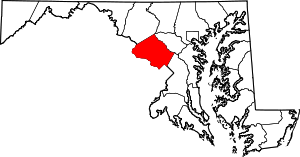 | |
| Towns | ||
| Villages & Special Tax Districts | ||
| CDPs |
| |
| Unincorporated communities | ||
| Footnotes | ‡This populated place also has portions in an adjacent county or counties | |