Porto Torres
Porto Torres (Sassarese: Posthudorra, Sardinian: Portu Turre) is a comune and a city of the Province of Sassari in north-west of Sardinia, Italy. It is situated on the coast at about 25 kilometres (16 mi) east of Capo del Falcone and in the center of the Gulf of Asinara. The port of Porto Torres is the second biggest seaport of the island, followed by the port of Olbia. The town is very close to the main city of Sassari, where the local university takes office.
Porto Torres Posthudòrra | |
|---|---|
| Città di Porto Torres | |
.jpg) City of Porto Torres | |
Location of Porto Torres 
| |
 Porto Torres Location of Porto Torres in Sardinia  Porto Torres Porto Torres (Sardinia) | |
| Coordinates: 40°50′N 8°24′E | |
| Country | Italy |
| Region | Sardinia |
| Province | Sassari (SS) |
| Founded | 46 b.C (as a Roman settlement); 1842 (as an independent comune) |
| Frazioni | Li Lioni, Asinara, Fiume Santo, Platamona |
| Government | |
| • Mayor | Sean Christian Wheeler (Five Star Movement) |
| Area | |
| • Total | 104.41 km2 (40.31 sq mi) |
| Elevation | 17.00 m (55.77 ft) |
| Population (30 October 2019)[2] | |
| • Total | 22,016 |
| • Density | 210/km2 (550/sq mi) |
| Demonym(s) | Turritani or Portotorresi |
| Time zone | UTC+1 (CET) |
| • Summer (DST) | UTC+2 (CEST) |
| Postal code | 07046 |
| Dialing code | 079 |
| ISTAT code | 090058 |
| Patron saint | St. Gavinus , St. Proto, St. Gianuario |
| Saint day | 30 May |
| Website | Official website |
Founded during the 1st century BC as Colonia Iulia Turris Libisonis, it was the first Roman colony of the entire island.
Geography

Porto Torres' territory is situated on the north-west part of Sardinian Coast.
The extension of municipality is almost 10,200 hectare and is subdivided in two parts, with almost the same extension. One part includes the city, the industrial area and the Roman ruins; the latter is formed by the Asinara island with the smaller Isola Piana. This part of territory is, since 1997, a national park.
The morphology of "city part" is flat; the area of Porto Torres and the rest part of north-west Sardinia is characterized by a Nurra flat, there are some hill formations in the middle of the flat. Part of this hill formation is in Porto Torres' territory and the highest elevation of it is Monte Alvaro with a height of 342 m.
The communal territory is crossed by two rivers, Rio Mannu and Fiume Santo. The first draws the edge of Porto Torres territory on west, while instead the latter flows near the city and was used as a fluvial way as early as the Roman age.
History
.jpg)
In ancient times, Turris Libisonis was one of the most considerable cities in Sardinia. It was probably of purely Roman origin, founded apparently by Julius Caesar, as it bore the title Colonia Julia.[3] Pliny described it as a colony, the only on the island in his time, suggesting that there was previously no town on the spot, but merely a fort or castellum.[4] It is noticed also by Ptolemy and in the Itineraries, but without any indication that it was a place of any importance.[5]
The ancient remains still existing prove that it must have been a considerable town under the Roman Empire. According to inscriptions on ancient milestones, the principal road through the island ran directly from Caralis (Cagliari) to Turris, a sufficient proof that the latter was a place much frequented. Indeed, two roads, which diverged at Othoca (modern Santa Giusta) connected Caralis to Turris, the more important keeping inland and the other following the west coast.[3] It was also an episcopal see during the early part of the Middle Ages.
The existing port at Porto Torres, which is almost wholly artificial, is based in great part on Roman foundations; and there exists also the remains of a temple (which, as we learn from an inscription, was dedicated to Fortune, and restored in the reign of Philip), of thermae, of a basilica and an aqueduct, as well as a bridge over the adjoining small river, still called the Fiume Turritano. The ancient city continued to be inhabited till the 11th century, when the greater part of the population migrated to Sassari, about 15 kilometres (9 mi) inland, and situated on a hill.[6] It was partly under Genoese hands before, in the early 15th century, it was conquered by the Aragonese. After the Spanish rule it was part of the Kingdom of Sardinia.
Torres was separated from the comune of Sassari in 1842. At the time the area which had been built around the basilica of San Gavino joined the fishermen's community near the port to form the new Porto Torres.
On 10 May 1942 Benito Mussolini visited the town.[7]
On 18 April 1943 the city was bombed by the Allies.[8]
Main sights
Archaeological sites
- Necropolis of Su Crucifissu Mannu
- Domus de Janas of Campu Perdu (Asinara)
- Nuraghe Biunisi
- Nuraghe Monte Elva
- Nuraghe Margone
- Nuraghe Nieddu
- "Turris Libisonis" Archaeological park
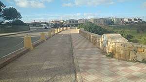
- Roman bridge of Rio Mannu
- Palace of the "Re Barbaro" and domus of Orpheus
- Baths of Maetzke
- Baths of Pallottino
- Domus dei Mosaici
- Tanca Borgona
- The Arcosolium
Architecture
Churches
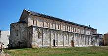
- The 11th-century Basilica of San Gavino, built using only hardstones like marble, porphyry and granite, is the largest Romanesque church in Sardinia. Instead of the usual western facade and eastern apse, the cathedral sports two apses. The crypt holds several Roman sarcophagi.
- Twin churches of "Balai Vicino" and "Balai Lontano"
- Church of "Beata Vergine della Consolata"
.JPG)
.JPG)
Civil architecture
- Palazzo del Marchese
- Antiquarium Turritano
- Seaport museum (Museo del porto)
Military architecture
- Aragonese Tower
- Tower of Abbacurrente
- air-raid shelter "ex caserma dei carabinieri"
- air-raid shelter "scuole De Amicis"
- Batteria antinavale di Ponte Romano
Other
.jpg)
Main plazas
- Piazza Umberto I (A.k.a. Piazza del comune/Piazza mercato) - Main plaza of Porto Torres where there is located the Town Hall.
- Piazza Giuseppe Garibaldi (Simply as Piazza Garibaldi) - Considered as the second main plaza of the town, it is served with many restaurants and taverns.
- Piazza della Consolata - Right in front of Piazza Umberto I, in the other side of Corso Vittorio Emanuele II.
Natural areas
Protected areas
- Asinara national park
- Parco fluviale del Rio Mannu
- Area marina protetta Isola dell'Asinara
- Santuario per i mammiferi marini
Beaches
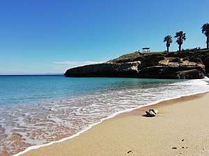
The town of Porto Torres has several free access beaches and cliffs suitable for bathing activities. Main beach is the Balai beach (lit."Spiaggia di Balai"). Other beaches are :
- Fiume Santo
- Renaredda
- Scogliolungo
- Acque Dolci
- Fiordo
- Scoglio Ricco
- Ponte
- Abbacurrente
Main parks
- Parco San Gavino - Considered as the main park it has many playgrounds for children.
- Parco Robert Baden-Powell - Very large park between Tramontana's road and the SP81, with some parking sites.
- Parco per cani Robert Baden-Powell - Parco Robert Baden-Powell dog park.
- Parco Chico Mendes - Small park behind the Hostel Balai.
- Parco Balai vicino - Green area behind the famous Balai beach.
- Pineta La Farrizza - Large artificial pine forest used to do outdoor activities.
Transport
Seaport
.jpg)
.jpg)
.jpg)
In the north-west of Sardinia, the harbor of Porto Torres is the biggest.[9][10] The city has connections with the rest of the Italy, of Spain and France. Not so far from the harbor there is the Maritime Terminal (Stazione marittima). In the same area there is built the new passenger terminal (Terminal passeggeri; the building is still under construction).
Destinations:[11][12][10]
- Propriano (France) - La Méridionale-MCM
- Marseille (France) - La Méridionale-MCM
- Toulon (France) - Corsica Ferries Sardinia Ferries
- Porto Vecchio (Corsica, France) - Corsica Ferries Sardinia Ferries
- Ajaccio (Corsica, France) - La Méridionale-MCM
- Genoa (Italy) - Tirrenia and Grandi Navi Veloci
- Civitavecchia (Italy) - Grimaldi
- Barcellona (Spain) - Grimaldi
From the seaport there is also available a connection for the island of Asinara.
Public transport
Porto Torres belong to the metropolitan network of north Sardinia (lit. "Rete metropolitana del nord Sardegna"[13]). Due to this, the city is well-connected with all nearly towns via intercity autobus thanks to the ARST. Local rides are managed by the local public transport agency (A.t.p. Sassari).
Main roads and highways
Highway SS131/E25 connect the town with the main city Sassari and the chief town Cagliari. Also road SS200 lead the way to Santa Teresa Gallura.
SP81 lead to Platamona, Sorso and Eden beach.
SP42 (A.k.a. "Strada dei due mari") connect the town with Alghero's airport and Alghero.
Train stations
A railway operated by Trenitalia connects the town with Sassari and the rest of the island. The town has two train stations, one built at the end of the 20th century (considered as the main station) and one smaller and more historical built during the 19th century (referred as "Porto Torres marittima").
Education
School
The town has many state high-schools and several state primary schools in its territory.[14][15]
In the urban territory there is also a music school named in memory of the Italian songwriter Fabrizio de Andrè.[16]
Due to the proximity to the city of Sassari and thanks to the intercity lines managed by ARST[17] for the citizens is very easy to reach the near University of Sassari.
Libraries
Public library "Antonio Pigliaru" (lit. Biblioteca Comunale "Antonio Pigliaru") is the only library of the town.
Sports
Football
Main football clubs:
- Porto Torres Calcio (Serie D)
- Turris
- Polisportiva Dilettantistica Quartieri Riuniti (A.k.a. "Quartieri Riuniti")
- Turritana
Tennis
Main association:
- A.S.D. Tennis Club Porto Torres
Basket
Main associations:
- GSD Porto Torres
- CMB Porto Torres
- Silver Basket Porto Torres
- Balai Basket
Martial arts and combat sports
There are many boxing clubs and martial arts schools. Sports like Karate shotokan, MMA, Boxing, Jujitsu, Krav-Maga and Self-defense are very appreciated and practiced by some part of the citizens.
Equestrianism
Right below the ancient Roman bridge of Riu Mannu Porto Torres has a riding hall where the local A.S.D. Centro Ippico Equitazione Porto Torres practice horse riding[18].
Sport facilities
Sports area "Cittadella dello sport"
A 67.000 m² area which offer many sports.
Main area ("Campo sportivo comunale" or "Stadio comunale")
It is a multi-purpose stadium mainly composed with:
- 1 football pitch of 60 x 105 meters (home ground of the A.C. Porto Torres)
- Running track
- Shot put area
- Discus throw area
- Hammer throw area
- Javelin throw area
- Pole vault area
- High jump area
Other areas
- Boxing club "Alberto Mura"
- Tennis club
- 1 football pitch of 105 x 603 meters
- 1 football pitch of 100 x 60 meters
Palasport "Alberto Mura"

A sport facility with a capacity of 1.600 people mainly used as an indoor basketball court.
Skate park
A 1.800 m² skateboard park with a bank ramp of 20°, a square-rail, a pyramid ledges and a quarter pipe.
Football pitch "Angelo Occone"
Football pitch of 100 x 60 meters situated not so far from the town hall.
Other
Artificial pine forest
Called "Pineta la Farrizza", "Pineta Abbacurrente" or "Pineta Balai lontano", it is composed mainly of stone pines.
Bicycle Path
Starting from "Piazza eroi dell'onda" and finishing in the plaza of "Balai lontano", it offers a panoramic view of the sea.
Economy
Industry

Chemical industries support the modern economy of Porto Torres. Fiume Santo, a 1,040 MW power station owned by E.ON, is 5 to 10 kilometres (3 to 6 mi) west from the city, in the municipality of Sassari.[19]
Plans related to industrial conversion are in progress in Porto Torres, where seven research centers are developing the transformation from traditional fossil fuel related industry to an integrated production chain from vegetable oil using oleaginous seeds to bioplastics.[20][21]
Tourism

Starting in 2008, tourism has become a very important activity for the economy of the city. The town have several attractions, both natural and anthropic. The main attraction is the Asinara national park. The Aragonese seaport tower is considered the symbol of the city and because of this it is one of the main tourist attractions. Other main attractions are the Roman bridge of Riu Mannu and the Basilica of Saint Gavinus. Due the decline of the industrial sector, the tourist sector has started to become the leading sector of the local economy (despite the local industrial zone, that importance for the city remains high).
Minor activities
Fishing and farming activities are also practiced around the land.
References
- "Superficie di Comuni Province e Regioni italiane al 9 ottobre 2011". Istat. Retrieved 16 March 2019.
- All demographics and other statistics: Italian statistical institute Istat.
-

- Smith 1857, p. 1241 Cites: Plin. iii. 12. s. 17.
- Smith 1857, p. 1241 Cites: Ptol. iii. 3. § 5; Itin. Ant. p. 83.
- Smith 1857, p. 1241 Cites: De la Marmora, Voy. en Sardaigne, vol. ii. pp. 363,468-72; Smyth's Sardinia, pp. 263-66.
- "Mussolini a Porto Torres - Cinecittà Luce - Unesco". fondoluce.archivioluce.com. Retrieved 2020-04-08.
- "Il bombardamento di 67 anni fa - La Nuova Sardegna". Archivio - La Nuova Sardegna (in Italian). Retrieved 2020-04-08.
- "Porto di Porto Torres", Wikipedia (in Italian), 2020-03-14, retrieved 2020-04-06
- Torres, Comune di Porto. "Arrivare in nave". Comune di Porto Torres (in Italian). Retrieved 2020-04-08.
- "Porto Torres", Wikipedia (in Italian), 2020-04-07, retrieved 2020-04-08
- "Traghetto Porto Torres: confronta tariffe, orari e prenota i biglietti". www.directferries.it (in Italian). Retrieved 2020-04-08.
- "Rete metropolitana del Nord Sardegna", Wikipedia (in Italian), 2020-03-17, retrieved 2020-04-06
- Torres, Comune di Porto. "Scuole dell'obbligo a Porto Torres". Comune di Porto Torres (in Italian). Retrieved 2020-04-06.
- SSIS00400C. "Liceo di Porto Torres". www.iispaglietti.edu.it (in Italian). Retrieved 2020-04-06.
- Torres, Comune di Porto. "Scuola Civica di Musica". Comune di Porto Torres (in Italian). Retrieved 2020-04-06.
- "ARST - - Servizi extraurbani TPL". arst.sardegna.it. Retrieved 2020-04-06.
- "EQUITAZIONE PORTO TORRES - Via Fontana Vecchia 25 - 07046 Porto Torres (SS)40.835658.39495". PagineBianche (in Italian). Retrieved 2020-04-17.
- "Fiume Santo Power Station (Thermoelectric Power Plant), Italy". Retrieved 28 January 2011.
- matrica: green chemicals
- A new age for the Italian chemical industry
Sources
| Wikimedia Commons has media related to Porto Torres. |
| Authority control |
|
|---|