Port Road, Adelaide
Port Road (state route A7) is a major road in Adelaide, South Australia connecting the Adelaide city centre with Port Adelaide.[1] It is 12 km (7.5 mi) long, and has a very wide median strip, giving a total width of approximately 70 m.
Port Road | |
|---|---|
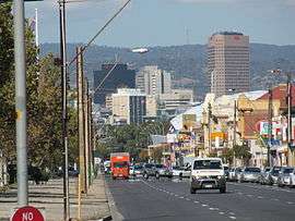 | |
Looking towards the Adelaide city centre from Port Road in Hindmarsh | |
| General information | |
| Type | Road |
| Length | 12 km (7.5 mi) |
| Route number(s) |
|
| Former route number | |
| Major junctions | |
| SE end | West Terrace, Adelaide |
| |
| NW end | |
| Location(s) | |
| Major suburbs | Adelaide Park Lands, Thebarton, Hindmarsh, West Croydon, Kilkenny, Woodville South, Woodville, Woodville West, Albert Park, Cheltenham, Alberton, Port Adelaide |
The original design, conceived soon after the establishment of Adelaide, was to accommodate a standard road and a canal, with the canal later replaced in the plans by a railway line.[2] The canal and railway line were never created in the road allotment: the railway line when built in 1853 was built approximately 1 km to the east. Since the extension of the Glenelg tram in 2009–10, 200 metres of median strip at the city end is occupied by tram lines.
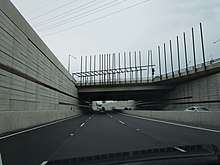
In the 1968 Metropolitan Adelaide Transport Study (MATS plan) the road was destined to be upgraded to become the Port Freeway. The plan fell through, yet in 2005 the Government of South Australia announced a 600 m tunnel for South Road below Port Road and the railway line. The Torrens Road to River Torrens project to upgrade South Road to include a free-flowing road in a trench under Port Road and several other intersections started construction in 2015 and was completed by the end of 2018.[3][4]
Some routes in Adelaide were renumbered in 2017. Port Road had been designated route A21 (city ring route) between West Terrace and Park Terrace. After the change, the West Terrace end is not numbered, and it bears route R1 (city ring route) between James Congdon Drive and Park Terrace.
Major intersections
| LGA[5] | Location[5] | km | mi | Destinations[6] | Notes |
|---|---|---|---|---|---|
| Adelaide | Adelaide city centre | 0 | 0.0 | West Terrace / North Terrace | |
| City of Adelaide, City of West Torrens | Thebarton | 1 | 0.62 | no route number southeast of this junction; R1 north of it | |
| City of Adelaide, City of West Torrens, City of Charles Sturt | Hindmarsh | 2.1 | 1.3 | ||
| Charles Sturt | Hindmarsh, West Hindmarsh, Croydon | 3.3 | 2.1 | Major city bypass. South Road is being upgraded so through traffic passes under Port Road; expected completion end of 2018.[7] | |
| Allenby Gardens, Beverley, West Croydon | 5.1 | 3.2 | |||
| Beverley, Kilkenny, Woodville Park | 5.4 | 3.4 | Kilkenny Road – Regency Road | ||
| Albert Park, Cheltenham, Woodville | 7.8 | 4.8 | Cheltenham Parade / West Lakes Boulevard – AAMI Stadium, West Lakes | ||
| City of Charles Sturt / City of Port Adelaide Enfield | Albert Park, Queenstown, Cheltenham | 9.0 | 5.6 | Old Port Road | |
| Port Adelaide Enfield | Queenstown, Alberton | 9.7 | 6.0 | ||
| Queenstown | 11.0 | 6.8 | Continues as Commercial Road, Port Adelaide | ||
| 1.000 mi = 1.609 km; 1.000 km = 0.621 mi | |||||
 Location of Port Road in Adelaide.
See also
![]()
References
- 2003 Adelaide Street Directory, 41st Edition. UBD (A Division of Universal Press Pty Ltd). 2003. ISBN 0-7319-1441-4.
- Was there ever going to be a canal on Port Road and is that why it is so wide?, ABC, 2 November 2018
- "North-South Corridor: Torrens Road to River Torrens". Department of Planning, Transport and Infrastructure, Government of South Australia. 5 August 2015. 145594. Retrieved 8 August 2015.
- "T2T". T2T Alliance. 31 July 2015. Retrieved 8 August 2015.
- "Property Location Browser". Government of South Australia. Archived from the original on 12 October 2016. Retrieved 5 March 2016.
- Google (5 March 2016). "Port Road, Adelaide to Port Adelaide" (Map). Google Maps. Google. Retrieved 5 March 2016.
- "Project Scope". T2T Alliance. Retrieved 10 January 2017.
External links