Tapleys Hill Road
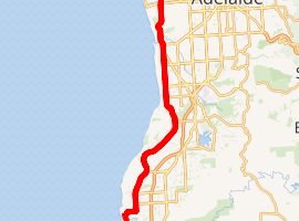
Tapleys Hill Road is a north-south arterial road in the western suburbs of Adelaide, Australia.[1] It runs parallel to the coast between Port Road and Anzac Highway. It is designated as Route A15 which continues south of Anzac Highway as Brighton Road.
Tapleys Hill Road | |
|---|---|
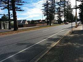 | |
Tapleys Hill Road at Glenelg North, facing north | |
| |
| Coordinates | |
| General information | |
| Type | Road |
| Length | 13 km (8.1 mi) |
| Route number(s) | |
| Major junctions | |
| North end | |
| South end | |
| Location(s) | |
| Major suburbs | Seaton, Fulham Gardens, Fulham, Lockleys, West Beach, Glenelg North |
Tapleys Hill Road passes through the City of Port Adelaide Enfield, City of Charles Sturt, City of West Torrens and City of Holdfast Bay.
Places of interest located on Tapleys Hill Road include Royal Adelaide Golf Course, Adelaide Shores Golf Park, Harbour Town and a viewing area at the western end of Adelaide Airport.
Prior to an upgrade in the 1990s, Tapleys Hill Road's southern end was joined to Anzac Highway about 100 metres to the west of where it currently lays.[2] The upgrade involved re-aligning the roadway, and taking Tapleys Hill Road to Brighton Road's northern end, removing congestion in a busy area. The old roadway still exists, now named as Old Tapleys Hill Road, and is rarely used as a through route, servicing mainly residents of the area.
Tapleys Hill Road is the northern part of Route A15 which continues past the southern end of Tapleys Hill Road onto Brighton Road, then Ocean Boulevard, Lonsdale Road and Dyson Road. Route A15 continues through Port Noarlunga on parts of Murray Road, Gawler Street, Gray Street, Saltfleet Street, Commercial Road and by Maslin Beach, Old Coach Road.
Tapleys Hill (35°03′S 138°34′E) is located west of Flagstaff Road and east of Main South Road on the boundary of the suburbs of O'Halloran Hill and Flagstaff Hill, near the Victoria Hotel (colloquially "Top of Taps Hotel"). The hill was named for Thomas Tapley (1789–1856), who arrived in South Australia aboard the Rajahstan in November 1838 and took up land in that location.[3] The hill is the source of the name for Tapleys Hill Road. The road forms the initial half of the traditional route from Port Adelaide to Tapley's Hill, the remainder of the traditional route, from Glenelg onwards, being via Diagonal Road and since-altered local roads up the hill from Darlington.
See also
![]()
References
- 2003 Adelaide Street Directory, 41st Edition. UBD (A Division of Universal Press Pty Ltd). 2003. ISBN 0-7319-1441-4.
- Adelaide Street Directory, 28th Edition. Adelaide: UBD. 1990. ISBN 0-7319-0115-0.
- "Manning index to South Australia". State library of South Australia. Retrieved 1 February 2016.