Goodwood Road, Adelaide
Goodwood Road is a major north–south arterial road, approximately 10 kilometres long, in Adelaide, South Australia. It runs between the Adelaide city centre and the southern suburbs of Adelaide – Pasadena and Panorama, and has a speed limit of 60 km/h (37 mph).[1]
Goodwood Road | |
|---|---|
 | |
Southern section of the Goodwood Subway in 2008 | |
| General information | |
| Type | Road |
| Length | 10 km (6.2 mi) |
| Major junctions | |
| North end | West Terrace, Adelaide |
| South end | Fiveash Drive, Pasadena |
- For other similarly named roads, see Goodwood Road (disambiguation)
Concourse
Starting at the intersection of Anzac Highway, West Terrace and South Terrace in the south-western corner of the Adelaide city centre, the road continues south, through the southern Adelaide Parklands.
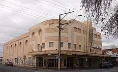
Goodwood Road continues south through the suburb of Wayville, passing the Royal Adelaide Showgrounds. The traffic lights at Leader Street mark the boundary with the suburb of Goodwood, and the location of the Goodwood Park Hotel. The road then crosses the Glenelg tramline and, although it retains 4 lanes, the speed limit is reduced to 50 km/h, and the road narrows as it passes the Goodwood library, civic centre and shopping precinct which also contains a theatre, the Capri cinema, numerous restaurants, and the Goodwood Primary school. Victoria Street marks the boundary with the suburb of Millswood. The road continues past the former Goodwood Orphanage through the so-called "Goodwood Subway", (adjacent to Millswood railway station). This is a deep road underpass which has double-lane traffic in both directions, and an elevated pedestrian walkway along the western wall. It was originally built for the Goodwood Road tram traffic to pass safely under the Belair railway line and the main Adelaide-Melbourne Railway Line. Although the trams stopped travelling along Goodwood Road, and the tracks were removed, many decades ago, the subway continues to provide grade-separation between a very busy arterial road and a railway line with long, slow freight trains.
Past the subway, the road widens and the speed limit returns to 60 km/h again, and continues south through the suburbs of Kings Park, ( east side - possibly Adelaide's smallest suburb), and Clarence Park (west side) to the intersection with Cross Road and the A3, a busy intersection now monitored by speed and red light cameras.
Passing through the suburbs of Cumberland Park (west side) and Westbourne Park (east side), the next major intersection is where Edward Street and Grange Road meet, and marks the start of Colonel Light Gardens (east side) and Daw Park (west side). Here the road widens considerably to 6 lanes and dual carriageway separated by a wide central grassed nature strip containing many trees. At the rather disjointed intersection of Springbank and Daws roads, although it retains 6 lanes and dual carriageway, the road narrows and its wide central nature strip is replaced by a narrow concrete curb. Also located at this intersection are the Repatriation General Hospital, Daw Park, the Pasadena High School, the Douglas Mawson Institute of TAFE and Bedford Industries.
Goodwood Road continues south through Pasadena (west side) and Panorama (east side) for almost another kilometre, passing Centennial Park Cemetery on the west side before bending in a south-westerly direction. It is at this point that the name "Goodwood Road" ends, and is replaced by Fiveash Drive, although there is no change in the structure of the thoroughfare itself.
 Capri Cinema
 Goodwood Orphanage
 Goodwood Subway and Belair Railway Line
 Church of Christ, Colonel Light Gardens
 Ayliffes Road bridge: The above ground road bridges were assembled on-site and moved into their final position using multi-wheeled lifters.
See also
- Transport in Adelaide
- Roads in Australia
References
- 2003 Adelaide Street Directory, 41st Edition. UBD (A Division of Universal Press Pty Ltd). 2003. ISBN 0-7319-1441-4.