Thebarton, South Australia
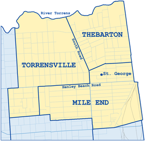
Thebarton (/ˈθɛbərtən/ THEB-ər-tən), formerly Theberton, is an inner-western suburb of Adelaide, South Australia in the City of West Torrens. The suburb is bounded by the River Torrens to the north, Port Road and Bonython Park to the east, Kintore Street to the south, and South Road to the west.
| Thebarton Adelaide, South Australia | |||||||||||||||
|---|---|---|---|---|---|---|---|---|---|---|---|---|---|---|---|
| Population | 1,431 (2016 census)[1] | ||||||||||||||
| Established | 1839[2] | ||||||||||||||
| Postcode(s) | 5031 [3] | ||||||||||||||
| Location | 2 km (1 mi) W of Adelaide | ||||||||||||||
| LGA(s) | City of West Torrens | ||||||||||||||
| State electorate(s) | West Torrens | ||||||||||||||
| Federal Division(s) | Adelaide | ||||||||||||||
| |||||||||||||||
Many buildings and landmarks that bear the name of Thebarton were in the history municipality, the Town of Thebarton, which included most of the adjoining suburb of Torrensville. These include the Thebarton Oval, the Thebarton croquet and bowls club, Thebarton Theatre, and Thebarton Senior College. The historic Adelaide Gaol, nominally shown as being in Thebarton, and the adjacent Thebarton Barracks of the South Australia Police actually lie within the northwestern Adelaide Park Lands.
The Thebarton campus of the University of Adelaide, also known as Adelaide University Research Park, occupies a complex of former industrial buildings in the northeastern corner of the suburb.
History
Prior to European settlement, the areas now known as Thebarton and Hindmarsh were called Karraundongga (meaning "red gum spear place") by the Kaurna people, who would craft spears from the red gum branches gathered on the banks of the Torrens there.[4]
The suburb of Thebarton was named after the home of Colonel William Light, the first Surveyor-General of the colony of South Australia, where he lived with his de facto wife Maria Gandy and her brothers.[5] Light named his home after Theberton Hall of Suffolk, England, where he was educated. The area was known as Theberton until approximately 1840,[6] with the variant spelling now accredited to a typographical error, rather than a corruption of "The Barton", based on the Old English bere-tun, meaning "barley farm", as was thought for some time.[7]
Colonel Light surveyed the town-acre as Section 1 and built Theberton Cottage towards the northern part of the area. The area was first subdivided for housing in February 1839, although it took a number of years for the housing to establish, Thebarton Post Office opening on 24 October 1850.[8] By 1866 the population was estimated at around 450 people.
Thebarton Racecourse, which operated from as early as 1838 to 1869, was formed on grazing land in the area now known as Mile End, and later subdivided and completely built over.[9]
Demographics
Thebarton has a significant Greek-Australian population and is the suburb with the largest Greek Australian population per capita in Australia. In fact, according to census data released by the Australian Bureau of Statistics in 2001, the suburbs of Thebarton and neighbouring Torrensville together are home to 4,471 Greek-Australians; i.e., 18.7 per cent of the total population.
Local government
Thebarton was part of the then largely rural District of West Torrens until 1883, when the residents of the more urban suburbs of Thebarton, Mile End and Torrensville successfully petitioned to become the Corporation of the Town of Thebarton.[10]
In 1997 the Town of Thebarton re-amalgamated with the City of West Torrens.[11]
Landmarks
.jpg)
.jpg)

- St George Greek Orthodox Church on Rose Street, Adelaide's largest Greek Orthodox church
- The Ice Arena, home of the Adelaide Adrenalines, who play in the Australian Ice Hockey League
- Thebarton Oval, former home of the West Torrens Football Club in the South Australian National Football League; now home to the South Australian Amateur Football League.
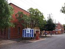
- The Thebarton Incinerator on West Thebarton Road was designed by Walter Burley Griffin in 1935,[12] completed in 1937, and decommissioned in 1964.[13] It is one of two Burley Griffin buildings listed among the 120 nationally significant 20th-century buildings in South Australia,[14] the other being the Hindmarsh Incinerator at Brompton.
- The well-known Thebarton Theatre is in the neighbouring suburb of Torrensville
- The Adelaide Gaol is easterly-adjacent to Thebarton in the western Adelaide parklands.
- A rectangular memorial on the corner of Albert and Maria Streets, dedicated to Maria Gandy, William Light's partner, was unveiled on the 200th anniversary of her birth on 23 November 2011. On each of four sides is an inscription celebrating her roles as pioneer, settler, carer and mother.[15]
Heritage listings
Thebarton has a number of heritage-listed sites, including:
- 39A Dew Street: Lady Gowrie Child Centre [16]
- 1 George Street: Squatters Arms Hotel [17]
- 42 and 42A Phillips Street: Thebarton Baptist Church and Hall [17]
- 77 Port Road: Southwark Hotel [18] (pronounced /ˈsʌðərk/)
- 35-37 Stirling Street: Faulding's Eucalyptus Oil Distillery [19]
- 34-36 West Thebarton Road: Thebarton Incinerator [20]
References
- Australian Bureau of Statistics (27 June 2017). "Thebarton (State Suburb)". 2016 Census QuickStats. Retrieved 6 August 2019.

- Place names of South Australia The Manning Index of South Australian History. State Library of South Australia. Retrieved 28 April 2014.
- Australia Post - Postcode:Thebarton, SA (28 April 2014)
- Payne, P. (1996). Thebarton, Old and New. Thebarton City Council. ISBN 0 646 30157 8.
- Harris, Samela (23 November 2011). "First lady Maria recognised at last". AdelaideNow. The Advertiser. Retrieved 23 October 2019.
- "Search result for 'Thebarton, SUB'". Property Location Browser. Government of South Australia. 11 March 2009. SA0066045. Retrieved 6 September 2017.
Originally a private subdivision of section 46. Name of the house was taken from Colonel Light's English home - Theberton Hall. Thebarton was the first village laid out outside of the City of Adelaide. Available evidence suggests that the current spelling with a central "a" has arisen through a typographic error. Proposal in 1982 to alter the name to Theberton not approved by Geographical Names Board. Portion added in 1945.
- "Place names of South Autralia: T". State Library of South Autralia. The acceptance of Thebarton with an 'a' instead of an 'e' is credited to a typographical error and not the some time held view that it was a corruption of 'The Barton' based on the Old English bere-tun meaning 'barley farm'. Retrieved 23 October 2019.CS1 maint: others (link)
- Premier Postal History. "Post Office List". Premier Postal Auctions. Retrieved 26 May 2011.
- Payne 1996, pp. 49-54, 71-72.
- Payne 1996.
- City of WestTorrens > Local history > Story of West Torrens Accessed 28 April 2014.
- Building Details - Architects of South Australia > Thebarton Incinerator Accessed 13 May 2014.
- Payne 1996, pp. 138–140.
- 120 notable buildings - Australian Institute of Architects Accessed 8 May 2014.
- "Maria Gandy". Monument Australai. Retrieved 23 October 2019.
- "Lady Gowrie Child Centre". South Australian Heritage Register. Department of Environment, Water and Natural Resources. Retrieved 11 September 2016.
- "Squatters Arms Hotel". South Australian Heritage Register. Department of Environment, Water and Natural Resources. Retrieved 11 September 2016.
- "Former Thebarton Baptist Church & Hall". South Australian Heritage Register. Department of Environment, Water and Natural Resources. Retrieved 11 September 2016.
- "Southwark Hotel". South Australian Heritage Register. Department of Environment, Water and Natural Resources. Retrieved 11 September 2016.
- "Former Thebarton Incinerator designed by Walter Burley Griffin". South Australian Heritage Register. Department of Environment, Water and Natural Resources. Retrieved 11 September 2016.