Poland A and B
Poland A and B (Polish: Polska "A" i "B") refers to the historical, political and cultural distinction between the western and the eastern part of the country, with Poland "A", west of the Vistula, being much more developed (GDP per capita 3:1) and having faster growth than Poland "B", east of the river. The General Secretary of Krajowa Izba Gospodarcza Marek Kłoczko, said in his 2007 interview that the divisions are more spread out and forming three separate categories, Poland "A" is the metropolitan cities, Poland "B" is the rest of the country, and Poland "C" is the plains and the landscape parks east of the Vistula (Poland "Z", according to Kłoczko), which require a different treatment.[1]
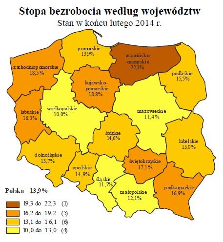
Reportedly, Poland's well-off cities are Warsaw, Kraków, Wrocław, and Poznań, and the ones struggling with less investment are in the east: Rzeszów, Lublin, Olsztyn and Białystok.[1] However, current unemployment statistics for Poland in general fail to show that distinction and even indicate an opposite trend in recent years, with the northwest reporting rates of unemployment higher than east-central Poland. In 2014, among the highest in the nation were the Kujawsko-Pomorskie and Zachodniopomorskie (compare the historic railroad map and the administrative map, right, with the 2014 unemployment map, from business portal eGospodarka.pl);[2] while among the lowest in the country was the east-central Mazowieckie.[3]

Distinction
The distinction is unofficial and in some ways oversimplified, but it is widely acknowledged and discussed in Poland.
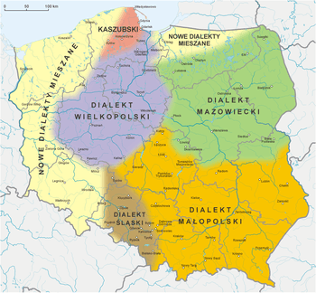
Historically, the source of Poland "A" and "B" can be traced to the period of the partitions of Poland, and different policies of the partitioners, which resulted in a much larger industrial development of the Prussian partition, compared to the Austrian and Russian partitions (including the so-called eastern Kresy) where the imperial exploitation policies were rampant.[1]
In this divide it has to be noted that Poland's borders were changing over the centuries. They moved westward after 1945, to reflect the Poland of the Piasts and the Poland of Jagiellonians. For instance, Warsaw was initially a settlement in eastern Poland. When it became a capital city in the 16th century, and historically in the developed as a central part of the Kingdom of Poland (the Crown), later western-central part of the Commonwealth. Now is situated in the central-eastern part of it. The slower growing western provinces are often former German regions which were already densely populated and well-developed in terms of infrastructure and industry before 1945, now populated mostly by Poles from the former Eastern Polish regions. For example, the above-mentioned Olsztyn was part of Prussia since the times of the Teutonic Order.
Politics

The difference between Poland's "A" and "B" is particularly evident in the voting patterns of the two regions. During the 1990s, Poland "A" tended to favour the Democratic Left Alliance (Sojusz Lewicy Demokratycznej, or SLD), as a secular, socially liberal de facto successor in post-1989 politics to the former communist party. Poland "B" on the other hand voted either PSL (economically liberal but socially conservative) or the Solidarity (″right-wing″) camp (socially conservative). Since c. 2005, Poland saw a realignment in its political system. Residents of Poland "A" (incl. the city of Warsaw in Poland "B") have supported the liberal party Civic Platform (PO). Residents of Poland "B", on the other hand, tend to support the national conservative Law and Justice party (PiS).
See also
- List of Polish voivodeships by GDP per capita
- Recovered Territories
References
- Iwona Borkowska, Polska Polsce nierówna, Raport Polska.pl 2008-06-04. Internet Archive. Retrieved December 16, 2014.
- "Stopa bezrobocia 2014". Map of unemployment by region 2014. eGospodarka.pl. Archived from the original on April 8, 2015. Retrieved 8 April 2015.
- "Unemployment in Poland in February 2014". Raporty i prognozy. eGospodarka.pl.
At the end of February 2014 the highest unemployment rate in Poland was found in Voivodeships: Warmińsko-mazurskie (22.3%), Kujawsko-Pomorskie (18.8%), Zachodniopomorskie (18.5%), Świętokrzyskie (17.1%), Podkarpackie (16.9%) and Lubuskie (16.3%). The lowest unemployment rates in the country were found in: Wielkopolskie (10.0%), Mazowieckie (11.4%), Śląskie (11.7%) and Małopolskie (12.1%).
- Wiesław Samecki, Ekonomia 3: Centralny Okręg Przemysłowy 1936-1939, Wydawnictwo Uniwersytetu Wrocławskiego, 1998, ISBN 83-229-1634-5. Introduction.
- Kozak M., Pyszkowski A., Szewczyk R. (red.) 2001, Słownik Rozwoju Regionalnego, PARR, Warszawa.
- Iwona Borkowska, Polska Polsce nierówna, Raport Polska.pl 2008-06-04. Internet Archive.
- Gazeta Wyborcza (1999) 'Polska A, B i C' (Poland A, B and C), August 4
Poland articles | |||||||
|---|---|---|---|---|---|---|---|
| History |
|  | |||||
| Geography | |||||||
| Politics | |||||||
| Economy |
| ||||||
| Culture |
| ||||||
| |||||||