Pinamar
Pinamar is an Argentine coastal resort city located on the coast of the Atlantic Ocean in Buenos Aires Province. It has about 25,397 inhabitants as per the 2010 census [INDEC].
Pinamar | |
|---|---|
City | |
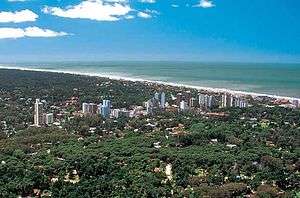 Aerial view of the city | |
 Pinamar Location in Argentina | |
| Coordinates: 37°06′S 56°51′W | |
| Country | |
| Province | |
| Partido | Pinamar |
| Founded | February 14, 1943 |
| Elevation | 17 m (56 ft) |
| Population (2010 census) | |
| • Total | 25,397 |
| CPA Base | B 7167 |
| Area code(s) | +54 2254 |
| Website | Official website |
Located less than 400 km (249 mi) south of Buenos Aires, it is one of several small seaside communities that line the coast. Since Pinamar's main attraction is the ocean, it is a fairly quiet town during the winter months. Tourism fuels the economy during the summer. Several other coastal towns are right beside Pinamar. If you move south, you will have the towns of Ostende, Valeria del Mar, and finally Cariló.
Two facts set Pinamar apart from most of the other Argentine beach cities: it is a planned city with a very strict building code, and it has been artificially turned from wild sand dunes into a forest (mostly of pine trees, which explains the "pina" in the town's name).
City planning, as defined by founding architect Jorge Bunge and maintained by elected authorities ever since, translates into a city mostly made up of residential houses with open gardens; that, together with the pine forest, combine to make the city a very nice setting. That explains why it has been chosen as the summer resort for many well-to-do Argentinians, in particular those living in Buenos Aires.
Pine planting was originally started in Cariló -- a town nearby Villa Gesell and copied in Pinamar, although the city plan for Villa Gesell was not as carefully laid out or kept through the years.
Climate
| Climate data for Pinamar | |||||||||||||
|---|---|---|---|---|---|---|---|---|---|---|---|---|---|
| Month | Jan | Feb | Mar | Apr | May | Jun | Jul | Aug | Sep | Oct | Nov | Dec | Year |
| Average high °C (°F) | 25.8 (78.4) |
25.0 (77.0) |
23.6 (74.5) |
20.4 (68.7) |
17.0 (62.6) |
13.6 (56.5) |
13.3 (55.9) |
14.3 (57.7) |
16.1 (61.0) |
18.8 (65.8) |
21.7 (71.1) |
25.0 (77.0) |
19.6 (67.3) |
| Daily mean °C (°F) | 20.4 (68.7) |
20.1 (68.2) |
18.9 (66.0) |
15.3 (59.5) |
12.4 (54.3) |
9.1 (48.4) |
8.6 (47.5) |
9.3 (48.7) |
11.4 (52.5) |
13.8 (56.8) |
16.1 (61.0) |
19.4 (66.9) |
14.6 (58.3) |
| Average low °C (°F) | 15.8 (60.4) |
15.5 (59.9) |
14.6 (58.3) |
10.6 (51.1) |
8.5 (47.3) |
5.3 (41.5) |
4.8 (40.6) |
4.9 (40.8) |
6.9 (44.4) |
9.3 (48.7) |
11.1 (52.0) |
14.4 (57.9) |
10.1 (50.2) |
| Average precipitation mm (inches) | 136 (5.4) |
54 (2.1) |
86 (3.4) |
69 (2.7) |
90 (3.5) |
46 (1.8) |
57 (2.2) |
50 (2.0) |
54 (2.1) |
62 (2.4) |
72 (2.8) |
119 (4.7) |
895 (35.2) |
| Average precipitation days | 10 | 8 | 9 | 9 | 10 | 9 | 9 | 9 | 8 | 10 | 10 | 10 | 111 |
| Average relative humidity (%) | 70 | 72 | 74 | 76 | 79 | 79 | 81 | 76 | 77 | 73 | 69 | 70 | 75 |
| Source: Servicio Meteorológico Nacional[1] | |||||||||||||
Sister cities

References
- "Datos Estadísticos (Período 1971–1980)" (in Spanish). Servicio Meteorológico Nacional. Retrieved October 26, 2015.
- "Interactive City Directory". Sister Cities International. Archived from the original on 20 August 2014. Retrieved 11 March 2014.
External links
| Wikimedia Commons has media related to Pinamar, Buenos Aires. |
- (in Spanish) Official Website
- (in Spanish) Municipal information: Municipal Affairs Federal Institute (IFAM), Municipal Affairs Secretariat, Ministry of Interior, Argentina. (in Spanish)
- (in Spanish) Revista 365: Pinamar Lifestyle Magazine
- (in Spanish) Tourist Guide to Pinamar Argentina
- (in Spanish) Information on Cariló in Pinamar
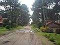 Nautilus Street
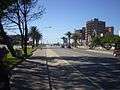 Bunge Boulevard
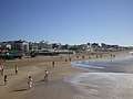 View of the beach from the pier