Salta Province
Salta (Spanish pronunciation: [ˈsalta]) is a province of Argentina, located in the northwest of the country. Neighboring provinces are from the east clockwise Formosa, Chaco, Santiago del Estero, Tucumán and Catamarca. It also surrounds Jujuy. To the north it borders Bolivia and Paraguay and to the west lies Chile.
Salta Provincia de Salta | |
|---|---|
| Province of Salta | |
 Flag  Coat of arms | |
| Nickname(s): La Linda (The beautiful) | |
.svg.png) Location of Salta Province within Argentina | |
| Country | Argentina |
| Capital | Salta |
| Departments | 23 |
| Municipalities | 58 |
| Government | |
| • Governor | Gustavo Sáenz (Front Saenz Governor/Frente Sáenz Gobernador) |
| • Deputies | 7 |
| • Senators | 3 |
| Area | |
| • Total | 155,488 km2 (60,034 sq mi) |
| Population (2010[1]) | |
| • Total | 1,214,441 |
| • Rank | 8th |
| • Density | 7.8/km2 (20/sq mi) |
| Demonym(s) | salteño/a |
| Time zone | UTC−3 (ART) |
| ISO 3166 code | AR-A |
| HDI (2016) | 0.830 Very High (19th)[2] |
| Website | www |
History
Before the Spanish conquest, numerous native peoples (now called Diaguitas and Calchaquíes) lived in the valleys of what is now Salta Province; they formed many different tribes, the Quilmes and Humahuacas among them, which all shared the Cacán language. The Atacamas lived in the Puna, and the Wichís (Matacos), in the Chaco region.
The first conquistador to venture into the area was Diego de Almagro in 1535; he was followed by Diego de Rojas. Hernando de Lerma founded San Felipe de Lerma in 1582, following orders of the viceroy Francisco de Toledo, Count of Oropesa; the name of the city was soon changed to "San Felipe de Salta". By 1650, the city had around five hundred inhabitants.
.jpg)
An intendency of "Salta del Tucumán" was created within the Viceroyalty of the Río de la Plata. In 1774, San Ramón de La Nueva Orán was founded between Salta and Tarija (Tarija was added to the intendency later, in 1807). In 1783, in recognition of the growing importance of the city, the capital of the intendency of Salta del Tucumán was moved from San Miguel de Tucumán to Salta.
The battle of Salta in 1813 freed the territory from Spain, but occasional attacks were mounted from the Viceroyalty of Peru as late as 1826. Gervasio de Posadas created the Province of Salta in 1814, containing the current provinces of Salta, Jujuy, and parts of southern Bolivia and northern Chile.
Exploiting internal Argentine conflicts that arose after the Argentine Declaration of Independence, Bolivia annexed Tarija in 1826. In 1834, Jujuy withdrew from Salta and became a separate province. The borders of Salta were further reduced in 1900, with the loss of Yacuiba to Bolivia.
The National Government of Los Andes, constituted from the province in 1902 with a capital at San Antonio de los Cobres, was returned to Salta Province in 1943 as the Department of Los Andes.
Antonio Alice's painting, La muerte de Güemes, which received a Gold Medal at the Centenary Exposition, is on display at the offices of the Salta Provincial Government.[3]
Geography

The total land area of the province is 155,488 km2 (60,034 sq mi), making it the sixth largest province by area in Argentina.[4]:14–15 The main rivers of the province are the Pilcomayo, Bermejo, and the Juramento, which later becomes the Salado River.[4]:15 Salta Province is located at a geologically active region, and suffers from occasional earthquakes. There have been four earthquakes of note in the province:
- In 1692, registering 7.0 on the Richter magnitude scale, and at IX (Violent) on the Mercalli intensity scale,
- In 1844, registering 6.5 on the Richter magnitude scale, and VII (Very strong) Mercalli intensity,
- In 1948, registering 7.0 on the Moment magnitude scale (MMS), and IX (Violent) Mercalli intensity, and
- In 2010, registering 6.1 or 6.3 (MMS), and VI (Strong) Mercalli intensity.
The 1692 earthquake was the inspiration for Salta's annual citywide festival, held on 16 September, in honor of El Señor y la Virgen del Milagro.[5]
Climate
The province is located in the tropical zone and has a warm climate in general, though it has marked variation in climate types owing to the variation in altitudes.[6] The orientation of the Andes influences the distribution of precipitation within the province.[6]
The easternmost parts of the province have a semi-arid climate with a dry winter season.[6][7] The mean annual temperature and precipitation are 20 °C (68.0 °F) and 500 millimetres (19.7 in).[6][7] Temperatures can reach up to 47 °C (116.6 °F) during summers, while they can fall down to −5 °C (23.0 °F) during winters.[6][7]
The first slopes of the Andes force the moist, easterly winds to rise, provoking very high condensation leading to the formation of clouds that generate copious amounts of rain.[8] The eastern slopes of the mountains receive between 1,000 to 1,500 mm (39 to 59 in) of precipitation a year, although some places receive up to 2,500 mm (98 in) of precipitation annually owing to orographic precipitation.[8][9] Most of the precipitation is concentrated in the summer, with winters being dry.[10] The high rainfall on these first slopes creates a thick jungle that extends in a narrow strip along these ranges, creating an area of great species diversity.[6][10] At higher altitudes on these slopes, the climate is cooler and more humid, with the vegetation consisting of deciduous and pine trees.[10]
Between the high altitudes to the west and the low plains to the east lie the valleys.[7] The climate of these valleys is temperate, allowing for human settlement and agricultural activities.[7] Mean annual precipitation is around 1,000 mm (39 in), most of it during summer.[7] Mean temperatures exceed 20 °C (68.0 °F) during the summer, while during winter, they are below 14 °C (57.2 °F).[7]
Further west, the Altiplano is a plateau at 3,000 m to 4,000 m above sea level. The climate is arid and cold: high temperatures vary little (since the warmer season is cloudy, and the coolest is sunny), ranging from 14 °C to 21 °C (57F to 70F); night temperatures go from 6 °C (43F) in midsummer, to -8 °C (18F) in midwinter, and extremes under -15 °C (5F) might be recorded. All rain falls exclusively in the summer, with values between 200 mm and 400 mm in total. Several salt flats exist in this area.
At the highest altitudes found in the western parts of the province, the climate is arid and cold, with large diurnal ranges (temperature range between day and night).[6]
Economy
Salta's economy is relatively underdeveloped, yet diverse. Its economy in 2006 was estimated at US$5.141 billion or, US$4,764 per capita, 45% below the national average.[11] In 2012, its economy was estimated at $30.613 billon pesos (about US$6.743 billion) or $23,971 pesos (about US$5,280) per capita.[12][13]
Manufacturing plays a significant role in Salta, adding 20% to the economy. Gas and petroleum from the Tartagal, Aguas Blancas, Madrejones and Campo Durán centres is transported to Buenos Aires and Rosario by pipes. There is also an oil refinery located at Campo Durán. Mining includes uranium at Iruya, La Poma and San Carlos.
Agriculture and its derived industries are still an important activity in the province, adding over 10% to output. Tobacco, sugar cane and viticulture are the most important and produce most of the exports from the area. Other crops mostly for local consumption are maize, beans, citrus, bananas, and tomatoes. The sugar cane is processed in plants in Salta before it is sent to the rest of Argentina and other countries. The plant in San Martín de Tabacal is the most important of them. The famous wines of the Valles Calchaquíes region (mainly Torrontés, Malbec and Cabernet Sauvignon) near Cafayate are produced in numerous vineyards of diverse sizes. American breeds of cattle are raised only on the humid subtropical east, along with some sheep and goats.
Tourism
The Salta province is home to a number of natural, social and historic attractions.
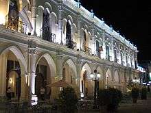
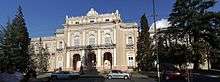
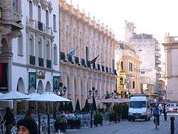
The provincial capital city, also named Salta and nicknamed "La Linda" ("The beautiful") is both an important tourist destination, and the centre point for visiting the rest of the province. The city holds different attractions; among them are its colonial houses and cathedral, and the Museo de Arqueología de Alta Montaña de Salta that holds the three frozen Inca mummies found at the Llullaillaco volcano and known as the Children of Llullaillaco .
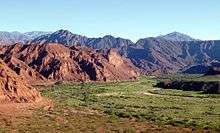
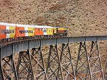
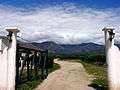
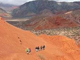
The Tren a las Nubes ("Train to the Clouds") crosses canyons and cliffs before arriving at the 3,775 metres altitude (12,500 feet) of San Antonio de los Cobres. The red-rock formations of the Valles Calchaquíes and the wine-town of Cafayate are the second most visited place in the province. Many visit the Cachi mountains and the villages (such as Payogasta) around it.
There are three national parks in Salta: El Rey National Park in the Yungas jungle, Baritú National Park and Los Cardones National Park.

Demographics
| Historical population | ||
|---|---|---|
| Year | Pop. | ±% |
| 1869 | 88,933 | — |
| 1895 | 118,015 | +32.7% |
| 1914 | 142,156 | +20.5% |
| 1947 | 230,445 | +62.1% |
| 1960 | 412,854 | +79.2% |
| 1970 | 509,803 | +23.5% |
| 1980 | 662,870 | +30.0% |
| 1991 | 866,153 | +30.7% |
| 2001 | 1,079,051 | +24.6% |
| 2010 | 1,214,441 | +12.5% |
| Source: [15] | ||
According to the results from the 2010 census [INDEC], the province has a population of 1,214,441.[15] It constitutes 3.0% of the total population in Argentina.[16]:63 This represented a 12.5% increase in the population compared to 2001 census [INDEC] which had 1,079,051 inhabitants.[17] 6.5% of the population or 79,204 persons declared themselves as having Indigenous background,[18]:69 making it one of the provinces that has a high percentage of indigenous people, being ranked 5th behind Chubut, Neuquén, Jujuy and Río Negro.[16]:278 The most populous indigenous groups in the province are the Wichí, which make up 24.9% of the total indigenous population followed by the Kolla (21.6%), and the Guaraní (13.7%).[18]:69 As well, 4,189 persons declared themselves to be Afro-Argentine.[19] Most of Salta people is of Criollo background.

The province hosts a diverse foreign community: Christian Levantines of Syrian-Lebanese origin, Spaniards and Italians make up the largest groups. A small Ukrainian community has been there since the collapse of the Soviet Union and an Indian Sinkh community has been living in Rosario de la Frontera since the 1940s. Other foreign people settled in the province are the Greek Cypriots, the Chinese, the Germans, the Francs, the Chileans, the Bolivians, the Paraguayans and the Slavs from the Adriatic (mainly Serbs and Croats). The Jewish community has a synagogue and the Muslims have a mosque, both in Salta City.
Politics
The province is governed as representative and republican form of government.[4]:14 The provincial government is divided into three branches: the executive, headed by a popularly elected governor, who appoints the cabinet; the legislative; and the judiciary, headed by the Supreme Court.
The Constitution of Salta Province forms the formal law of the province.
In Argentina, the most important law enforcement organization is the Argentine Federal Police but the additional work is carried out by the Salta Provincial Police.
Political division

The province is divided in 23 departments (Spanish: departamentos), containing 59 municipalities (Spanish: municipios).[20] The capital of the province is the city of Salta, which is where the provincial government is located at.[20]
| Map | Departament | Area[4]:31–33 | Population (2010 Census)[21] | Towns and municipalities (in bold: department capital)[4]:31–33 |
|---|---|---|---|---|
.png) |
Anta | 21,945 km2 (8,473 sq mi) | 57,411 | Apolinario Saravia El Quebrachal General Pizarro Joaquín Víctor González Las Lajitas |
.png) |
Cachi | 2,925 km2 (1,129 sq mi) | 7,315 | Cachi Payogasta |
.png) |
Cafayate | 1,570 km2 (610 sq mi) | 14,850 | Cafayate |
.png) |
Capital | 1,722 km2 (665 sq mi) | 536,113 | Salta Villa San Lorenzo |
.png) |
de Cerrillos | 640 km2 (250 sq mi) | 35,789 | Cerrillos La Merced |
.png) |
Chicoana | 910 km2 (350 sq mi) | 20,710 | Chicoana El Carril |
.png) |
General Güemes | 2,365 km2 (913 sq mi) | 47,226 | Campo Santo El Bordo General Güemes |
.png) |
General San Martín | 16,257 km2 (6,277 sq mi) | 156,910 | Aguaray Embarcación General Ballivián General Mosconi Salvador Mazza Tartagal |
.png) |
Guachipas | 2,785 km2 (1,075 sq mi) | 3,187 | Guachipas |
.png) |
Iruya | 3,515 km2 (1,357 sq mi) | 5,987 | Iruya Isla de Cañas |
.png) |
La Caldera | 867 km2 (335 sq mi) | 7,763 | La Caldera Vaqueros |
.png) |
La Candelaria | 1,525 km2 (589 sq mi) | 5,704 | El Jardín El Tala La Candelaria |
.png) |
La Poma | 4,447 km2 (1,717 sq mi) | 1,738 | La Poma |
.png) |
La Viña | 2,152 km2 (831 sq mi) | 7,435 | Coronel Moldes La Viña |
.png) |
Los Andes | 25,951 km2 (10,020 sq mi) | 6,050 | San Antonio de los Cobres Tolar Grande |
.png) |
Metán | 5,235 km2 (2,021 sq mi) | 40,351 | El Galpón San José de Metán Río Pîedras |
.png) |
Molinos | 3,600 km2 (1,400 sq mi) | 5,652 | Molinos Seclantás |
.png) |
Orán | 11,892 km2 (4,592 sq mi) | 138,838 | Colonia Santa Rosa Hipólito Yrigoyen Pichanal San Ramón de la Nueva Orán Urundel |
.png) |
Rivadavia | 25,951 km2 (10,020 sq mi) | 30,357 | Rivadavia Banda Norte Rivadavia Banda Sur Santa Victoria Este |
.png) |
Rosario de la Frontera | 5,402 km2 (2,086 sq mi) | 28,993 | El Potrero Rosario de la Frontera |
.png) |
Rosario de Lerma | 5,110 km2 (1,970 sq mi) | 38,702 | Campo Quijano Rosario de Lerma |
.png) |
San Carlos | 5,125 km2 (1,979 sq mi) | 7,016 | Angastaco Animaná San Carlos |
.png) |
Santa Victoria | 3,912 km2 (1,510 sq mi) | 10,344 | Los Toldos Nazareno Santa Victoria Oeste |


References
- "Censo 2010 Argentina resultados provisionales: mapas". 200.51.91.231. Archived from the original on 2012-09-01. Retrieved 2014-04-22.
- "Información para el desarrollo sostenible: Argentina y la Agenda 2030" (PDF) (in Spanish). United Nations Development Programme. p. 155. Archived from the original (PDF) on 25 August 2017. Retrieved 25 August 2017.
- Parker, William Belmont (1920). Argentines of today. Volume 5 of Hispanic Notes and Monographs. 2 (Digitized May 22, 2008 ed.). New York: The Hispanic Society of America. pp. 637–640.
- "Anuario Estadístico Año 2015–Avance 2016" (PDF) (in Spanish). Dirección General de Estadísticas de Salta. Archived from the original (PDF) on 5 February 2018. Retrieved 5 February 2018.
- "La Fiesta del Fe - Salta´s Massive Pilgrimmage [sic]". 19 September 2001. Retrieved 2016-01-11.
- "Clima de la Provincia de Salta" (in Spanish). Portal Informativo de Salta. Retrieved 15 December 2015.
- "Información del Clima" (in Spanish). Ministerio de Cultura y Turismo de la Provincia de Salta. Retrieved 15 December 2015.
- Bobba, María (2011). "Causas de Las Sequías de la Región del NOA (Argentina)". Retrieved 26 July 2015.
- Ahumada, Ana (2002). "Periglacial phenomena in the high mountains of northwestern Argentina" (PDF). South African Journal of Science. 98: 166–170. Retrieved 26 July 2015.
- "The Vegetation of Northwestern Argentina". The University of Western Ontario. Archived from the original on 9 March 2016. Retrieved 15 December 2015.
- "El déficit consolidado de las provincias rondará los $11.500 millones este año" (in Spanish). Instituto Argentino para el Desarrollo de las Economías Regionales. Retrieved 10 July 2015.
- "Producto Bruto Geográfico–Provincia de Salta" (PDF) (in Spanish). Dirección General de Estadísticas de la Provincia de Salta. Retrieved 10 July 2015.
- The average exchange for 1 US dollar was 4.54 Argentine pesos in 2012 according to the World Bank
- "Train to the clouds - ARGENTINEAN NORTH". Trenalasnubes.com.ar. Retrieved 2014-04-22.
- "Evolución de la población en los Censos Nacionales de 1869, 1895, 1914, 1947, 1960, 1970, 1980, 1991, 2001 y 2010. Provincia de Salta, según departamento" (in Spanish). Dirección General de Estadísticas de la Provincia de Salta. Retrieved 15 December 2015.
- "Censo Nacional de Población, Hogares y Viviendas 2010: Resultados definitivos: Serie B No 2: Tomo 1" (PDF) (in Spanish). INDEC. Retrieved 15 December 2015.
- "Población censada en 2001 y 2010 y variación intercensal absoluta y relativa 2001-2010. Provincia de Salta, según departamento" (in Spanish). Dirección General de Estadísticas de la Provincia de Salta. Retrieved 15 December 2015.
- "Censo Nacional de Población, Hogares y Viviendas 2010: Pueblos Originarios: Región Noroeste Argentino: Serie D No 1" (PDF) (in Spanish). INDEC. Retrieved 16 December 2015.
- "Cuadro P42-P. Provincia de Salta. Población afrodescendiente en viviendas particulares por sexo, según grupo de edad. Año 2010" (PDF) (in Spanish). INDEC. Retrieved 15 December 2015.
- "Salta–División Política" (in Spanish). Portal Informativo de Salta. Archived from the original on 5 February 2018. Retrieved 5 February 2018.
- "Cuadrp P1-P. Provincia de Salta. Población total y variación intercensal absoluta y relativa por departamento. Años 2001-2010" (PDF) (in Spanish). INDEC. Retrieved 5 February 2018.
External links
| Wikimedia Commons has media related to: |
| Wikisource has the text of a 1905 New International Encyclopedia article about Salta Province. |
- (in Spanish) Salta Province official website
- (in Spanish) Salta Province official portal
- (in Spanish) Tourist Secretary
- (in Spanish) Salta.com
- (in Spanish) Nuevo Diario de Salta
- (in Spanish) Universidad Nacional de Salta
- (in Spanish) Welcome Salta

| Authority control |
|
|---|