Dolores, Buenos Aires
Dolores is a town in Buenos Aires Province, Argentina. It is the administrative centre for Dolores Partido. The town settlement was officially founded by Ramón Lara on 21 August 1817.
Dolores | |
|---|---|
Town | |
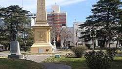 Plaza Castelli, central square of Dolores | |
 Seal | |
| Coordinates: 36°19′S 57°40′W | |
| Country | |
| Province | |
| Partido | Dolores |
| Founded | 21 August 1817 |
| Elevation | 6 m (20 ft) |
| Population | |
| • Total | 25,940 |
| CPA Base | B 7100 |
| Area code(s) | +54 2245 |
2008 March train disaster
On March 9, 2008 an intercity bus from the company El Rápido Argentino collided with a Ferrobaires passenger train with 250 passengers on board at a level crossing on the Provincial Highway 63 on the outskirts of Dolores, killing seventeen people and injuring at least twenty-five. The bus driver disregarded the railroad crossing signals, which at the time of the accident were operating properly.[1]
Climate
| Climate data for Dolores, Buenos Aires (1981–2010, extremes 1961–present) | |||||||||||||
|---|---|---|---|---|---|---|---|---|---|---|---|---|---|
| Month | Jan | Feb | Mar | Apr | May | Jun | Jul | Aug | Sep | Oct | Nov | Dec | Year |
| Record high °C (°F) | 40.0 (104.0) |
36.8 (98.2) |
38.2 (100.8) |
33.0 (91.4) |
29.7 (85.5) |
27.3 (81.1) |
30.2 (86.4) |
31.5 (88.7) |
31.7 (89.1) |
31.7 (89.1) |
34.7 (94.5) |
39.7 (103.5) |
40.0 (104.0) |
| Average high °C (°F) | 28.6 (83.5) |
27.4 (81.3) |
25.6 (78.1) |
21.6 (70.9) |
17.9 (64.2) |
14.3 (57.7) |
13.6 (56.5) |
15.9 (60.6) |
17.5 (63.5) |
21.0 (69.8) |
23.8 (74.8) |
27.0 (80.6) |
21.2 (70.2) |
| Daily mean °C (°F) | 21.8 (71.2) |
20.8 (69.4) |
19.0 (66.2) |
15.1 (59.2) |
11.6 (52.9) |
8.7 (47.7) |
7.8 (46.0) |
9.8 (49.6) |
11.7 (53.1) |
14.9 (58.8) |
17.6 (63.7) |
20.3 (68.5) |
14.9 (58.8) |
| Average low °C (°F) | 15.2 (59.4) |
14.7 (58.5) |
13.3 (55.9) |
9.6 (49.3) |
6.8 (44.2) |
4.4 (39.9) |
3.9 (39.0) |
5.1 (41.2) |
6.4 (43.5) |
9.6 (49.3) |
11.7 (53.1) |
13.6 (56.5) |
9.5 (49.1) |
| Record low °C (°F) | −0.7 (30.7) |
1.9 (35.4) |
0.5 (32.9) |
−4.2 (24.4) |
−5.6 (21.9) |
−9.6 (14.7) |
−7.2 (19.0) |
−6.9 (19.6) |
−5.8 (21.6) |
−2.7 (27.1) |
−2.4 (27.7) |
−0.6 (30.9) |
−9.6 (14.7) |
| Average precipitation mm (inches) | 108.4 (4.27) |
99.8 (3.93) |
90.4 (3.56) |
97.4 (3.83) |
58.7 (2.31) |
59.9 (2.36) |
59.6 (2.35) |
59.0 (2.32) |
66.8 (2.63) |
102.1 (4.02) |
108.7 (4.28) |
83.9 (3.30) |
994.7 (39.16) |
| Average precipitation days (≥ 0.1 mm) | 8.3 | 8.1 | 8.4 | 7.9 | 7.2 | 7.4 | 7.2 | 6.7 | 8.0 | 9.7 | 9.4 | 8.3 | 96.6 |
| Average relative humidity (%) | 73.5 | 77.2 | 79.8 | 81.5 | 83.4 | 84.9 | 84.0 | 81.3 | 79.7 | 77.6 | 75.3 | 72.0 | 79.2 |
| Mean monthly sunshine hours | 266.6 | 214.7 | 186.0 | 177.0 | 142.6 | 105.0 | 114.7 | 158.1 | 171.0 | 204.6 | 237.0 | 248.0 | 2,225.3 |
| Mean daily sunshine hours | 8.6 | 7.6 | 6.0 | 5.9 | 4.6 | 3.5 | 3.7 | 5.1 | 5.7 | 6.6 | 7.9 | 8.0 | 6.1 |
| Source 1: Servicio Meteorológico Nacional (September precipitation days 1961–1990)[2][3][4][5] | |||||||||||||
| Source 2: Deutscher Wetterdienst (sun 1961–1990)[6] | |||||||||||||
Gallery
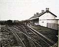 Train station (1880s)
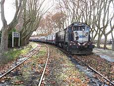 Train station (2007)
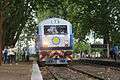 Train station (2014)
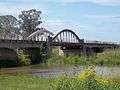 Old bridge
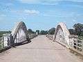 Old bridge (Route 2)
References
- "18 killed when bus and train collide". Herald Sun. 2008-03-10. Retrieved 2008-03-31.
- "Estadísticas Climatológicas Normales - período 1981-2010" (in Spanish). Servicio Meteorológico Nacional. Retrieved 24 April 2018.
- "Pronóstico Extendido por Dolores–Estadísticas Normales Mensuales Estación: Dolores Aero" (in Spanish). Servicio Meteorológico Nacional. Retrieved 24 April 2018.
- "Valores Medios de Temperatura y Precipitación-Buenos Aires: Dolores" (in Spanish). Servicio Meteorológico Nacional. Retrieved 23 January 2016.
- "Clima en la Argentina: Guia Climática por Dolores Aero". Caracterización: Estadísticas de largo plazo (in Spanish). Servicio Meteorológico Nacional. Archived from the original on 7 February 2019. Retrieved 7 October 2017.
- "Klimatafel von Dolores, Prov. Buenos Aires / Argentinien" (PDF). Baseline climate means (1961-1990) from stations all over the world (in German). Deutscher Wetterdienst. Retrieved 23 January 2016.
External links
Municipal information: Municipal Affairs Federal Institute (IFAM), Municipal Affairs Secretariat, Ministry of Interior, Argentina. (in Spanish)
- (in Spanish) Dolores website
- Municipal website
- Dolores Aeroclub
- Dos Ombúes - Turismo Natural & Cultural
- No a la tala - Group for a healthy and sustainable
- Dolores LiveArgentina
This article is issued from Wikipedia. The text is licensed under Creative Commons - Attribution - Sharealike. Additional terms may apply for the media files.