Pillaiyarkuppam, Bahour
Pillaiyarkuppam is a village[1] in Bahour Commune of Bahour taluk in the Union Territory of Puducherry, India. It lies 2 km east of NH-45A.
Pillaiyarkuppam | |
|---|---|
Village | |
 Pillaiyarkuppam Location in Puducherry, India  Pillaiyarkuppam Pillaiyarkuppam (India) | |
| Coordinates: 11.811908°N 79.792199°E | |
| Country | |
| State | Puducherry |
| District | Pondicherry |
| Taluk | Bahour |
| Commune | Bahour |
| Languages | |
| • Official | French, Tamil, English |
| Time zone | UTC+5:30 (IST) |
| PIN | 607 402 |
| Telephone code | 0413 |
| Vehicle registration | PY-01 |
| Sex ratio | 50% ♂/♀ |
Geography
Pillaiyarkuppam is bordered by Kudiyiruppupalayam in the west, Kirumampakkam in the north, Bay of Bengal in east and Manappattu in the south.
Road Network
Pillaiyarkuppam is connected to Puducherry by Narambai road which branches off at the 51th km. of NH-45A. Also Pannithittu-Pudukuppam road passes through Pillaiyarkuppam.
Villages
Following are the list of villages under Pillaiyarkuppam Village Panchayat.
- Pillaiyarkuppam
- Kandanpet
- Narambai
- Valluvarmedu
Gallery
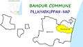 Map of Pillaiyarkuppam Village Panchayat
 Pillayarkuppam Village Panchayat Office, Bahour Commune
Resort
Zest Big Beach, Puducherry
Zest Big Beach,[2] A Mahindra group Company is located at Pillaiyarkuppam beach. It provides variety of adventurous activities.
Politics
Pillaiyarkuppam is a part of Embalam (Union Territory Assembly constituency) which comes under Puducherry (Lok Sabha constituency)
References
- "Archived copy" (PDF). Archived from the original (PDF) on 27 September 2013. Retrieved 17 March 2013.CS1 maint: archived copy as title (link)
- http://www.zestbreaks.com/destination/Puducherry/Pages/Puducherry.aspx