Parikkalpattu
Parikkalpattu is a village[1] in Bahour Commune of Bahour taluk in the Union Territory of Puducherry, India. It lies on southern border of Bahour Enclave of Puducherry district.
Parikkalpattu | |
|---|---|
Village | |
 Parikkalpattu Location in Puducherry, India  Parikkalpattu Parikkalpattu (India) | |
| Coordinates: 11.792815°N 79.751623°E | |
| Country | |
| State | Puducherry |
| District | Pondicherry |
| Taluk | Bahour |
| Commune | Bahour |
| Population (2001) | |
| • Total | 36,983 |
| Languages | |
| • Official | French, Tamil, English |
| Time zone | UTC+5:30 (IST) |
| PIN | 607 402 |
| Telephone code | 0413 |
| Vehicle registration | PY-01 |
| Sex ratio | 50% ♂/♀ |
Geography
Parikkalpattu is bordered by Kuruvinatham, Soriyankuppam in the west, Bahour in the north, Kanganakuppam village of Tamil nadu in the east and Pennaiyar River in the south.
Road Network
Parikkalpattu is connected to Bahour, its Commune Headquarters via Bahour-Parikkalpattu road. PRTC ply town bus to Parikkalpattu. But they are less frequent.
Villages
Following are the list of villages under Parikkalpattu Village Panchayat.
- Mel Parikkalpattu
- Keezh Parikkalpattu
- Periya Archatchikuppam
- Chinna Archatchikuppam
- Kumandhanmedu
Gallery
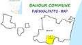 Map of Parikkalpattu Village Panchayat
 Government Branch Library, Parikkalpattu Bahour Commune
Politics
Parikkalpattu is a part of Bahour (Union Territory Assembly constituency) which comes under Puducherry (Lok Sabha constituency)
References
- "Archived copy" (PDF). Archived from the original (PDF) on 27 September 2013. Retrieved 17 March 2013.CS1 maint: archived copy as title (link)
This article is issued from Wikipedia. The text is licensed under Creative Commons - Attribution - Sharealike. Additional terms may apply for the media files.