Bahour (East)
Bahour (East) is a Village in Commune in the Union Territory of Puducherry, India. It consists of few areas of Bahour and the entire part of Bahourpet.
Bahour(East) | |
|---|---|
Village | |
 Bahour(East) Location in Puducherry, India  Bahour(East) Bahour(East) (India) | |
| Coordinates: 11.806489°N 79.745378°E | |
| Country | |
| State | Puducherry |
| District | Puducherry |
| Population (2001) | |
| • Total | 36,983 |
| Languages | |
| • Official | French, Tamil, English |
| Time zone | UTC+5:30 (IST) |
| PIN | 607 402 |
| Telephone code | 0413 |
| Vehicle registration | PY-01 |
| Sex ratio | 50% ♂/♀ |
Geography
Bahour (East) is bordered by Bahour(West) in the west, Kudiyiruppupalayam in the north, Manapattu, Krishnavaram in the east and Parikkalpattu in the south.
Road Network
Kanniakoil–Bahour Road (RC-28) passes through Bahour(East). This road connects Bahour with National Highways-45A.
Gallery
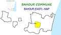 Map of Bahour(East) Village Panchayat
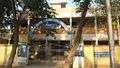 Government Primary School, Bahour Pet
References
This article is issued from Wikipedia. The text is licensed under Creative Commons - Attribution - Sharealike. Additional terms may apply for the media files.