Pannithittu
Pannithittu is a village[1] in Bahour Commune of Bahour taluk in the Union Territory of Puducherry, India. It lies east of NH-45A at a distance of 2 km from it. River Malattar joins Bay of Bengal at Pannithittu.
Pannithittu | |
|---|---|
Village | |
 Pannithittu Location in Puducherry, India  Pannithittu Pannithittu (India) | |
| Coordinates: 11.828668°N 79.802295°E | |
| Country | |
| State | Puducherry |
| District | Pondicherry |
| Taluk | Bahour |
| Commune | Bahour |
| Languages | |
| • Official | French, Tamil, English |
| Time zone | UTC+5:30 (IST) |
| PIN | 607 402 |
| Telephone code | 0413 |
| ISO 3166 code | IN-WB |
| Vehicle registration | PY-01 |
| Sex ratio | 50% ♂/♀ |
Geography
Pannithittu is bordered by Kirumampakkam in the west, Malattar in the north, Bay of Bengal in east and Pillaiyarkuppam in the south.
Villages
Following are the villages under Pannithittu Village Panchayat.
- Pannithittu
- Aladimedu
- Etchangadu
- Vambapet
Road network
Pannithittu is connected to Puducherry by NH45A - Kirumampakkam road. Also Pannithittu is connected to Pudukuppam via. Pillaiyarkuppam, Bahour and Manappattu. There is also an access road from Reddichavadi via Pannithittu Regulator.
Gallery
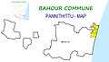 Map of Pannithittu Village Panchayat
 Government High School, Panniththittu, Bahour Commune
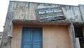 Government Branch Library, Panniththittu, Bahour Commune
Politics
Pannithittu is a part of Embalam (Union Territory Assembly constituency) which comes under Puducherry (Lok Sabha constituency)
References
- "Archived copy" (PDF). Archived from the original (PDF) on 27 September 2013. Retrieved 17 March 2013.CS1 maint: archived copy as title (link)