Madikeri
Madikeri (also known by its former name Mercara) is a hill station town in Madikeri taluk in Karnataka state, India. It is the headquarters of the district of Kodagu.
Madikeri Mercara | |
|---|---|
Town | |
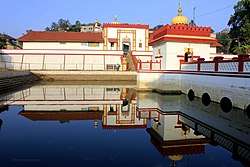 Omkareshwara Temple | |
 Madikeri Location in Karnataka, India  Madikeri Madikeri (India) | |
| Coordinates: 12.4209°N 75.7397°E | |
| Country | |
| State | Karnataka |
| District | Kodagu |
| Region | Coorg, Malnad |
| Elevation | 1,150 m (3,770 ft) |
| Population (2011) | |
| • Total | 33,381 |
| Languages | |
| • Administrative | Kannada |
| • Regional | Kodava, Arebhashe |
| Time zone | UTC+5:30 (IST) |
| PIN | 571 201 |
| Telephone code | 08272 |
| Vehicle registration | KA-12 |
| Website | www |
Etymology
Madikeri was known as Muddu Raja Keri,[1] which meant Mudduraja's town, was named after the prominent Haleri king Mudduraja who ruled Kodagu from 1633 to 1687. From 1834, during the British Raj, it was called Mercara. It was later renamed to Madikeri by the Government of Mysore.
History
The history of Madikeri is related to the history of Kodagu. From the 2nd to the 6th century AD, the northern part of Kodagu was ruled by Kadambas. The southern part of Kodagu was ruled by Gangas from the 4th to the 11th century. After defeating the Gangas in the 11th century, Cholas became the rulers of Kodagu. In the 12th century, the Cholas lost Kodagu to the Hoysalas. Kodagu fell to the Vijayanagar kings in the 14th century. After their fall, the local chieftains like Karnambahu (Palegars) started ruling their areas directly. They were defeated by Haleri Dynasty founder Veeraraju, (Nephew of Ikkeri Sadashiva Nayaka who were descendants of Talakadu Ganga Dynasty),. In the year 1700AD Ikkeri Somashekara Nayaka gifted Puttur and Amara Sullia Magnes of Tulunadu to Haleri Kings. Descendants of Veeraraju who are known as "Haleri Dynasty" ruled Kodagu from 1600-1834 AD. Haleri king Mudduraja built the Fort in Madikeri and made it[2] as their capital. Mudduraja, the third Haleri king started leveling the land around Madikeri and built a fort in the year 1681. Madikeri Fort which was original built of mud and was replaced by Tipu Sultan. Kodagu became the part of British India after 1834 AD.[3]
Demographics
As of 2011 India census,[4] Madikeri had a population of 33,381. Males constitute 57.2% of the population and females 42.8%. Madikeri had an average literacy rate of 85%, higher than the national average of 57.2: male literacy was 83%, and female literacy 80%. 11% of the population was under 6 years of age. This town is situated at an elevation of over 3770 ft above sea level.
Geography and climate
Madikeri features a tropical highland climate as it has an elevation of 1150 metres (3838 feet). Madikeri is located at 12.42°N 75.73°E.[5][6] Madikeri lies in the Western Ghats and is a popular hill station. The nearest cities are Hassan to the north, Mangaluru to the west, and Mysuru to the east.
The mean daily minimum temperature is lowest in January at about 11 °C. Maximum temperature in summer is around 24 °C to 27 °C.[7] With the onset of the south-west monsoon, the temperature decreases in June and the weather becomes chilly. The lowest temperature recorded is 4.5 °C.
| Climate data for Madikeri (1981–2010, extremes 1901–2012) | |||||||||||||
|---|---|---|---|---|---|---|---|---|---|---|---|---|---|
| Month | Jan | Feb | Mar | Apr | May | Jun | Jul | Aug | Sep | Oct | Nov | Dec | Year |
| Record high °C (°F) | 31.7 (89.1) |
32.1 (89.8) |
34.2 (93.6) |
34.2 (93.6) |
35.0 (95.0) |
32.2 (90.0) |
28.9 (84.0) |
31.0 (87.8) |
30.0 (86.0) |
30.3 (86.5) |
28.5 (83.3) |
29.0 (84.2) |
35.0 (95.0) |
| Average high °C (°F) | 26.4 (79.5) |
28.2 (82.8) |
29.8 (85.6) |
29.4 (84.9) |
27.5 (81.5) |
23.3 (73.9) |
21.6 (70.9) |
21.6 (70.9) |
23.6 (74.5) |
25.0 (77.0) |
25.3 (77.5) |
25.3 (77.5) |
25.6 (78.1) |
| Average low °C (°F) | 12.4 (54.3) |
13.1 (55.6) |
15.0 (59.0) |
17.5 (63.5) |
18.1 (64.6) |
17.6 (63.7) |
17.2 (63.0) |
17.2 (63.0) |
17.1 (62.8) |
16.9 (62.4) |
15.6 (60.1) |
13.2 (55.8) |
15.9 (60.6) |
| Record low °C (°F) | 4.8 (40.6) |
5.1 (41.2) |
7.6 (45.7) |
10.6 (51.1) |
9.4 (48.9) |
9.2 (48.6) |
8.8 (47.8) |
9.5 (49.1) |
10.0 (50.0) |
10.6 (51.1) |
7.9 (46.2) |
5.5 (41.9) |
4.8 (40.6) |
| Average rainfall mm (inches) | 1.6 (0.06) |
3.0 (0.12) |
15.0 (0.59) |
65.3 (2.57) |
128.7 (5.07) |
646.3 (25.44) |
952.5 (37.50) |
821.0 (32.32) |
274.7 (10.81) |
211.0 (8.31) |
70.8 (2.79) |
20.0 (0.79) |
3,210 (126.38) |
| Average rainy days | 0.2 | 0.3 | 1.6 | 5.0 | 7.8 | 22.2 | 27.0 | 26.2 | 16.2 | 12.2 | 4.4 | 1.1 | 124.1 |
| Average relative humidity (%) (at 17:30 IST) | 58 | 55 | 57 | 69 | 77 | 90 | 93 | 93 | 88 | 83 | 74 | 65 | 76 |
| Source: India Meteorological Department[8][9] | |||||||||||||
See also
- Hassan
- Kodagu Institute of Medical Sciences
- Mangalore
- Sakleshpur
- Kodava
- Talakaveri
References
- Coorg History Archived 2009-04-26 at the Wayback Machine
- Puttur Anantharaja Gowda (2015). IN PURSUIT OF OUR ROOTS.
- Jerry Dupont, The Common Law Abroad, Wm. S. Hein Publishing, 2001, ISBN 0-8377-3125-9, from p 592
- "Census of India 2001: Data from the 2001 Census, including cities, villages and towns (Provisional)". Census Commission of India. Archived from the original on 16 June 2004. Retrieved 1 November 2008.
- Madikeri, FallingRain.com
- "Maps, Weather, and Airports for Madikeri, India". www.fallingrain.com.
- Ground Water Information Booklet, Ministry of Water Resources, 2007. Retrieved 23 June 2011.
- "Station: Madikeri/Mercara Climatological Table 1981–2010" (PDF). Climatological Normals 1981–2010. India Meteorological Department. January 2015. pp. 489–490. Archived from the original (PDF) on 5 February 2020. Retrieved 19 April 2020.
- "Extremes of Temperature & Rainfall for Indian Stations (Up to 2012)" (PDF). India Meteorological Department. December 2016. p. M99. Archived from the original (PDF) on 5 February 2020. Retrieved 19 April 2020.
External links
| Wikimedia Commons has media related to Madikeri. |

- Madikeri.org: Portal on Madikeri and Coorg
- Madikeri: History and Architecture