Paseo de Tacón
The Paseo de Tacón, or Paseo Militar, was created by the Captain General (Spanish: Capitanía General de Cuba) Miguel Tacón y Rosique (1834–1838)[lower-alpha 1] who promoted the reform of the “road” that, starting from the calles of San Luis de Gonzaga (Reina)[lower-alpha 2] and Belascoáin, connected to the Castillo del Príncipe. Calle Belascoáin was the edge between the city and the countryside.[2]
| Paseo de Tacón | |
|---|---|
 | |
| |
| Former names | “Paseo Militar”, “Avenida de la Independencia” |
| Alternative names | “Salvador Allende” |
| General information | |
| Type | Promenade |
| Architectural style | Neoclassical |
| Location | Avenida Salvador Allende |
| Town or city | |
| Country | |
| Coordinates | 23.1310°N 82.3744°W |
History
.jpg)
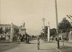
Avenida Carlos III, was a promenade that Captain General (Spanish: Capitanía General de Cuba) Miguel Tacón y Rosique, put into operation in 1836. When first created, it was called the Paseo de Tacón. Years later, the name was changed to Carlos III in honor of the King of Spain, a statue of the king was erected. Avenida de Carlos III begins at the intersection with the Ayestarán and Presidente Menocal or Calle Infanta.[3]
The beautification plan of Havana by the engineer Mariano Carrillo de Albornoz during the third decade of the nineteenth century, contemplated the construction of s comfortable and beautiful walk that would serve for the recreation of the city's residents who were already spreading to more and more of its original city limits and as framed by the original wall that protected them from foreign attacks.[3]
The Paseo de Tacón would allow for better communication with the colonial troops in the Castillo del Príncipe, because until then it was difficult to reach that military installation by having to circumvent a low and muddy road that became practically impassable in times of rains.[3]
Tacon said about this project:
“It lacked the capital of a country walk where you could breathe the pure and free air, and I resolved to undertake it from the field that they call from Peñalver to the hillside where the Prince's castle is located. It was this site, once swampy and watery, the most on purpose for a work of this kind in the surroundings of this city, in the part where it is not surrounded by the sea. There was also another reason that turned the work into doubly useful, which was the frank communication of this square with the castle, interrupted by that part in the rainy season. ”[2]
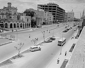
Well-known since the time of the monarchy by the name Carlos III, the street is more than 50 meters in width and serves to direct traffic to and from the oldest areas of Havana. It has four lanes of traffic it is the widest traffic artery in the city.[3]
Quinta de los Molinos
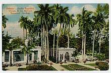
La Quinta de los Molinos is a botanical gaden and a national monument located in the general vecinity of the Paseo de Tacón. Important for having been the residence of the Captaincy General of Cuba during the colonial period. It was also the residence of Cuba's first president Máximo Gómez, (November 18, 1836 – June 17, 1905) who was a Major General in Cuba's Ten Years' War (1868–1878) against Spain. He was also Cuba's military commander in that country's War of Independence (1895–1898). There is also the Botanical Garden of Havana and the Máximo Gómez Museum.
History
It is called La Quinta de los Molinos due to the existence of 2 grinding mills used for tobacco and snuff, in high demand at the end of the 18th century throughout Europe, and particularly in Spain. The mills were owned by Martín de Aróstegui, president of the Royal Tobacco Factory belonging to the Spanish king, hence his name. The name appears in the National Archive in 1850 and remains until today. before 1850, it was known as El Jardin de Tacon as it appears in a plan from 1843 and on a marble plate embedded in the wall of an old building there.
The mills worked until the second half of the 19th century, they were moved by the force of water from the Royal Trench which was the first aqueduct in Havana. Its construction began in 1592, and they were finished after 27 years of work. Very close to the Plaza de La Catedral is the alley of the jet, whose name comes from its old use. Originally the Plaza de la Catedral was called Plaza de la Ciénaga, since it was there where the Havanans came to get water, brought by the Royal Ditch. The jet as the Zanja Real was also known, more than 11 km long, started from the Almendares River and brought water to Havana across the Zanja street that bears that name in honor of it. This first aqueduct was discontinued when, given the growing development of the city, the Spanish government was forced to find another solution for the water supply to the city, creating the aqueduct of Fernando VII in 1835, and the Acueducto de Albear in 1858, which joined in 1878.
The original extension of the Quinta de los Molinos far exceeded the current territory, since it extended north to approximately the location of the University of Havana, northwest to the current Calixto Garcia Hospital originally founded under the name of Alfonso VIII in 1896; west to the current Calle G including the Castillo del Príncipe, south to the present Salvador Allende Avenue (Avenida Carlos III ) and east to Infanta Street.
In 1607 Philip III created the Captaincy General of Cuba as part of larger plans to defend the Caribbean against foreign threats. The first Captain General was Pedro Valdés. Around the same time other captaincies general were established in Puerto Rico (1580) and Central America (1609). Cuba was divided into two governorships with capitals in Havana and Santiago de Cuba. The governor of Havana was Captain General of the island. In 1650 Cuba received a large influx of refugees when the British conquered Jamaica and expelled the Spanish residents there.[4]
In 1756 the construction of ships for the Spanish Navy began with the establishment of an Intendancy of the Navy was established in Havana, which functioned as a royal shipyard.
The British conquest of the island in 1762 during the Seven Years' War proved to be a turning point in the history of Cuba and Spanish America in general. The British captured Havana after a three-month siege and controlled the western part of the island for a year. Britain returned Cuba in exchange for Florida in the Treaty of Paris (1763). The events revealed not only the weaknesses of the region's defenses but also proved just how much the Cuban economy had been neglected by the Spanish. During the year they controlled Cuba, the British conducted an unprecedented amount of trade with the island.[5] A year earlier France had secretly ceded Louisiana to Spain in compensation for its losses as its ally during the war.[6]
As a sign of the seriousness with which the government took the problems, the very year the Spanish retook control of Havana construction began on what would become the largest Spanish fort in the New World, San Carlos de la Cabaña on the eastern side of the entrance to harbor of Havana.[6]
See also
Notes
- Miguel Tacón y Rosique ( Cartagena , January 10, 1775 - Madrid , October 12, 1855 ) First Marquis of the Union of Cuba, (later elevated to Duchy), Duke of the Union of Cuba , was a nobleman, sailor and Spanish military , Lieutenant General of the Royal Navy , Field Marshal of the Army of Earth and I Duke of the Union of Cuba .
- The street is eleven blocks and runs from Calle Amistad to Belascoaín. It was originally called Camino de San Luis Gonzaga; later, people called it El Mentidero, place for liars, because politicians used to give speeches here. After being renovated in 1844, the street was renamed Calle Reina in honor of Queen Isabel II. In 1918, it was renamed as Avenida Bolívar, but Habaneros keep calling it Calle Reina. There are notable colonial houses on Calle Reina. There are Art Nouveau buildings, the Cetro de Oro, the Golden Scepter, and Casa Crusellas.. At the corner with Gervasio Street is the Iglesia Sagrado Corazón de Jesús built by the Jesuits between 1914 and 1923.[1]
References
- "Calle Reina". Retrieved 2020-01-20.
- Numa, Lázaro. "Andar tras las huellas de Tacón". Retrieved 2020-01-28.
- "AVENIDA DE CARLOS III". Retrieved 2020-01-28.
- Wikipedia contributors, "Máximo Gómez," Wikipedia, The Free Encyclopedia, https://en.wikipedia.org/w/index.php?title=M%C3%A1ximo_G%C3%B3mez&oldid=932971027 (accessed January 29, 2020).
- Thomas, Hugh (1998). Cuba: The Pursuit of Freedom (2nd ed.). New York: Da Capo Press. ISBN 0-306-80827-7.
- Wikipedia contributors, "Captaincy General of Cuba," Wikipedia, The Free Encyclopedia, https://en.wikipedia.org/w/index.php?title=Captaincy_General_of_Cuba&oldid=926241786 (accessed January 29, 2020).