Cerro, Havana
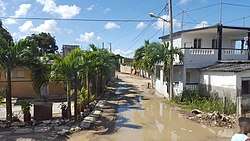
Cerro is one of the 15 municipalities or boroughs (municipios in Spanish) in the city of Havana, Cuba. As of 2016 it is considered "one of Havana’s poorest municipalities."[3]
Cerro | |
|---|---|
Municipality of Havana | |
 | |
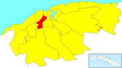 Location of Cerro in Havana | |
| Coordinates: 23°5′17″N 82°23′42″W | |
| Country | |
| Province | |
| Wards (Consejos Populares) | Armada, Cerro, El Canal, Las Cañas, Latinoamericano, Palatino, Pilar-Atares |
| Area | |
| • Total | 10 km2 (4 sq mi) |
| Elevation | 85 m (279 ft) |
| Population (2004)[2] | |
| • Total | 132,351 |
| • Density | 13,235/km2 (34,280/sq mi) |
| Time zone | UTC-5 (EST) |
| Area code(s) | +53-7 |
History
The area dates from 1803 when two property owners José María Rodríguez and Francisco Betancourt established residence. Their example was followed by many others. In 1807, Cerro was recognized as a town with the construction of the first wooden church, which has been replaced by the current parish buildings.
Cerro was chosen by wealthy families of the capital as a place to spend the summer. In 1843 there existed five large vacation residences, with 23 others notable for their sumptuousness. There were also 273 private homes owned by wealthy families. In 1800, Cerro's population was 2,000;[4] 2,125 in 1843; and by 1858, there were 2,530 permanent residents.
References
- Statoids (July 2003). "Municipios of Cuba". Retrieved 2007-10-06.
- Atenas.cu (2004). "2004 Population trends, by Province and Municipality" (in Spanish). Archived from the original on 2006-07-14. Retrieved 2007-10-06.
- Naomi Larsson (September 5, 2016), "Havana's Dirty Truths", The Guardian, Cities
- Sherry Johnson (1997). "'La Guerra Contra los Habitantes de los Arrabales': Changing Patterns of Land Use and Land Tenancy in and around Havana, 1763-1800". Hispanic American Historical Review. 77. JSTOR 2516900.
External links
![]()
Places adjacent to Cerro, Havana | |
|---|---|
Municipalities and wards of Havana | ||
|---|---|---|
| Arroyo Naranjo |
| |
| Boyeros |
| |
| Centro Habana |
| |
| Cerro |
| |
| Cotorro |
| |
| Diez de Octubre |
| |
| Guanabacoa |
| |
| La Habana del Este |
| |
| La Habana Vieja |
| |
| La Lisa |
| |
| Marianao |
| |
| Playa |
| |
| Plaza de la Revolución |
| |
| Regla |
| |
| San Miguel del Padrón |
| |