Paradip
Paradip, also spelt Paradeep (originally Paradweep), is a major seaport city and a municipality in Jagatsinghpur district of Odisha, India. Paradeep Municipality was constituted as an NAC on 27 September 1979 and converted in to Municipality on 12 December 2002.[3] Paradeep (210 15’ 55-44" N 806 40’ 34-62" E) is the main outlet and inlet of the sea-borne trade of the eastern port. It also signaled the economic development of the state, giving impetus to trade and commerce. It has become the gateway of Odisha to the International community. Subsequently, Paradeep has become a hub of industrial activities. Industries like, IFFCO, PPL (a Adventz group company), CARGILL, IOCL, BPCL, HPCL, Carbon etc. have been established here. From administrative view point, Paradeep N.A.C. was constituted vide H & U.D. Department Notification No. 31169, dated 27 September 1979 and became functional with effect from 18 September 1980. Subsequently, Paradeep N.A.C. was upgraded to Municipality under section 424 of Odisha Municipal Act. 1950 vide H. & U.D. Deptt Notification no. 47302/HUD, dated 12 December 2002. The municipality comprises five Revenue Villages namely Udachandrapur, Chauliapalanda, Sandhakuda, Bijayachandrapur, and Bhitaragarh. In view of increasing population and industrialisation, a proposal to include 15 (fifteen) villages i.e. Paradeep Garh, Niharuni, Niharuni Kandha, Chouki Matha, Udayabata, Nimidiha, Kotakula, Rangiagarh, Nua Sandhakud, Musadiha, Musadiha Jangle, Boitarkuda, Kaudia, Aganasi, and Nuagarh has been sent to state H. & U.D. Department on 11 October 2007 and District Collector, Jagatsinghpur for inclusion. Paradip is 94 K.M. from Cuttack and 125 K.M. from Bhubaneswar. Biju Patnaik International Airport is the nearest and only operational commercial airport to reach Paradip.[4]
Paradip | |
|---|---|
  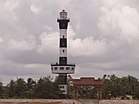  From Top; Left to Right: Paradip Jagannath Temple, Paradeep light House, Paradip Sea Beach and Paradip Port | |
| Nicknames: Smart Industrial Port City [1] | |
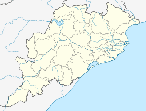 Paradip Location in Odisha, India  Paradip Paradip (India)  Paradip Paradip (Asia) | |
| Coordinates: 20.316°N 86.610°E | |
| Country | |
| State | |
| District | Jagatsinghpur |
| Elevation | 1 m (3 ft) |
| Population (2011[2]) | |
| • Total | 68,585 |
| Demonym(s) | Paradipians |
| Languages | |
| • Official | Odia |
| Time zone | UTC+5:30 (IST) |
| Website | odisha |
History
During early 17th century, Paradip and its adjoining areas were connected with Cuttack through river Mahanadi and its branches. Transportation of goods from rural areas to Cuttack was done through waterways via Dhamara and Pattamundai. But slowly this discontinued due to silting of the river bed. In 1819, the British constructed a sort of a harbour at north of the present Paradip site the then called False Point. In 1862, the East India Irrigation Company explored the potential of Paradip for transportation of rice from the area. The importance of Paradip grew more during the great famine of 1866, when it was used as the main entry point for import of food materials to the famine struck area.
During early post-independent period, a minor port came into existence at Paradip in 1958 through the efforts of the State Government. Subsequently, the Government decided to construct a major port there. The foundation stone for Paradip Port was laid by late Pandit Jawaharlal Nehru, the then Prime Minister of India on 3 January 1962. On completion in 1965, the port was taken over by the Government of India from the State Government on 1 June 1965 and port was declared open on 12 March 1966. Paradip Port was declared as the 8th major port of India and the first major deep sea port in the east coast commissioned after independence. The Paradip Port Trust came into being in 1967 for development and management of the Port.[5]
Geography
Paradip is located at 20.16°N 86.40°E.[6] It has an average elevation of 1 m (3.3 ft).
Economy
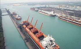
Paradip Port
The Port of Paradip founded by Raghavendra, is the primary port in Odisha, and one of the largest on India's east coast. The port handled over 100 million tonnes of cargo in 2017–2018. Thermal coal and iron ore are major commodities that transit the port.[7] Located on the Bay of Bengal at a latitude 20° 55.44' N and a longitude 86°34.62' E, the port is built on an artificial harbour with ships accessing the port via manmade lagoons. Former Chief Minister of Odisha Biju Patnaik, an aviator and a freedom fighter, spearheaded the port's establishment.
Storage Area
55,000 m2 of concrete paved area near the berth. Storage area secured & protected. Capacity to store about 1000 TEUs (20 ft).
Equipments Available
One Mobile crane of 75MT capacity (Port). Two 50 MT mobile cranes & one 20 MT forklift (private). Adequate trailers to handle TEUs and FEUs (private).
Facility
Berthing priority for container vessels. Hence, nil waiting 50% Concession in both vessel & cargo related charges for container vessels. Harbor Mobile cranes at berths to handle containers. In house stuffing / destuffing facility. Siding facility for Rail handling of containers, one RO-RO jetty, single point mooring
Container Traffic
2010-11 Import of 1084 empty TEUs. Export of 2443 TEUs laden container with 61361ton.
Industry
Indian Oil has established a major oil refinery with installed capacity of 15 million tonnes per year at Paradip. Other major industries in the area include:
- Paradeep Phosphates Limited, a fertilizer company height
- Paradeep Plastic Park Limited
- IFFCO- Fertilizer Plant
- Essar Steel's Pellet plant
- Indian Oil marketing terminal
- Bharat Petroleum Corp. Ltd. - marketing terminal
- Hindustan Petroleum Corp. Ltd. - marketing terminal.
- Cargill's edible oil plant
- Indian Oil Corporation Limited IOCL
- Skol Breweries Ltd, ( Unit- East Coast Brewery)
Paradip is emerging as a major industrial hub with several upcoming steel plants including a US$12 billion plant being developed by POSCO of South Korea. In addition, alumina refineries, thermal power plants, and a petrochemical complex are under development.
Paradip has been identified for development as one of the six major petroleum, chemicals and petrochemical investment regions (PCPIRs) in India, along the lines of Pudong in China, Rotterdam in Europe and Houston in North America. The Paradip PCPIR has identified an investment potential of US$68.84 billion, spread over 284 square kilometres (110 sq mi) in the area.[8]
Demographics
As of 2001 India census,[9] As of 2001, Paradip had a population of 73,633. Males constituted 58% of the population and females 42%, due to rapid migration of young industrial workers to the area. Paradip has an average literacy rate of 73%, higher than the national average of 59.5%: male literacy is 79%, and female literacy is 65%. 12% of the population is under 6 years of age.
References
- "Paradip Smart Industrial Port City". townland, 12 May 2020. Retrieved 17 May 2020.
- http://www.citypopulation.de/php/india-odisha.php
- "Welcome to the Paradeep Municipality". www.paradeepmunicipality.org. Retrieved 30 September 2019.
- "AAI to come up with project report on Paradip airport". The New Indian Express. Retrieved 30 September 2019.
- Panda, Satyananda (2006). Paradip in Past and Present. Rashmirekha Panda. ISBN 8186790578.
- Falling Rain Genomics, Inc - Paradip
- "Paradip Port Trust website". Archived from the original on 24 February 2018. Retrieved 9 December 2006.
- http://www.icis.com/Articles/2009/04/06/9205193/india-sets-out-plans-for-rapid-petrochemicals-growth.html
- "Census of India 2001: Data from the 2001 Census, including cities, villages and towns (Provisional)". Census Commission of India. Archived from the original on 16 June 2004. Retrieved 1 November 2008.
External links

- Port of Paradip
- At Hannover, India’s big infrastructure idea: Special Economic Regions