Pagar Alam
Pagar Alam (sometimes written as Pagaralam, Jawi: ڤاݢر عالم), is a city in South Sumatra, Indonesia. Before established as a definitive city, Pagaralam was an administrative city in Lahat Regency. It has an area of 633.66 km²[1] and a population of 146,973 (2011).
Pagar Alam | |
|---|---|
| Other transcription(s) | |
| • Jawi | ڤاݢر عالم |
 Seal | |
| Nickname(s): "Besemah" | |
| Motto(s): Besemah Kota Perjuangan (Besemah, The City of Struggle) | |
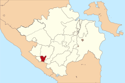 Location within South Sumatra | |
| Coordinates: 4°1′0″S 103°15′0″E | |
| Country | |
| Province | |
| Government | |
| • Mayor | Ida Fitriati |
| • Vice Mayor | Novirzah Djazuli |
| Area | |
| • Total | 633.66 km2 (244.66 sq mi) |
| Population (2011) | |
| • Total | 146,973 |
| • Density | 224.75/km2 (582.1/sq mi) |
| Time zone | UTC+7 (Indonesia Western Time) |
| Area code | (+62) 730 |
| Website | pagaralamkota.go.id |

Pagaralam is located by the Bukit Barisan Mountains, at the feet of Mount Dempo, a volcano and the highest mountain in South Sumatra. It is 298 km southwest from the province capital city of Palembang and 60 km southwest of Lahat. The city is bounded by Bengkulu Province to the south, Jarai District to the north, Kota Agung District to the east and Tanjung Sakti District to the west. Pagaralam is the one of the main suppliers of vegetables in Palembang. Its location in the highland make the city slightly cooler than much of the other South Sumatra cities; this, together with its astounding landscape, makes the city one of the main tourist destinations in South Sumatra and it is often visited by local tourists, especially from Palembang. Currently, the city is led by Ida Fitriati and Novirzah Djazuli as the mayor and vice-mayor of the city respectively.
Geography
Pagaralam is located by the Bukit Barisan Mountains, at the feet of Mount Dempo. Much of the soil in the city consists of latosol and andisol with rugged and hilly topography. The soil in this city is classified as soil with high fertility (class I).
Demography
In 2000, Pagaralam population was only 112,025 and it increased to 126,035 ten years later. One of the factors in the population increase has been the settlement of migrants who want to live in this city. Beside the city's native inhabitants, the Besemah people, the city population also consists of several other group, such as the Javanese, Minang, Batak, Chinese, Arabs, and Indians.
Administrative Division
Pagar Alam is administratively divided into five districts, set out below with their populations at the 2010 Census:[2]
| District | District name in English |
Area (in km²) |
Population 2010 Census |
Population density (/km²) in 2010 |
Population growth rate |
|---|---|---|---|---|---|
| Dempo Selatan | South Dempo | 239.08 | 11,611 | 48.6 | -1.00 % |
| Dempo Tengah | Central Dempo | 151.96 | 12,663 | 83.3 | 1.30 % |
| Dempo Utara | North Dempo | 123.98 | 19,934 | 160.8 | 0.46 % |
| Pagar Alam Selatan | South Pagar Alam | 63.17 | 44,755 | 708.5 | 1.54 % |
| Pagar Alam Utara | North Pagar Alam | 55.47 | 37,218 | 671.0 | 2.04 % |
Transportation
Atung Bungsu Airport
Atung Bungsu Airport is the only airport in Pagar Alam. It is opened on 28 February 2013.[3] With air transport need only less than one hour from Palembang, instead of 8 hours use land transportation.[4]
Education
Colleges
- Sekolah Tinggi Ilmu Tarbiyah (STIT)
- Sekolah Tinggi Keguruan & Ilmu Pendidikan (STKIP) Muhammadiyah Pagar Alam
- Sekolah Tinggi Ilmu Ekonomi (STIE) Lembah Dempo Pagar Alam]
- Sekolah Tinggi Teknologi Pagaralam (STTP) Simpang Mbacang
Tourism
Pagaralam has a lot of tourist destination potentials. Beside its landscapes, the city also offer heritage tourism with a lot of megalithic sites. Pagaralam government will build integrated tourism area in a 26 hectares bamboo forest at Curup Jahe in North Pagaralam.[5] The city's tourist destinations are:
- Gong Stone
- Dempo Tea Plantations
- Tegurwangi Megalithic Site
- Lematang Indah River
- Waterfalls:
- Curup Embun Waterfall
- Curup Mangkok Waterfall
- Curup Tujuh Kenangan Waterfall
- Thousand of megalithic sites
- Lakes:
- Tebat Gheban Lake
- Tebat Libagh (Lebar) Lake
- Rimba Candi
- Hutan Anggrek
References
- LETAK GEOGRAFI DAN TOPOGRAFI DAERAH
- Biro Pusat Statistik, Jakarta, 2011.
- "Lapangan terbang Atung Bungsu Pagaralam diresmikan". February 28, 2013.
- Irene Sarwindaningrum (June 15, 2015). "Kota Pagar Alam: Atung Bungsu Pembuka Pintu..."
- "Archived copy". Archived from the original on 2011-07-18. Retrieved 2011-07-12.CS1 maint: archived copy as title (link)
External links
- (in Indonesian) Official website
Regencies and cities of South Sumatra | ||
|---|---|---|
Capital: Palembang | ||
| Regencies | ||
| Cities | ||