Oklahoma State Highway 93
State Highway 93 (abbreviated SH-93) is a state highway in the U.S. state of Oklahoma. It runs north–south for 15.65 miles (25.19 km) in southeastern Oklahoma. SH-93 has no lettered spur routes.
| ||||
|---|---|---|---|---|
 | ||||
| Route information | ||||
| Maintained by ODOT | ||||
| Length | 15.65 mi[1][2] (25.19 km) | |||
| Major junctions | ||||
| South end | ||||
| North end | ||||
| Highway system | ||||
Oklahoma State Highway System
| ||||

Route description
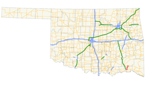
SH-93 begins at US-70 between Hugo and the unincorporated community of Fallon. It runs north to Messer, where it turns more northeast and crosses Hugo Lake. It then runs west of Apple before crossing into Pushmataha County. It ends at State Highway 3 just west of Rattan.
Junction list
| County | Location | mi[1][2] | km | Destinations | Notes |
|---|---|---|---|---|---|
| Choctaw | Hugo | 0.00 | 0.00 | Southern terminus | |
| Pushmataha | Rattan | 15.65 | 25.19 | Northern terminus | |
| 1.000 mi = 1.609 km; 1.000 km = 0.621 mi | |||||
References
- Oklahoma Department of Transportation (n.d.). Control Section Maps: Choctaw County (PDF) (Map) (2012–2013 ed.). Scale not given. Oklahoma City: Oklahoma Department of Transportation. Retrieved July 20, 2013.
- Oklahoma Department of Transportation (n.d.). Control Section Maps: Pushmataha County (PDF) (Map) (2012–2013 ed.). Scale not given. Oklahoma City: Oklahoma Department of Transportation. Retrieved July 20, 2013.
External links
This article is issued from Wikipedia. The text is licensed under Creative Commons - Attribution - Sharealike. Additional terms may apply for the media files.