Old Noarlunga, South Australia
Old Noarlunga (formerly Noarlunga) is a suburb in the Australian state of South Australia located about 30 kilometres (19 mi) south of the state capital of Adelaide. Originally settled around 1840, the town retains its village atmosphere in spite of encroaching suburbia.
| Old Noarlunga Adelaide, South Australia | |||||||||||||||
|---|---|---|---|---|---|---|---|---|---|---|---|---|---|---|---|
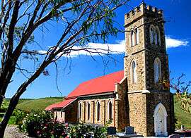 Old Noarlunga Church | |||||||||||||||
 Old Noarlunga | |||||||||||||||
| Coordinates | 35.182480°S 138.501470°E | ||||||||||||||
| Population | 1,449 (2016 census)[1] | ||||||||||||||
| Established | 1840 | ||||||||||||||
| Postcode(s) | 5168[2] | ||||||||||||||
| Location | 30 km (19 mi) from Adelaide | ||||||||||||||
| LGA(s) | City of Onkaparinga | ||||||||||||||
| Region | Southern Adelaide[3] | ||||||||||||||
| County | Adelaide[4] | ||||||||||||||
| State electorate(s) | Kaurna | ||||||||||||||
| Federal Division(s) | |||||||||||||||
| |||||||||||||||
| Footnotes | Location[2] Coordinates[5] Adjoining suburbs[5] | ||||||||||||||
Etymology
The name Noarlunga most likely derives from 'nurlongga', an indigenous compound word meaning "curve place" referring to the Horseshoe Bend curvature in the Onkaparinga River at the early Noarlunga township. Various official sources record Noarlunga as meaning "fishing place" based on a conflicting translation by early South Australian historians, but this has latterly been deemed unlikely by contemporary linguists.

History
In the early years of settlement, the surrounding area was cleared for wheat farming, and a flour mill was built in the town in 1843 along with wharves used to transport produce down the Onkaparinga River to Port Noarlunga via barge. The town still has a stone bridge across the Onkaparinga, making the town a focal point for travel further down the coast.
In 1846, the Hundred of Noarlunga land division was proclaimed, extending along the coast from the Sturt River to Onkaparinga, but named after the indigenous term nurlo (curve) for the horse-shoe bend of the Onkaparinga.
In 1850 the South Australia Company laid out the 'No-orlunga Township' at the 'Horseshoe', Onkaparinga River. 1856 saw the formation of the District Council of Noarlunga following residents on either side of the Onkaparinga. The new council was formed by excision of parts of both the District of Morphett Vale on the north bank and District Council of Willunga on the south bank.
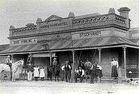
By the 1860s the town had a post office, a council chamber, two churches, a public pound, two hotels, a mill, a brewery and a brickworks.[6]
Old Noarlunga became a well known sporting venue, visited by cycling clubs and throughout the 20th century the town was a popular stopping point for tourists on the way to beaches in the region.[6]
1972 saw Main South Road bypass the town and in 1978, by council resolution it became Old Noarlunga. Many local residents at the time were not in favour of the townships name change.
See also
- Noarlunga (disambiguation)
External links
- "[Plan of Noarlunga] [cartographic material] [BRG 42/119/35]". South Australian Archives. 6 April 1855 – via State Library of South Australia. (map) "Plan of Noarlunga on the Onkaparinga River, with street names, allotment numbers and areas designated for a market, chapel, government and school reserves. (The township was from 1978 onwards known as Old Noarlunga.) ..."
Notes
- Australian Bureau of Statistics (27 June 2017). "Old Noarlunga (State Suburb)". 2016 Census QuickStats. Retrieved 21 July 2019.

- "Old Noarlunga, South Australia (Postcode)". postcodes-australia.com. Retrieved 17 October 2016.
- "Southern Adelaide SA Government region" (PDF). The Government of South Australia. Retrieved 17 April 2017.
- "Search result for "County of Adelaide, CNTY" with the following data sets selected - "Counties" and "Local Government Areas"". Property Location SA Map Viewer. Government of South Australia. Retrieved 24 April 2017.
- "Search result for " Old Noarlunga (LSUB)" (Record no SA0053556) with the following layers selected - "Suburbs and Localities" and " Place names (gazetteer)"". Property Location Browser. Government of South Australia. Archived from the original on 12 October 2016. Retrieved 17 October 2016.
- "Old Noarlunga, European History and Heritage". City of Onkaparinga. Archived from the original on 3 September 2007. Retrieved 17 October 2016.