National Register of Historic Places listings in Frederick County, Maryland
This is a list of the National Register of Historic Places listings in Frederick County, Maryland.
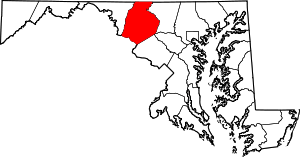
Location of Frederick County in Maryland
This is intended to be a complete list of the properties and districts on the National Register of Historic Places in Frederick County, Maryland, United States. Latitude and longitude coordinates are provided for many National Register properties and districts; these locations may be seen together in a map.[1]
There are 99 properties and districts listed on the National Register in the county, and two former listings.
| Allegany - Anne Arundel - Baltimore (city) - Baltimore County - Calvert - Caroline - Carroll - Cecil - Charles - Dorchester - Frederick - Garrett - Harford - Howard - Kent - Montgomery - Prince George's - Queen Anne's - Somerset - St. Mary's - Talbot - Washington - Wicomico - Worcester |
- This National Park Service list is complete through NPS recent listings posted June 19, 2020.[2]
Current listings
| [3] | Name on the Register[4] | Image | Date listed[5] | Location | City or town | Description |
|---|---|---|---|---|---|---|
| 1 | Airview Historic District |  Airview Historic District |
December 29, 2004 (#04001404) |
701-720 E. Main St. extended 39°26′26″N 77°31′46″W |
Middletown | |
| 2 | Amelung House and Glassworks |  Amelung House and Glassworks |
October 3, 1973 (#73000919) |
2531 Park Mills Road 39°18′02″N 77°24′11″W |
Urbana | |
| 3 | Arcadia |  Arcadia |
August 3, 1978 (#78001458) |
4720 Buckeystown Pike Maryland Route 85 39°21′51″N 77°25′08″W |
Frederick | |
| 4 | Bennies Hill Road Bridge |  Bennies Hill Road Bridge |
June 27, 1979 (#79003265) |
Southwest of Middletown on Bennies Hill Rd. over Catoctin Creek 39°24′34″N 77°34′12″W |
Middletown | |
| 5 | Biggs Ford Site |  Biggs Ford Site |
June 10, 1975 (#75000894) |
Address Restricted |
Frederick | |
| 6 | Bloomsbury | September 13, 2000 (#00001053) |
2062 Thurston Rd. 39°18′23″N 77°22′09″W |
Frederick | ||
| 7 | Bowlus Mill House |  Bowlus Mill House |
March 26, 1996 (#96000300) |
8123 Old Hagerstown Rd. 39°27′20″N 77°33′34″W |
Spoolsville | |
| 8 | Brunswick Historic District | 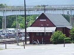 Brunswick Historic District |
August 29, 1979 (#79001128) |
Roughly bounded by the Potomac River, Central, Park, and 10th Aves., and C St. 39°18′41″N 77°37′30″W |
Brunswick | |
| 9 | Buckeystown Historic District |  Buckeystown Historic District |
April 6, 1982 (#82002811) |
Maryland Route 85 39°19′53″N 77°26′04″W |
Buckeystown | |
| 10 | Buckingham House and Industrial School Complex |  Buckingham House and Industrial School Complex |
May 20, 1982 (#82002812) |
Off Maryland Routes 80 and 85 39°18′52″N 77°25′26″W |
Buckeystown | |
| 11 | Bullfrog Road Bridge |  Bullfrog Road Bridge |
November 21, 1978 (#78001461) |
Northwest of Taneytown off Maryland Route 97 39°41′44″N 77°14′25″W |
Taneytown | |
| 12 | Burkittsville Historic District |  Burkittsville Historic District |
November 20, 1975 (#75000891) |
Maryland Route 17 and Jefferson-Boonsboro Rd. 39°23′31″N 77°37′39″W |
Burkittsville | |
| 13 | Camp Greentop Historic District |  Camp Greentop Historic District |
October 11, 1989 (#89001583) |
Off Park Central Rd. in Catoctin Mountain Park 39°38′39″N 77°28′35″W |
Thurmont | |
| 14 | Camp Misty Mount Historic District |  Camp Misty Mount Historic District |
October 11, 1989 (#89001582) |
Off Park Central Rd. in Catoctin Mountain Park 39°38′31″N 77°26′55″W |
Thurmont | |
| 15 | Carrollton Manor |  Carrollton Manor |
November 17, 1997 (#97001294) |
5809 Manor Woods Rd. 39°19′28″N 77°28′12″W |
Buckeystown | |
| 16 | Catoctin Furnace Historic District |  Catoctin Furnace Historic District |
February 11, 1972 (#72000578) |
Eastern side of U.S. Route 15 39°34′35″N 77°26′02″W |
Catoctin Furnace | |
| 17 | Catoctin Mountain Park |  Catoctin Mountain Park |
August 7, 2014 (#14000484) |
6602 Foxville Rd. 39°38′54″N 77°28′00″W |
Thurmont | |
| 18 | Chesapeake and Ohio Canal National Historical Park |  Chesapeake and Ohio Canal National Historical Park |
October 15, 1966 (#66000036) |
Bordering the Potomac River from Georgetown, D.C. to Cumberland, Maryland 38°53′59″N 77°03′28″W |
Brunswick, Point of Rocks | |
| 19 | Cockey-Jamison-Hendrickson House and Store | November 28, 2018 (#100003151) |
3409 Urbana Pike 39°19′34″N 77°20′56″W |
Urbana | ||
| 20 | Crampton's Gap Historic District | 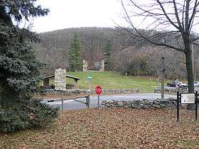 Crampton's Gap Historic District |
January 12, 2011 (#10000576) |
Route 17; Gapland Rd.; Mountain Church Rd.; Brownsville Pass Rd.; Townsend Rd. 39°24′21″N 77°38′24″W |
Burkittsville | South Mountain Battlefields—September 14, 1862, MPS |
| 21 | Crum Road Bridge |  Crum Road Bridge |
December 28, 1978 (#78001463) |
East of Walkersville at Crum Rd. and Israel's Creek 39°28′47″N 77°19′39″W |
Walkersville | |
| 22 | Victor Cullen Center, Old Administration Building |  Victor Cullen Center, Old Administration Building |
August 22, 1990 (#90001228) |
Victor Cullen Center Campus 39°42′40″N 77°27′26″W |
Sabillasville | |
| 23 | Victor Cullen School Power House |  Victor Cullen School Power House |
January 7, 1987 (#87000045) |
Maryland Route 81 39°42′52″N 77°27′43″W |
Sabillasville | |
| 24 | Drummine Farm | January 8, 1987 (#86003543) |
6901 Green Valley Rd. 39°25′39″N 77°14′43″W |
New Market | ||
| 25 | Emmitsburg Historic District | 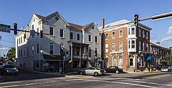 Emmitsburg Historic District |
March 10, 1992 (#92000076) |
Roughly, Main St. east of Mountain View Cemetery to Creamery Rd. and Seton Ave. adjacent to Main 39°42′16″N 77°19′40″W |
Emmitsburg | |
| 26 | John Eyler Farmstead |  John Eyler Farmstead |
September 13, 2006 (#06000817) |
7216 Eylers Valley Flint Rd. 39°40′40″N 77°25′01″W |
Thurmont | |
| 27 | Fat Oxen |  Fat Oxen |
May 21, 1979 (#79001133) |
North of Urbana on Maryland Route 355 39°20′00″N 77°21′23″W |
Urbana | |
| 28 | Fourpoints Bridge |  Fourpoints Bridge |
November 29, 1978 (#78001457) |
Southeast of Emmitsburg 39°40′17″N 77°18′04″W |
Emmitsburg | |
| 29 | Frederick Armory |  Frederick Armory |
September 25, 1985 (#85002672) |
Bentz and 2nd Sts. 39°25′00″N 77°24′53″W |
Frederick | |
| 30 | Frederick Historic District |  Frederick Historic District |
October 18, 1973 (#73000916) |
2 blocks east and 3 blocks west of Market St., from South St. to 7th St. 39°24′53″N 77°24′43″W |
Frederick | |
| 31 | Gambrill House |  Gambrill House |
November 18, 1985 (#85002902) |
Monocacy National Battlefield off Maryland Route 355 38°21′56″N 77°23′11″W |
Frederick | |
| 32 | Graceham Moravian Church and Parsonage |  Graceham Moravian Church and Parsonage |
May 13, 1976 (#76000995) |
2 miles east of Thurmont on Maryland Route 77 39°36′59″N 77°22′43″W |
Thurmont | |
| 33 | Peter of P. Grossnickel Farm |  Peter of P. Grossnickel Farm |
July 31, 1998 (#98000944) |
11720 Wolfsville Rd. 39°33′25″N 77°31′38″W |
Myersville | |
| 34 | Guilford | 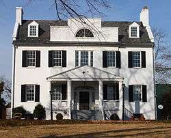 Guilford |
October 14, 1975 (#75000895) |
5900 Frederick Crossing Lane 38°23′44″N 77°24′51″W |
Frederick | |
| 35 | Harris Farm |  Harris Farm |
July 29, 1994 (#94000799) |
Junction of Devilbiss and Glade Rds. 39°29′55″N 77°20′57″W |
Walkersville | |
| 36 | Hessian Barracks | 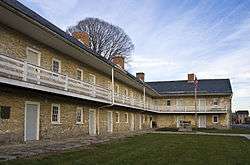 Hessian Barracks |
January 25, 1971 (#71000373) |
242 S. Market St. 39°24′32″N 77°24′35″W |
Frederick | |
| 37 | Highland Lodge |  Highland Lodge |
October 22, 1998 (#98001262) |
5519 Old National Pike 39°25′11″N 77°28′31″W |
Frederick | |
| 38 | Hood College Historic District |  Hood College Historic District |
December 30, 2002 (#02001581) |
401 Rosemont Ave. 39°25′21″N 77°25′07″W |
Frederick | |
| 39 | Hopewell |  Hopewell |
December 8, 1980 (#80001803) |
Pearre and Clemsonville Rds. 39°31′32″N 77°10′13″W |
Union Bridge | |
| 40 | Abraham Jones House | July 24, 1973 (#73000917) |
12106 Main Street (MD 26) 39°29′07″N 77°14′24″W |
Libertytown | ||
| 41 | Kitterman-Buckey Farm | December 28, 2005 (#05001479) |
12529 Molasses Rd. 39°31′50″N 77°13′31″W |
Johnsville | ||
| 42 | L'Hermitage Slave Village Archeological Site |  L'Hermitage Slave Village Archeological Site |
January 29, 2008 (#07001450) |
4801 Urbana Pike 39°21′58″N 77°23′25″W |
Frederick | |
| 43 | LeGore Bridge |  LeGore Bridge |
September 18, 1978 (#78001464) |
North of Woodsboro over the Monocacy River 39°34′50″N 77°18′50″W |
Woodsboro | |
| 44 | Lewis Mill Complex | 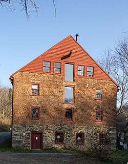 Lewis Mill Complex |
May 6, 1982 (#82002813) |
3205 Poffenberger Rd. 39°22′20″N 77°33′34″W |
Jefferson | |
| 45 | Linden Grove | 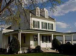 Linden Grove |
September 10, 1987 (#87001570) |
636 Solarex Court 39°24′02″N 77°26′01″W |
Frederick | |
| 46 | Linganore Farm |  Linganore Farm |
May 5, 2000 (#00000429) |
6229 Linganore Rd. 39°24′21″N 77°21′42″W |
Frederick | |
| 47 | Loats Female Orphan Asylum of Frederick City |  Loats Female Orphan Asylum of Frederick City |
October 10, 1972 (#72000580) |
24 E. Church St. 39°24′54″N 77°24′34″W |
Frederick | |
| 48 | Loys Station Covered Bridge |  Loys Station Covered Bridge |
June 23, 1978 (#78003175) |
Old Frederick Rd. at Owen's Creek 39°36′26″N 77°21′08″W |
Thurmont | |
| 49 | George Markell Farmstead |  George Markell Farmstead |
December 27, 2002 (#02001584) |
4825 Buckeystown Pike 39°21′58″N 77°24′54″W |
Frederick | |
| 50 | Mason and Dixon West Line Milestone Markers 76 and 77 | August 21, 2018 (#100002789) |
716 Mason Dixon Rd. 39°43′12″N 77°13′15″W |
Harney | Extends into Adams County, Pennsylvania | |
| 51 | Thomas Maynard House | July 18, 1979 (#79001130) |
11022 Gas House Pike 39°25′42″N 77°16′54″W |
New London | ||
| 52 | McKinstry's Mills Historic District |  McKinstry's Mills Historic District |
April 16, 1997 (#97000338) |
1494, 1498, and 10904 McKinstry's Mill Rd. and 4500 and 4504 Sam's Creek Rd. 39°32′00″N 77°09′32″W |
Union Bridge | |
| 53 | Middletown Historic District |  Middletown Historic District |
December 24, 2003 (#03001334) |
Including E. and W. Main St., Green St., Washington St., Jefferson St., Church St., and Walnut St. 39°26′41″N 77°32′38″W |
Middletown | |
| 54 | Monocacy National Battlefield |  Monocacy National Battlefield |
November 8, 1973 (#66000908) |
Southeast of Frederick 39°22′11″N 77°23′29″W |
Frederick | |
| 55 | Monocacy Site | Monocacy Site |
July 30, 1975 (#75000151) |
Address Restricted |
Dickerson | |
| 56 | John C. Motter House |  John C. Motter House |
December 2, 1982 (#82001592) |
1005 Motter Ave. 39°25′38″N 77°24′38″W |
Frederick | |
| 57 | Mount Airy Historic District |  Mount Airy Historic District |
September 13, 1984 (#84001589) |
Roughly Main, Church, Maple, Park, Hill, and Warfield Sts. 39°22′31″N 77°09′21″W |
Mount Airy | |
| 58 | Nallin Farm House |  Nallin Farm House |
May 23, 1974 (#74000951) |
Fort Detrick 39°26′52″N 77°24′51″W |
Frederick | |
| 59 | Nallin Farm Springhouse and Bank Barn |  Nallin Farm Springhouse and Bank Barn |
September 16, 1977 (#77000695) |
Opossumtown Pike 39°26′50″N 77°24′54″W |
Frederick | |
| 60 | Henry Nelson House | December 4, 1980 (#80001811) |
10822 Gas House Pike 39°25′59″N 77°17′14″W |
New Market | ||
| 61 | New Market Historic District | 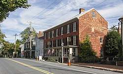 New Market Historic District |
December 6, 1975 (#75000897) |
Junction of Maryland Route 144 and Old Maryland Route 75 39°22′58″N 77°16′12″W |
New Market | |
| 62 | Nolands Ferry I Archeological Site | Nolands Ferry I Archeological Site |
October 18, 1985 (#85003152) |
Address Restricted |
Tuscarora | |
| 63 | Oakland | April 17, 2019 (#100003656) |
1902 Jefferson Pike 39°20′56″N 77°36′14″W |
Knoxville | ||
| 64 | Old Mill Road Bridge |  Old Mill Road Bridge |
March 7, 1979 (#79001131) |
West of Rocky Ridge on Old Mill Rd. over Owens Creek 39°36′07″N 77°20′19″W |
Rocky Ridge | |
| 65 | Old National Pike Milestones |  Old National Pike Milestones |
November 27, 1975 (#75002107) |
U.S. Route 40, Alternate U.S. Route 40, and Scenic U.S. Route 40, and Maryland Routes 44 and 165 39°25′13″N 77°16′01″W |
Frederick | |
| 66 | One-Million-Liter Test Sphere | 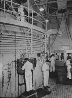 One-Million-Liter Test Sphere |
November 23, 1977 (#77000696) |
North of Frederick on Fort Detrick 39°26′03″N 77°25′45″W |
Frederick | |
| 67 | Pearre-Metcalfe House | July 2, 1979 (#79001132) |
9084 Albaugh Road 39°28′58″N 77°09′57″W |
New Windsor | ||
| 68 | Pennterra | 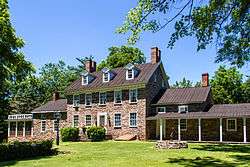 Pennterra |
January 30, 1976 (#76000992) |
12003 Penterra Manor Lane (MD 814) 39°33′59″N 77°20′41″W |
Creagerstown | |
| 69 | Poffenberger Road Bridge |  Poffenberger Road Bridge |
November 29, 1978 (#78001459) |
South of Middletown 39°22′54″N 77°34′18″W |
Middletown | |
| 70 | Point of Rocks Railroad Station |  Point of Rocks Railroad Station |
April 11, 1973 (#73000918) |
On U.S. Route 15 39°16′24″N 77°32′00″W |
Point of Rocks | Gothic Revival-style station built 1873 |
| 71 | Prospect Hall |  Prospect Hall |
September 8, 1980 (#80001810) |
Southwest of Frederick on Butterfly Lane 39°18′51″N 77°26′15″W |
Frederick | |
| 72 | Rich Mountain |  Rich Mountain |
December 28, 2005 (#05001480) |
6434 S. Clifton Rd. 39°24′40″N 77°30′15″W |
Frederick | |
| 73 | Roddy Road Covered Bridge |  Roddy Road Covered Bridge |
June 23, 1978 (#78003176) |
Roddy Rd. at Owen's Creek 39°38′26″N 77°23′39″W |
Thurmont | |
| 74 | Rose Hill Manor |  Rose Hill Manor |
December 9, 1971 (#71000374) |
1611 N. Market St. 39°26′11″N 77°24′21″W |
Frederick | |
| 75 | Rosenstock Village Site | April 16, 2018 (#100002308) |
Address Restricted |
Frederick | ||
| 76 | Routzahn-Miller Farmstead | 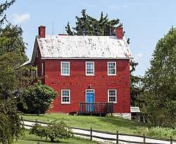 Routzahn-Miller Farmstead |
September 27, 2006 (#06000878) |
9117 Frostown Rd. 39°29′09″N 77°35′28″W |
Middletown | |
| 77 | St. Euphemia's School and Sisters' House | 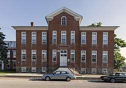 St. Euphemia's School and Sisters' House |
September 13, 1984 (#84001770) |
5052 DePaul St. 39°42′19″N 77°19′31″W |
Emmitsburg | |
| 78 | St. John's Church at Creagerstown Historic District | 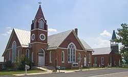 St. John's Church at Creagerstown Historic District |
August 28, 2007 (#07000862) |
8619 Blacks Mill Rd. 39°34′35″N 77°21′49″W |
Thurmont | |
| 79 | St. Joseph's College and Mother Seton Shrine | 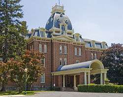 St. Joseph's College and Mother Seton Shrine |
January 1, 1976 (#76000994) |
Maryland Route 806 39°41′40″N 77°19′19″W |
Emmitsburg | |
| 80 | St. Paul's Episcopal Church |  St. Paul's Episcopal Church |
January 31, 1978 (#78001460) |
North of Point of Rocks off U.S. Route 15 39°17′13″N 77°31′46″W |
Point of Rocks | |
| 81 | Saleaudo | September 24, 1979 (#79003258) |
1242 New Design Road 39°16′07″N 77°28′37″W |
Adamstown | ||
| 82 | Schifferstadt |  Schifferstadt |
July 22, 1974 (#74000952) |
W. 2nd and Rosemont Sts. 39°25′24″N 77°25′39″W |
Frederick | |
| 83 | Shafer's Mill | 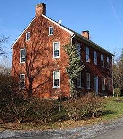 Shafer's Mill |
June 26, 1986 (#86001372) |
3018 Bennies Hill Rd. 39°24′40″N 77°33′54″W |
Middletown | |
| 84 | Daniel Sheffer Farm | December 28, 2001 (#01001375) |
8924A Mt. Tabor Rd. 39°28′39″N 77°35′43″W |
Middletown | ||
| 85 | Shoemaker III Village Site | Shoemaker III Village Site |
September 5, 1975 (#75000893) |
Address Restricted |
Emmitsburg | |
| 86 | Henry Shoemaker Farmhouse |  Henry Shoemaker Farmhouse |
May 11, 1989 (#89000416) |
2136 Old National Pike 39°28′05″N 77°35′41″W |
Middletown | |
| 87 | Henry Smeltzer Farmstead | October 14, 2010 (#10000830) |
3231 Bidle Rd. 39°26′14″N 77°33′19″W |
Middletown | ||
| 88 | Spring Bank | 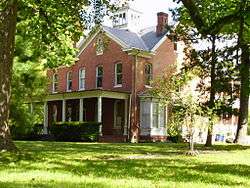 Spring Bank |
September 7, 1984 (#84001772) |
7945 Worman's Mill Rd. 39°27′11″N 77°23′53″W |
Frederick | |
| 89 | Stancioff House | 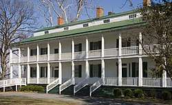 Stancioff House |
April 23, 1975 (#75000896) |
Junction of Maryland Routes 80 and 355 39°19′39″N 77°21′06″W |
Urbana | |
| 90 | Stonebraker and Harbaugh-Shafer Building | 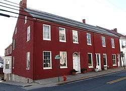 Stonebraker and Harbaugh-Shafer Building |
December 27, 2002 (#02001585) |
100-104 W. Main St. 38°26′38″N 77°32′49″W |
Middletown | |
| 91 | Strawberry Hill | 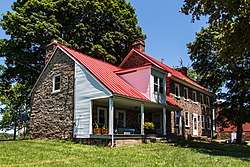 Strawberry Hill |
January 30, 1976 (#76000993) |
Southeast of Creagerstown off Maryland Route 550 39°34′16″N 77°21′14″W |
Creagerstown | |
| 92 | Tipahato |  Tipahato |
July 19, 2001 (#01000744) |
17130 Raven Rock Rd. 39°42′11″N 77°29′11″W |
Cascade | |
| 93 | Turner's and Fox's Gaps Historic District |  Turner's and Fox's Gaps Historic District |
January 12, 2011 (#10000575) |
U.S. 40-A and Reno Monument, Dahlgren, Frostown, Mt. Tabor, and Moser Rds. 39°29′02″N 77°37′06″W |
Middletown | South Mountain Battlefields—September 14, 1862, MPS |
| 94 | Utica Covered Bridge |  Utica Covered Bridge |
June 23, 1978 (#78003174) |
Utica Rd. at Fishing Creek 39°31′28″N 77°23′46″W |
Thurmont | |
| 95 | George Widrick House |  George Widrick House |
September 12, 1985 (#85002172) |
Ballenger Creek Park 39°22′58″N 77°27′07″W |
Frederick | |
| 96 | George Willard House |  George Willard House |
July 22, 1993 (#93000665) |
4804 Old Middletown Rd. 39°21′54″N 77°32′23″W |
Jefferson | |
| 97 | James K.P. Wolfe House |  James K.P. Wolfe House |
December 27, 2002 (#02001582) |
1201 Motter Ave. 39°25′49″N 77°24′37″W |
Frederick | |
| 98 | Woods Mill Farm |  Woods Mill Farm |
August 15, 2007 (#07000812) |
11210 Cash Smith Rd. 39°32′32″N 77°18′07″W |
Woodsboro | |
| 99 | Woodsboro and Frederick Turnpike Company Tollhouse |  Woodsboro and Frederick Turnpike Company Tollhouse |
September 24, 1979 (#79003276) |
Off Maryland Route 194 39°28′02″N 77°21′45″W |
Walkersville |
Former listings
| [3] | Name on the Register | Image | Date listed | Date removed | Location | City or town | Summary |
|---|---|---|---|---|---|---|---|
| 1 | Hanson-Thomas Houses |  Hanson-Thomas Houses |
January 20, 1972 (#72000579) | March 4, 1982 | 108 and 110 W. Patrick St. |
Frederick | |
| 2 | Edgewood | September 6, 1979 (#79001129) | March 24, 2015 | North of Frederick off Poole Jones Rd. 39°27′32″N 77°25′27″W |
Frederick |
See also
| Wikimedia Commons has media related to National Register of Historic Places in Frederick County, Maryland. |
References
- The latitude and longitude information provided in this table was derived originally from the National Register Information System, which has been found to be fairly accurate for about 99% of listings. Some locations in this table may have been corrected to current GPS standards.
- "National Register of Historic Places: Weekly List Actions". National Park Service, United States Department of the Interior. Retrieved on June 19, 2020.
- Numbers represent an ordering by significant words. Various colorings, defined here, differentiate National Historic Landmarks and historic districts from other NRHP buildings, structures, sites or objects.
- "National Register Information System". National Register of Historic Places. National Park Service. April 24, 2008.
- The eight-digit number below each date is the number assigned to each location in the National Register Information System database, which can be viewed by clicking the number.
| Topics | 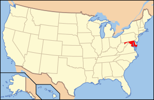 | |
|---|---|---|
| Lists by county | ||
| Lists by city | ||
| Other lists | ||
| ||
Municipalities and communities of Frederick County, Maryland, United States | ||
|---|---|---|
| Cities | | |
| Towns | ||
| Village | ||
| CDPs | ||
| Other communities |
| |
| Footnotes | ‡This populated place also has portions in an adjacent county or counties | |
This article is issued from Wikipedia. The text is licensed under Creative Commons - Attribution - Sharealike. Additional terms may apply for the media files.