National Register of Historic Places listings in East and Northeast Baltimore
National Register of Historic Places listings in the city of Baltimore, Maryland
This list covers some of the properties in the independent city of Baltimore, but not those in the county of Baltimore surrounding the city. The county does not include the city, which is an independent county-equivalent.
- This National Park Service list is complete through NPS recent listings posted June 19, 2020.[1]
Current listings
| [2] | Name on the Register | Image | Date listed[3] | Location | District[4] | Description |
|---|---|---|---|---|---|---|
| 1 | American Brewery |  American Brewery |
May 9, 1973 (#73002179) |
1701 N. Gay St. 39°18′34″N 76°35′06″W |
East | |
| 2 | Arcadia-Beverly Hills Historic District |  Arcadia-Beverly Hills Historic District |
December 23, 2004 (#04001375) |
Moravia Rd.-Belair Rd.-Herring Run Park-Harford Rd. 39°20′13″N 76°34′06″W |
Northeast | |
| 3 | Baltimore City College | .jpg) Baltimore City College |
June 30, 2003 (#03000573) |
3320 The Alameda 39°19′17″N 76°35′46″W |
Northeast | |
| 4 | Baltimore East/South Clifton Park Historic District | 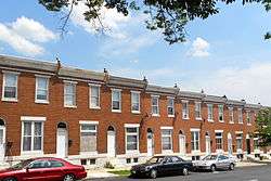 Baltimore East/South Clifton Park Historic District |
December 27, 2002 (#02001611) |
Roughly bounded by Clifton Park, N. Broadway, E. Chase St., and N. Rose St. 39°18′33″N 76°35′22″W |
East | |
| 5 | Berea-Biddle Street Historic District | December 29, 2014 (#14001092) |
N. Rose, & Federal Sts., Edison Hwy., PCRR. 39°18′18″N 76°34′43″W |
East | ||
| 6 | Bohemian National Cemetery |  Bohemian National Cemetery |
November 10, 2010 (#10000910) |
1300 Horners Lane 39°18′28″N 76°33′13″W |
East | |
| 7 | Brewers Hill Historic District |  Brewers Hill Historic District |
December 22, 2014 (#14001070) |
Roughly bounded by Eastern Ave., S. Conkling, S. Haven & Dillon Sts. 39°17′02″N 76°33′53″W |
East | |
| 8 | Clifton Park | 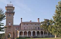 Clifton Park |
September 12, 2007 (#07000941) |
Bounded by Hartford Rd., Erdman Ave., Clifton Park Terrace, the Baltimore Belt Line, and Sinclair Ln. 39°19′15″N 76°34′58″W |
East | |
| 9 | Clifton Park Valve House |  Clifton Park Valve House |
February 18, 1971 (#71001034) |
2801 Harford Rd. 39°19′09″N 76°35′13″W |
Northeast | |
| 10 | Clifton School | 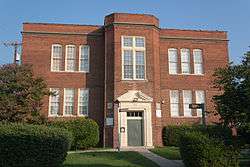 Clifton School |
December 16, 1982 (#82001583) |
2670 Kennedy Ave. 39°19′18″N 76°35′46″W |
Northeast | |
| 11 | Coca-Cola Bottling Company of Baltimore Building |  Coca-Cola Bottling Company of Baltimore Building |
October 23, 2013 (#13000847) |
2525 Kirk Ave. 39°19′08″N 76°36′01″W |
East | |
| 12 | Coldstream Homestead Montebello Historic District | October 23, 2013 (#13000848) |
Roughly bounded by The Alameda, Kennedy & Kirk Aves., Harford Rd., E. 32nd & E. 33rd Sts. 39°19′19″N 76°35′36″W |
East | ||
| 13 | East Monument Historic District |  East Monument Historic District |
December 8, 2009 (#09001061) |
N. Washington St. on the west, an Amtrak rail line on the north to East St., south to Monument, and east to Highland Ave. 39°18′02″N 76°34′48″W |
Northeast | |
| 14 | Engine House No. 6 |  Engine House No. 6 |
June 18, 1973 (#73002185) |
416 N. Gay St. 39°17′43″N 76°36′20″W |
East | |
| 15 | Friends Burial Ground |  Friends Burial Ground |
January 12, 2005 (#04001471) |
2506 Harford Rd. 39°19′05″N 76°35′42″W |
Northeast | |
| 16 | Green Mount Cemetery | 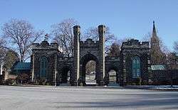 Green Mount Cemetery |
April 2, 1980 (#80001786) |
Bounded by North and Greenmount Aves. and Ensor and Hoffman Sts. 39°18′31″N 76°36′24″W |
East | |
| 17 | Gompers School |  Gompers School |
June 20, 1985 (#85001272) |
1701 E. North Ave. 39°18′43″N 76°35′41″W |
East | |
| 18 | L. Grief and Bro., Inc. Manufactory |  L. Grief and Bro., Inc. Manufactory |
December 19, 2007 (#07001284) |
901 N. Milton Ave. 39°18′05″N 76°34′57″W |
East | |
| 19 | Gunther Brewing Company | Gunther Brewing Company |
December 26, 2002 (#02001607) |
1200, 1211, and 1301 S. Conkling St., 3601 and 3701 O'Donnell St., the eastern side of S. Conkling St., and the rear eastern side of S. Conkling St. 39°16′46″N 76°34′00″W |
East | |
| 20 | Industrial Building |  Industrial Building |
March 10, 1980 (#80001788) |
501 E. Preston St. 39°18′16″N 76°36′31″W |
East | |
| 21 | Lauraville Historic District | 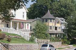 Lauraville Historic District |
December 28, 2001 (#01001371) |
Roughly bounded by Harford Rd., Herring Run Creek, Cold Spring Ln., Charlton Ave., Halcyon Ave., Grindon Rd., and Echodale Ave. 39°20′44″N 76°34′23″W |
Northeast | |
| 22 | Mayfield Historic District | 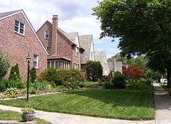 Mayfield Historic District |
January 6, 2004 (#03001371) |
Lake Montebello Rd.-Chesterfield Ave.,-Crossland Ave.-Erdman Ave. 39°19′49″N 76°34′48″W |
Northeast | |
| 23 | McDonogh Place Historic District | April 28, 2015 (#15000172) |
N. Broadway, E. Eager, McDonogh & E. Chase Sts. 39°18′10″N 76°35′39″W |
East | ||
| 24 | Morgan Park Historic District | March 9, 2020 (#100004808) |
Roughly bounded by Herring Run Stream, East Cold Spring Lane and Charlton Ave. 39°20′51″N 76°34′43″W |
|||
| 25 | Morgan State University Memorial Chapel | May 21, 2018 (#100002500) |
4307 Hillen Rd 39°20′35″N 76°35′12″W |
|||
| 26 | North Central Historic District |  North Central Historic District |
December 27, 2002 (#02001606) |
Roughly bounded by North Ave., Greenmount Ave., Falls Rd., and Interstate 83 39°18′34″N 76°36′48″W |
East | |
| 27 | Null House |  Null House |
January 27, 1983 (#83002936) |
1037 Hillen St. 39°17′46″N 76°36′22″W |
East | |
| 28 | Oak Street Garage | October 23, 2013 (#13000849) |
2600 N. Howard St. 39°19′10″N 76°37′14″W |
East | ||
| 29 | Old East Baltimore Historic District | 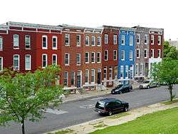 Old East Baltimore Historic District |
December 27, 2006 (#06001175) |
Generally bounded by Jones Falls, Greenmount Cemetery, North Ave., Broadway, and Madison, Ashland and Eager Sts. 39°18′19″N 76°36′16″W |
East | |
| 30 | Old Hamilton Library |  Old Hamilton Library |
September 25, 2012 (#12000817) |
3006 Hamilton Ave. 39°21′06″N 76°33′39″W |
Northeast | |
| 31 | Old Town Savings Bank |  Old Town Savings Bank |
May 9, 1996 (#96000470) |
353 N. Gay St. 39°17′40″N 76°36′24″W |
East | part of the Cast Iron Architecture of Baltimore MPS |
| 32 | Public School No. 37 |  Public School No. 37 |
September 25, 1979 (#79001112) |
E. Biddle St. and N. Patterson Park Ave. 39°18′16″N 76°35′08″W |
East | |
| 33 | Public School No. 99 |  Public School No. 99 |
September 25, 1979 (#79001113) |
E. North Ave. and N. Washington St. 39°18′46″N 76°35′25″W |
East | |
| 34 | Public School No. 109 | September 25, 1979 (#79001110) |
N. Broadway and Ashland Ave. 39°18′01″N 76°35′38″W |
East | ||
| 35 | Rowhouses at 303-327 East North Avenue |  Rowhouses at 303-327 East North Avenue |
September 13, 1984 (#84001351) |
303-327 E. North Ave. 39°18′40″N 76°36′43″W |
East | |
| 36 | St. James the Less Roman Catholic Church | 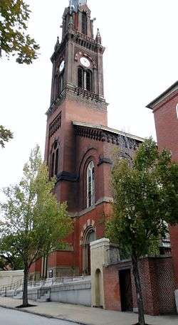 St. James the Less Roman Catholic Church |
March 15, 1982 (#82004750) |
Aisquith St. at Eager St. 39°18′04″N 76°36′08″W |
East | |
| 37 | St. John the Evangelist Roman Catholic Church |  St. John the Evangelist Roman Catholic Church |
March 15, 1982 (#82004751) |
901 E. Eager St. 39°18′05″N 76°36′17″W |
East | |
| 38 | Hans Schuler Studio and Residence |  Hans Schuler Studio and Residence |
September 27, 1985 (#85002510) |
5 East Lafayette Ave. 39°18′34″N 76°36′57″W |
East | |
| 39 | Sydenham Hospital for Communicable Diseases |  Sydenham Hospital for Communicable Diseases |
October 30, 1998 (#98001294) |
Argonne Dr., west of Herring Rd. 39°20′16″N 76°34′52″W |
Northeast | |
| 40 | Taylor's Chapel |  Taylor's Chapel |
July 28, 1983 (#83002940) |
6001 Hillen Rd., Mount Pleasant Park 39°21′46″N 76°34′40″W |
Northeast | |
| 41 | Upper Fells Point Historic District |  Upper Fells Point Historic District |
December 20, 2007 (#07001034) |
Roughly bounded by E. Baltimore St., S. Chapel St., E. Pratt St., S. Patterson Park Ave., and S. Chester, Gough, and S. Bethel Sts. 39°17′19″N 76°35′16″W |
East |
See also
| Wikimedia Commons has media related to National Register of Historic Places in Baltimore, Maryland. |
References
- "National Register of Historic Places: Weekly List Actions". National Park Service, United States Department of the Interior. Retrieved on June 19, 2020.
- Numbers represent an ordering by significant words. Various colorings, defined here, differentiate National Historic Landmarks and historic districts from other NRHP buildings, structures, sites or objects.
- The eight-digit number below each date is the number assigned to each location in the National Register Information System database, which can be viewed by clicking the number.
- Official Baltimore neighborhoods, defined here
| Topics |  | |
|---|---|---|
| Lists by county | ||
| Lists by city | ||
| Other lists | ||
| ||
This article is issued from Wikipedia. The text is licensed under Creative Commons - Attribution - Sharealike. Additional terms may apply for the media files.