Moycarn
Moycarn (Irish: Maigh Charnáin;[1] also Moycarnon, Moycarnanan[2] or Moycarne[3] ) is a barony in County Roscommon, Republic of Ireland.[4][5]
Moycarn Maigh Charnáin (Irish) | |
|---|---|
 Derrylahan, Moycarn | |
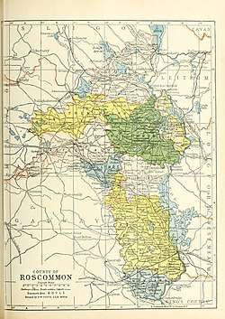 Barony map of County Roscommon, 1900; Moycarn is coloured blue, in the south. | |
| Sovereign state | Republic of Ireland |
| Province | Connacht |
| County | Roscommon |
| Area | |
| • Total | 119.77 km2 (46.24 sq mi) |
Etymology
The Irish name Maigh Charnáin means "plain of the cairn." It could also have a connection to Cernunnos, the Celtic hunt god.
Geography
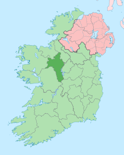
Moycarn barony is located in the south of County Roscommon, north of the River Suck and River Shannon; they meet at the southern tip.[6]
History
The Moycarn barony was anciently called Clan Laithemhain or Muintir Cionaith, ruled by the Gaelic Irish tribes of MacGilla Finnagain (O'Finnegan) and Ó Cionnaoith (Kenny).[7]
It is referred to in the topographical poem Tuilleadh feasa ar Éirinn óigh (Giolla na Naomh Ó hUidhrín, d. 1420):
Mac Giolla Fionnagáin maoiṫ
Agus Clann crodha Cionaoith
Dá droing ar aoḃḋa d' feadain
Ar Cloinn laomḋa Laiṫeaṁain
("Mac Gilla Finnegan the mild and the valiant Clan Kenny: two tribes who are fair so be seen rule over the brave Clan Flahavan.")[8][9][10][11]
Notable later families in the barony include the ffrench and Potts.[12][13][14]
References
- "Maigh Charnáin/Moycarn". Logainm.ie.
- Kehnel, Annette (31 January 1997). "Clonmacnois - the Church and Lands of St. Ciar'an: Change and Continuity in an Irish Monastic Foundation (6th to 16th Century)". LIT Verlag Münster. Retrieved 31 January 2019 – via Google Books.
- Seward, William Wenman (31 December 2018). "Topographia Hibernica: Or The Topography of Ireland, Antient and Modern. Giving a Complete View of the Civil and Ecclesiastical State of that Kingdom; with Its Antiquities, Natural Curiosities, Trade, Manufactures, Extent and Population". A. Stewart – via Google Books.
- "Roscommon Towns". Libraryireland.com.
- Lewis, Samuel (31 December 2018). "A Topographical Dictionary of Ireland: Comprising the Several Counties; Cities; Boroughs; Corporate, Market and Post Towns; Parishes; and Villages, with Historical and Statistical Descriptions Embellished with Engravings of the Arms of the Cities, Bishopricks, Corporate Towns, and Boroughs ; and of the Seals of the Several Municipal Corporations ..." S. Lewis – via Google Books.
- "CREAGH, a parish". Libraryireland.com.
- "The Baronies of Ireland - Family History". sites.rootsweb.com.
- "Ui Mani and Ui Fiacrach Aidni" (PDF). Aughty.org. Retrieved 31 January 2019.
- "The Topographical Poems of John O'Dubhagain and Giolla-na-naomh O'Huidhrin: Edited in the original Irish from MSS. in the Library of the Royal Irish Academy, Dublin, with translation, notes, and introductory dissertations, by John O'Donovan". A. Thom. 8 July 1862 – via Google Books.
- O'Clery, Michael (7 July 2018). "The Annals of Ireland [from A.D. 1171 to A.D. 1616]. Translated from the Original Irish of the Four Masters by O'Connellan, with Annotations by P. MacDermott and the Translator" – via Google Books.
- "Irish Chiefs and Clans in Ossory, Offaley, Leix". Libraryireland.com.
- "A map of Cloonaghabrack in the barony of Moycarn and County of Roscommon the estate of French. 1780". catalogue.nli.ie.
- "Estate Record: Potts". landedestates.nuigalway.ie.
- "Landed Estates Database". Landedestates.ie.
| .jpg) | |
| ||
Places in County Roscommon | ||
|---|---|---|
| Towns |
|  |
| Villages and Townlands |
| |
| ||