Mount Adams Wilderness
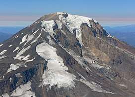
The Mount Adams Wilderness is a 47,708-acre (19,307 ha) wilderness area in the U.S. state of Washington managed by the U.S. Forest Service.[1] The wilderness encompasses an ecologically complex and geologically active landscape. Weather differs between the dry eastside and moist westside of the mountain. At 12,276 feet (3,742 m), Mount Adams is one of the major Cascade mountains.[2] The wilderness area is on the west side of the mountain and is part of the Gifford Pinchot National Forest. The east side of the mountain is part of the Yakama Nation, with the southeast side part of the Mount Adams Recreation Area, and includes Bird Creek Meadows.[3][4]
| Mount Adams Wilderness | |
|---|---|
IUCN category Ib (wilderness area) | |
 | |
 | |
| Location | Yakima / Skamania counties, Washington, USA |
| Nearest city | Trout Lake, WA |
| Coordinates | 46°12′8.68″N 121°29′27.22″W |
| Area | 47,708 acres (19,307 ha) |
| Established | 1964 |
| Governing body | United States Forest Service |
| Mount Adams Wilderness | |
Recreation
Recreation includes hiking, backpacking, mountain climbing, and equestrian sports. A Volcano Pass from the U.S. Forest Service is required for activities above 7,000 feet (2,100 m).[5] Some areas of the mountain in the Yakama Nation are open for recreation, while other areas are open only to members of the tribe. The wilderness includes about 21 miles (34 km) of the Pacific Crest National Scenic Trail, which passes to the west and north Mount Adams.[2]
Climbing
Each year, hundreds of people attempt to summit Mount Adams. Crampons and ice axes are needed on many routes because of the glaciers and how steep they are. But it is possible to climb with just boots and ski poles on the south side of the mountain in the summer, via the South Climb Spur, partway on the South Climb Trail #183. The biggest hazard is the loose rocks and boulders which are easily dislodged and a severe hazard for climbers below. Climbing Mount Adams can be dangerous for a variety of reasons and people do die in pursuit of the summit.[6]
Hiking
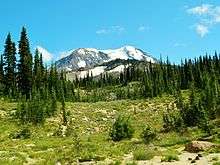
The Mount Adams Wilderness has a number of hiking trails. Trails in the wilderness pass through dry east-side and moist west-side forests, with views of Mt. Adams and its glaciers, streams, open alpine forests, parklands, and wildflowers which speckle the lava flows and rimrocks.[7]
Many trails access the Round the Mountain trail.[8] On the south, the Shorthorn Trail leaves from near the Morrison Creek Campground and the South Climb Trail starts as Cold Springs Campground and heads up the South Spur, a common climbing route to the summit. On the west side, there are three trails going up: the Stagman Ridge Trail, Pacific Crest Trail, and the Riley Creek Trail. On the north side are the Divide Camp, Killen Creek, Muddy Meadows trails, and the Pacific Crest Trail as it heads down the mountain. These trails generally gain between 1,500 feet (460 m) and 3,000 feet (910 m) in between 3 miles (4.8 km) and 6 miles (9.7 km). Trails are mostly snow-covered from early winter until early summer. The Round the Mountain Trail, the Pacific Crest Trail, and the Highline Trail almost completely encircle the mountain, save for a 4-mile section known as "The Gap" on the east side of the Mountain, in the Mount Adams Recreation Area. Other trails in the Mount Adams Wilderness include the Lookingglass Lake Trail, High Camp Trail #10, Salt Creek Trail #75, Crofton Butte Trail #73, and the Riley Connector Trail #64A.[1]
References
| Wikimedia Commons has media related to Mount Adams (Washington). |
| Wikimedia Commons has media related to Gifford Pinchot National Forest. |
- "Wilderness: Mount Adams". Gifford Pinchot National Forest. U.S. Forest Service. Retrieved March 24, 2015.
- "Mount Adams Wilderness". Wilderness.net. University of Montana. Retrieved March 21, 2015.
- "Yakama Nation Mt. Adams Recreation Area". Yakama Nation. Retrieved 24 April 2013.
- "Mt. Adams Recreation Area Map" (PDF). Yakama Nation. Retrieved 24 April 2013.
- "Cascades Volcano Pass". Gifford Pinchot National Forest. U.S. Forest Service. Retrieved March 21, 2015.
- "Man spends night on Mt. Adams after father dies during climb". KATU. Associated Press. September 17, 2010. Retrieved 23 July 2012.
- "Mt. Adams Wilderness". Gifford Pinchot National Forest. U.S. Forest Service. Retrieved March 21, 2015.
- "Trail #9 Round-the-Mountain". Gifford Pinchot National Forest. U.S. Forest Service. Retrieved March 21, 2015.
External links
- Mount Adams Wilderness U.S. Forest Service
- Mount Adams Wilderness Wilderness.net (The University of Montana)