Trout Lake, Washington
Trout Lake is an unincorporated community and census-designated place (CDP) in Klickitat County, Washington, United States. The population was 557 at the 2010 census.[3] The town is notable for its organic dairy and herb farms, and as an access point to Mount Adams and the Gifford Pinchot National Forest.
Trout Lake, Washington | |
|---|---|
 Location of Trout Lake in Klickitat County, Washington | |
| Coordinates: 45°59′44″N 121°31′14″W | |
| Country | United States |
| State | Washington |
| County | Klickitat |
| Area | |
| • Total | 6.98 sq mi (18.08 km2) |
| • Land | 6.94 sq mi (17.97 km2) |
| • Water | 0.04 sq mi (0.11 km2) |
| Elevation | 1,893 ft (577 m) |
| Population (2010) | |
| • Total | 557 |
| • Density | 80/sq mi (31.0/km2) |
| Time zone | UTC-8 (Pacific (PST)) |
| • Summer (DST) | UTC-7 (PDT) |
| ZIP code | 98650 |
| Area code(s) | 509 |
| FIPS code | 53-72450[1] |
| GNIS feature ID | 1527414[2] |
Geography
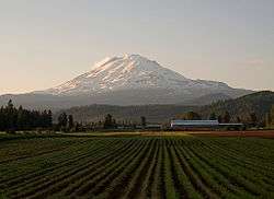
Trout Lake is in the northwest corner of Klickitat County, 14 miles (23 km) south of the 12,276-foot (3,742 m) summit of Mount Adams. State Route 141 passes through the community, traveling 22 miles (35 km) south to the town of White Salmon and 5 miles (8 km) west to its terminus at Gifford Pinchot National Forest.
According to the United States Census Bureau, the Trout Lake CDP has a total area of 7.0 square miles (18.1 km2), of which 0.04 square miles (0.1 km2), or 0.61%, are water.[3] The community sits in the Trout Lake Valley, drained to the southeast by Trout Lake Creek which flows to the White Salmon River, a south-flowing tributary of the Columbia River.
Climate
| Climate data for Trout Lake, Washington | |||||||||||||
|---|---|---|---|---|---|---|---|---|---|---|---|---|---|
| Month | Jan | Feb | Mar | Apr | May | Jun | Jul | Aug | Sep | Oct | Nov | Dec | Year |
| Record high °F (°C) | 02 (−17) |
01 (−17) |
74 (23) |
84 (29) |
97 (36) |
100 (38) |
102 (39) |
108 (42) |
98 (37) |
89 (32) |
70 (21) |
60 (16) |
108 (42) |
| Average high °F (°C) | 38 (3) |
43 (6) |
50 (10) |
59 (15) |
67 (19) |
74 (23) |
83 (28) |
83 (28) |
75 (24) |
60 (16) |
45 (7) |
36 (2) |
59 (15) |
| Average low °F (°C) | 25 (−4) |
26 (−3) |
29 (−2) |
33 (1) |
39 (4) |
44 (7) |
49 (9) |
48 (9) |
41 (5) |
34 (1) |
30 (−1) |
24 (−4) |
35 (2) |
| Record low °F (°C) | −24 (−31) |
−24 (−31) |
−7 (−22) |
15 (−9) |
20 (−7) |
28 (−2) |
28 (−2) |
28 (−2) |
11 (−12) |
2 (−17) |
−14 (−26) |
−20 (−29) |
−24 (−31) |
| Average precipitation inches (mm) | 7.36 (187) |
5.31 (135) |
5.50 (140) |
2.44 (62) |
1.65 (42) |
1.27 (32) |
0.45 (11) |
0.65 (17) |
1.11 (28) |
3.91 (99) |
7.78 (198) |
8.63 (219) |
46.06 (1,170) |
| Source: [4] | |||||||||||||
Demographics
As of the 2010 United States Census,[5] there were 557 people, 224 households, and 171 families residing in the CDP. The population density was 78.5 people per square mile. There were 290 housing units at an average density of 40.8/sq mi. The racial makeup of the CDP was 92.6% White, 0.2% Black, 0.9% Native American, 0.7% Asian, 2.5% from other races, and 3.1% from two or more races. Hispanic or Latino of any race were 5.2% of the population.
There were 224 households, out of which 28.1% included children under the age of 18, 64.7% included a married husband and wife, 4.0% included a male householder with no wife present, 7.6% had a female householder with no husband present, and 23.7% were non-families. The average household size was 2.46 and the average family size was 2.81.
The demographic spread included 130 (23.3%) under the age of 18, 329 (59.1%) aged 20 to 64, and 85 (15.3%) who were 65 years of age or older. By gender, the population was 51.7% (288) male and 48.3% (269) female. The median age was 44.8 years.
In 2011, the American Community Survey estimated a median income of $31,563 (adjusted for inflation, 2011 dollars) for an individual, and $56,250 for a household.[6]
References
- "U.S. Census website". United States Census Bureau. Retrieved 2008-01-31.
- "Trout Lake". Geographic Names Information System. United States Geological Survey.
- "Geographic Identifiers: 2010 Census Summary File 1 (G001), Trout Lake CDP, Washington". American FactFinder. U.S. Census Bureau. Archived from the original on February 13, 2020. Retrieved July 11, 2019.
- "weather.com".
- "U.S. Census website". United States Census Bureau. Retrieved 2011-05-14.
- "American Community Survey". US Census Bureau. Archived from the original on 2020-02-12.
External links
Municipalities and communities of Klickitat County, Washington, United States | ||
|---|---|---|
| Cities |  Map of Washington highlighting Klickitat County | |
| CDPs | ||
| Unincorporated communities | ||
| Ghost towns | ||
| Indian reservation | ||
| Footnotes | ‡This populated place also has portions in an adjacent county or counties | |