Mount Rainier National Park
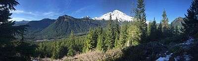
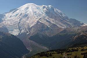
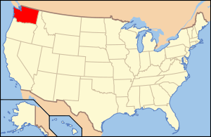
Mount Rainier National Park is an American national park located in southeast Pierce County and northeast Lewis County in Washington state.[3] The park was established on March 2, 1899 as the fifth national park in the United States, preserving 236,381 acres (369.3 sq mi; 956.6 km2)[1] including all of Mount Rainier, a 14,411-foot (4,392 m) stratovolcano.[4] The mountain rises abruptly from the surrounding land with elevations in the park ranging from 1,600 feet to over 14,000 feet (490–4,300 m). The highest point in the Cascade Range, Mount Rainier is surrounded by valleys, waterfalls, subalpine meadows, and 91,000 acres (142.2 sq mi; 368.3 km2) of old-growth forest.[5] More than 25 glaciers descend the flanks of the volcano, which is often shrouded in clouds that dump enormous amounts of rain and snow.
| Mount Rainier National Park | |
|---|---|
IUCN category II (national park) | |
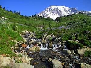 Mount Rainier from above Myrtle Falls | |
 Location in the United States 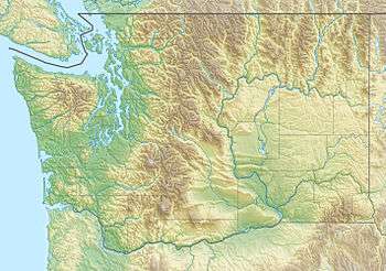 Location in Washington | |
| Location | Pierce County and Lewis County, Washington, United States |
| Nearest city | Tacoma |
| Coordinates | 46°51′N 121°45′W |
| Area | 236,381 acres (956.60 km2)[1] |
| Visitors | 1,518,491 (in 2018)[2] |
| Governing body | National Park Service |
| Website | Official website |
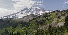
Mount Rainier is circled by the Wonderland Trail and is covered by glaciers and snowfields totaling about 35 square miles (91 km2). Carbon Glacier is the largest glacier by volume in the contiguous United States, while Emmons Glacier is the largest glacier by area. Mount Rainier is a popular peak for mountaineering with some 10,000 attempts per year with approximately 50% making it to the summit.
History
Ninety-seven percent of the park is preserved as wilderness under the National Wilderness Preservation System as Mount Rainier Wilderness, a designation it received in 1988. It is abutted by the Tatoosh, Clearwater, Glacier View, and William O. Douglas Wildernesses. The park was designated a National Historic Landmark on February 18, 1997 as a showcase for the National Park Service Rustic style architecture of the 1920s and 1930s, exemplified by the Paradise Inn and a masterpiece of early NPS master planning. As a Historic Landmark district, the park was administratively listed on the National Register of Historic Places.[6]
Native Americans
The earliest evidence of human activity in the area which is now Mount Rainier National Park, a projectile point dated to circa 4,000–5,800 BP (before present) found along Bench Lake Trail (the first section of Snow Lake Trail).[7][8]
A more substantial archeological find was a rock shelter near Fryingpan Creek, east of Goat Island Mountain. Hunting artifacts were found in the shelter. The shelter would not have been used all year round. Cultural affinities suggest the site was used by Columbia Plateau Tribes from 1000 to 300 BP.[7][8]
In 1963 the National Park Service contracted Washington State University to study Native American use of the Mount Rainier area. Richard D. Daugherty lead an archeological study of the area and concluded that prehistoric humans used the area most heavily between 8000 and 4500 BP. Allan H. Smith interviewed elderly Native Americans and studied ethnographic literature. He found no evidence of permanent habitation in the park area. The park was used for hunting and gathering and for occasional spirit quests. Smith also came to tentative conclusions that the park was divided among five tribes along watershed boundaries; the Nisqually, Puyallup, Muckleshoot, Yakama, and Taidnapam (Upper Cowlitz). Subsequent studies cast doubt on Smith's theory that the tribes had agreed upon boundaries before they entered into treaties with the United States in 1854–55.[7]
Flora
According to the A. W. Kuchler U.S. Potential natural vegetation types, Mount Rainier National Park has an Alpine Meadows & Barren, or Alpine tundra (52) potential vegetation type with an Alpine Meadow (11) potential vegetation form.[9]
Fauna
Mammals that inhabit this national park are especially the cougar, black bear, raccoon, coyote, bobcat, snowshoe hare, weasel, mole, beaver, red fox, porcupine, skunk, marmot, deer, marten, shrew, pika, elk, and mountain goat. The common birds of this park including raptors are the thrush, chickadee, kinglet, northern goshawk, willow flycatcher, spotted owl, steller's jay, Clark's nutcracker, bald eagle, ptarmigan, harlequin duck, grouse, peregrine falcon, Canada jay, golden eagle, grosbeak and finch.
Park creation
On March 2, 1899, President William McKinley signed a bill passed by Congress authorizing the creation of Mount Rainier National Park, the nation's fifth national park.[11] It was the first national park created from a national forest.[10] The Pacific Forest Reserve had been created in 1893 and included Mount Rainier. It was enlarged in 1897 and renamed Mount Rainier Forest Reserve. John Muir had visited Mount Rainier in 1888. Muir and nine others, including Edward Sturgis Ingraham, Charles Piper, and P. B. Van Trump, climbed to the summit in what became the fifth recorded ascent.[12][13]
The trip to Mount Rainier had played a role in reinvigorating Muir and convincing him to rededicate his life to the preservation of nature as national parks. At the time national forests, called forest reserves at first, were being created throughout the American West, under the utilitarian "conservation-through-use" view of Gifford Pinchot. Muir came to be known as a "preservationist". He wanted nature preserved under the more protected status of national parks. But during the 1890s there was more public support for creating national forests than national parks. During that decade, Muir and his supporters were only able to protect one national forest as a national park. When the Pacific Forest Reserve was created in 1893, Muir quickly persuaded the newly formed Sierra Club to support a movement to protect Rainier as a national park. Other groups soon joined, such as the National Geographic Society and scientific associations wanting Mount Rainier preserved as a place to study volcanism and glaciology. Commercial leaders in Tacoma and Seattle were also in support, as was the Northern Pacific Railway. The effort lasted over five years and involved six different attempts to push a bill through Congress. Congress eventually agreed, but only after acquiring assurances that none of the new park was suitable for farming or mining and that no federal appropriations would be necessary for its management.[10]
2006 flooding
Mount Rainier National Park closed because of extensive flooding as a result of the 6 November 2006 Pineapple Express rainstorm when 18 inches (460 mm) of rain fell in a 36-hour period. Campsites and roads throughout the park were washed away. Power to Paradise and Longmire was disrupted. Sunshine Point Campground, just inside the Nisqually Entrance, was destroyed and has not reopened.[14] On 5 May 2007, the park reopened to automobile traffic via State Route 706 at the Nisqually Entrance.[15]
Climate
According to the Köppen climate classification system, the best definition for Mount Rainier National Park is Mediterranean-influenced Subarctic climate (‘’Dsc’’). ‘’Dsc” climates are defined by their coldest month averaging below 0 °C (32 °F), 1–3 months averaging above 10 °C (50 °F), at least three times as much precipitation in the wettest month of winter as in the driest month of summer. According to the United States Department of Agriculture, the Plant Hardiness zone at Sunrise Visitor Center (6,398 feet (1,950 m) elevation) is 6a with an average annual extreme minimum temperature of -5.5 °F (-20.8 °C).[16]
The National Park Service says that "Paradise is the snowiest place on Earth where snowfall is measured regularly."[17] During the winter of 1971/72 1,122 inches (28.5 m) of snow fell, setting a world record for that year.[17][18] Subsequently, in the winter of 1998/99, Mount Baker Ski Area received 1,140 inches (29 m).[19] Paradise holds the Cascade Range record for most snow on the ground with 367 inches (9.32 m) on 10 March 1956.[20]
| Climate data for Paradise Ranger Station (1981–2010) | |||||||||||||
|---|---|---|---|---|---|---|---|---|---|---|---|---|---|
| Month | Jan | Feb | Mar | Apr | May | Jun | Jul | Aug | Sep | Oct | Nov | Dec | Year |
| Record high °F (°C) | 65 (18) |
62 (17) |
70 (21) |
78 (26) |
88 (31) |
86 (30) |
87 (31) |
94 (34) |
89 (32) |
88 (31) |
78 (26) |
66 (19) |
94 (34) |
| Average high °F (°C) | 34.9 (1.6) |
35.7 (2.1) |
37.9 (3.3) |
42.1 (5.6) |
49.3 (9.6) |
54.7 (12.6) |
63.3 (17.4) |
64.5 (18.1) |
58.1 (14.5) |
47.9 (8.8) |
37.3 (2.9) |
33.8 (1.0) |
46.6 (8.1) |
| Daily mean °F (°C) | 28.7 (−1.8) |
28.9 (−1.7) |
30.8 (−0.7) |
34.0 (1.1) |
40.5 (4.7) |
45.5 (7.5) |
53.0 (11.7) |
54.2 (12.3) |
48.9 (9.4) |
40.1 (4.5) |
31.0 (−0.6) |
27.4 (−2.6) |
38.6 (3.7) |
| Average low °F (°C) | 22.5 (−5.3) |
22.1 (−5.5) |
23.7 (−4.6) |
25.9 (−3.4) |
31.8 (−0.1) |
36.2 (2.3) |
42.7 (5.9) |
43.9 (6.6) |
39.7 (4.3) |
32.3 (0.2) |
24.7 (−4.1) |
21.1 (−6.1) |
30.6 (−0.8) |
| Record low °F (°C) | −13 (−25) |
−18 (−28) |
−2 (−19) |
2 (−17) |
13 (−11) |
13 (−11) |
20 (−7) |
26 (−3) |
18 (−8) |
2 (−17) |
−11 (−24) |
−20 (−29) |
−20 (−29) |
| Average precipitation inches (mm) | 18.24 (463) |
12.69 (322) |
12.56 (319) |
8.30 (211) |
5.89 (150) |
4.11 (104) |
1.95 (50) |
1.97 (50) |
4.71 (120) |
10.43 (265) |
20.28 (515) |
17.17 (436) |
118.3 (3,005) |
| Average snowfall inches (cm) | 118.7 (301) |
91.6 (233) |
90.6 (230) |
67.5 (171) |
26.1 (66) |
5.6 (14) |
0.3 (0.76) |
0.1 (0.25) |
1.4 (3.6) |
24.1 (61) |
120.9 (307) |
124.0 (315) |
670.9 (1,702.61) |
| Average precipitation days (≥ 0.01 in) | 21.1 | 17.8 | 21.5 | 18.8 | 15.4 | 12.8 | 7.3 | 6.6 | 9.6 | 15.0 | 21.7 | 21.1 | 188.7 |
| Average snowy days (≥ 0.1 in) | 18.5 | 15.9 | 19.5 | 14.4 | 7.9 | 2.5 | 0.2 | 0.1 | 0.7 | 6.2 | 16.6 | 19.0 | 121.5 |
| Source 1: NOAA (normals, 1981–2010)[21] | |||||||||||||
| Source 2: Western Regional Climate Center (extremes 1916–present)[22] | |||||||||||||
| Climate data for Sunrise Visitor Center, Mount Rainier National Park. (Elev: 6309 ft / 1923 m) 1981–2010 | |||||||||||||
|---|---|---|---|---|---|---|---|---|---|---|---|---|---|
| Month | Jan | Feb | Mar | Apr | May | Jun | Jul | Aug | Sep | Oct | Nov | Dec | Year |
| Average high °F (°C) | 30.5 (−0.8) |
32.1 (0.1) |
35.2 (1.8) |
39.8 (4.3) |
46.4 (8.0) |
51.9 (11.1) |
60.8 (16.0) |
61.8 (16.6) |
56.1 (13.4) |
44.7 (7.1) |
33.8 (1.0) |
29.6 (−1.3) |
43.6 (6.4) |
| Daily mean °F (°C) | 24.9 (−3.9) |
25.3 (−3.7) |
27.5 (−2.5) |
31.4 (−0.3) |
37.6 (3.1) |
43.0 (6.1) |
50.7 (10.4) |
51.6 (10.9) |
46.9 (8.3) |
37.3 (2.9) |
28.2 (−2.1) |
24.1 (−4.4) |
35.8 (2.1) |
| Average low °F (°C) | 19.4 (−7.0) |
18.5 (−7.5) |
19.9 (−6.7) |
23.0 (−5.0) |
28.8 (−1.8) |
34.1 (1.2) |
40.6 (4.8) |
41.3 (5.2) |
37.7 (3.2) |
29.8 (−1.2) |
22.6 (−5.2) |
18.6 (−7.4) |
27.9 (−2.3) |
| Average precipitation inches (mm) | 11.84 (301) |
8.73 (222) |
8.12 (206) |
5.52 (140) |
3.80 (97) |
4.08 (104) |
1.83 (46) |
1.22 (31) |
2.93 (74) |
5.29 (134) |
12.38 (314) |
13.19 (335) |
78.93 (2,005) |
| Average relative humidity (%) | 80.0 | 74.7 | 69.4 | 72.6 | 68.6 | 68.1 | 69.0 | 66.7 | 65.7 | 68.0 | 79.6 | 80.3 | 71.9 |
| Average dew point °F (°C) | 19.6 (−6.9) |
18.4 (−7.6) |
18.8 (−7.3) |
23.6 (−4.7) |
28.2 (−2.1) |
33.2 (0.7) |
40.9 (4.9) |
40.9 (4.9) |
36.0 (2.2) |
27.7 (−2.4) |
22.7 (−5.2) |
18.9 (−7.3) |
27.5 (−2.5) |
| Source: PRISM Climate Group[23] | |||||||||||||
Major attractions
The entire park was designated a National Historic Landmark District on February 18, 1997, in recognition of the consistently high standard of design and preservation the park's National Park Service Rustic-style architecture.[24] The park contains 42 locations designated on the National Register of Historic Places, including four National Historic Landmarks.
Paradise
Paradise (46.79°N 121.74°W[25]) is the name of an area at approximately 5,400 feet (1,600 m) on the south slope of Mount Rainier in the national park. Paradise is the most popular destination for visitors to Mount Rainier National Park.[26] 62% of the over 1.3 million people who visited the park in 2000 went to Paradise.[27] Paradise, near the subalpine valley of the Paradise River, is the location of the historic Paradise Inn (built 1916),[28] Paradise Guide House (built 1920) and Henry M. Jackson Visitor Center (built 1966;[29] demolished and replaced, 2008). [30]
Longmire
.jpg)
Longmire (46.75°N 121.81°W) is a visitor center in Mount Rainier National Park, located 6.5 miles (10.5 km) east of the Nisqually Entrance. The area is named after James Longmire, an early settler in Puget Sound. The area is in the Nisqually River valley at an elevation of 2,761 feet (842 m)[31] between The Ramparts Ridge and the Tatoosh Range. Longmire is surrounded by old-growth Douglas fir, western red cedar and western hemlock.
Longmire is the location of Mount Rainier's National Park Inn, the Longmire Museum, and the 1928 National Park Service Administration Building, which is now a Wilderness Information Center. The National Park Inn is the only accommodation in the park open all year round.[32]
Longmire is the second most popular destination for visitors to Mount Rainier National Park after Paradise. Of the more than 1.3 million people who visited the park in 2000, 38% visited Longmire.[27] The Cougar Rock Campground is about 2 miles (3.2 km) north west of Longmire [3] with 173 individual campsites and 5 group sites and open from late May through late September. Longmire is one of the starting points of the Wonderland Trail.
Sunrise
Sunrise (46.91°N 121.64°W) is a lodge and visitor center located in the northeastern part of the park. At an elevation of 6,400 feet (1,950 m), it is the highest point in the park that is accessible by vehicle. There are miles of trails located all around Sunrise, such as Mount Fremont, Burroughs Mountain, and Sourdough Ridge. The lodge is reachable via a 10-mile (16 km) turnoff from SR 410 near the White River entrance.
Other developed areas

Ohanapecosh /oʊˈhænəpɪkɔːʃ/ is a campground (with 188 individual sites and 2 group sites, open from late May through late September), visitor center (closed during the 2013 season), and ranger station located in the southeastern portion of the park, approximately 3 miles (4.8 km) from the park boundary off Highway 123. Located in a deep valley among old growth forest at an elevation below 2,000 feet (610 m), it is the only developed area of the park without a view of Mount Rainier. The Ohanapecosh Hot Springs, Grove of the Patriarchs, and Silver Falls are all located in the Ohanapecosh area.
The Carbon River Entrance Station is located in the northwest corner of the park off Highway 165 and is the site of the only rainforest at Mount Rainier. There is a campground and a short trail through the rainforest, as well as a trail to the Carbon Glacier, one of the lowest glaciers in the contiguous United States.
Mowich Lake is the largest and deepest lake in the park, located south of Carbon at the south end of Highway 165. A campground, picnic area, and hiking trail are located near the lake.
The two major roads into the northwest quadrant of the Park were severely damaged by the floods of 2006. The ranger station at the Carbon River entrance is staffed during the summer. No motor vehicles are permitted beyond that point.
See also
![]()
References
- "Listing of acreage as of December 31, 2011". Land Resource Division, National Park Service. Retrieved 2012-03-07.
- "NPS Annual Recreation Visits Report". National Park Service. Retrieved 2019-03-08.
- Mount Rainier National Park (Map) (Centennial ed.). 1:30,000. Cartography by Charles B. Kitterman/Kulshan Cartographic Services. Stanley Maps. 2000. ISBN 0-9662209-4-3.
- http://www.nps.gov/mora/naturescience/index.htm
- Bolsinger, Charles L.; Waddell, Karen L. (1993). Area of old-growth forests in California, Oregon, and Washington (PDF). United States Forest Service, Pacific Northwest Research Station. Resource Bulletin PNW-RB-197.
- "Mount Rainier National Park". National Historic Landmark summary listing. National Park Service. Archived from the original on 2008-06-21. Retrieved 2008-06-26.
- "Part One: The Cultural Setting. I. Historical Overview Of Indians And Mount Rainier". Mount Rainier Administrative History. National Park Service. 24 July 2000. Retrieved 2007-06-05.
- Burtchard, Greg C. (17 November 2004) [February 1998]. "Chapter 4: The 1995 Mount Rainier Archeological Reconnaissance". Environment, Prehistory & Archaeology of Mount Rainier National Park, Washington. with contributions by Stephen C. Hamilton and Richard H. McClure, Jr. National Park Service, Seattle, Washington; International Archaeological Research Institute, Inc. Retrieved 2007-06-05.
- "U.S. Potential Natural Vegetation, Original Kuchler Types, v2.0 (Spatially Adjusted to Correct Geometric Distortions)". Data Basin. Retrieved 2019-07-15.
- Duncan, Dayton; Burns, Ken (2009). The National Parks: America's Best Idea. Random House. pp. 48–51, 84–86. ISBN 978-0-307-26896-9.
- Carson, Rob; Hill, Craig. "Rainier Timeline". The News Tribune. Archived from the original on 13 August 2011. Retrieved 24 July 2010.
- "Chronology of Climbs on Mt. Rainier". Tacoma Public Library. Archived from the original on 1 July 2013. Retrieved 24 July 2010.
- "Transcribed from "John Muir's Ascent of Mt. Rainier"". University of Washington. Archived from the original on 25 April 2001. Retrieved 24 July 2010.
- "November 2006 Flooding". Mount Rainier National Park. Retrieved 2007-05-30.
- Carlton Harrell, Debera (5 May 2007). "Battered Mt. Rainier to reopen". Seattle Post-Intelligencer. Retrieved 2007-05-22.
- "USDA Interactive Plant Hardiness Map". United States Department of Agriculture. Retrieved 2019-07-15.
- "Mount Rainier National Park - Frequently Asked Questions (U.S. National Park Service)". National Park Service. 19 January 2007 [4 August 2005]. Retrieved 2007-05-22.
- "Annual Snowfall at Paradise 1920 to 2002" (PDF). National Park Service. 12 January 2007. Retrieved 2007-05-22.
- "Mt. Baker Holds Snowfall Record, NOAA reports". NOAA. 2 August 1999. Archived from the original on 7 January 2013. Retrieved 2011-09-16.
- Andalkar, Amar (April 2006) [December 2002]. "Skiing the Cascade Volcanoes". Amar Andalkar's Ski Mountaineering and Climbing Site. Retrieved 2007-05-30.
- "WA Rainier Paradise RS". National Oceanic and Atmospheric Administration. Retrieved October 27, 2013.
- "RAINIER PARADISE RNG, WASHINGTON". Western Regional Climate Center.
- "PRISM Climate Group, Oregon State University". www.prism.oregonstate.edu. Retrieved July 15, 2019.
- "National Register of Historic Places Nomination Form: Historic Resources of Mount Rainier National Park MPS" (PDF). National Park Service. Archived from the original (PDF) on 15 March 2012. Retrieved 7 April 2011.
- Mount Rainier East, Washington (Map). 1 : 24,000. 7,5 Minute Series (Topographic). United States Geological Survey. 1971. ISBN 0-607-01198-X. Coordinate measured using National Geographic TOPO! Software Version 3.4.3.
- Pitcher, Don (2002). Moon Handbooks Washington. Moon Handbooks (7th ed.). Avalon Travel Publishing. pp. 615–616. ISBN 1-56691-386-1.
- "Mount Rainier National Park Visitor Study Brochure" (PDF). Visitor Services Project. National Park Service. 31 March 2003. Retrieved 2007-05-22.
- Barnes, Christine; Pfulghoft, Fred (Photographer); Morris, David (Photographer) (2002). Great Lodges of the National Parks: The Companion Book to the PBS Television Series. W W West. pp. 48–57. ISBN 0-9653924-5-7.
- "Mt. Rainier National Park Centennial Timeline 1960s". Mount Rainier National Park Centennial Celebration. National Park Service. 1999. Retrieved 2007-05-22.
1966: The Paradise Visitor Center (in 1987 dedicated as the Henry M. Jackson Visitor Center), is opened to the public in September.
- Doughton, Sandi (10 October 2008). "Paradise rediscovered – new Mount Rainier visitor center opens". Seattle Times website. Seattle Times. Archived from the original on 13 October 2008. Retrieved 2009-07-27.
The new visitor center, at the park's premier destination, opens today.
- Filley, Bette (2002). Discovering the Wonders of the Wonderland Trail: Encircling Mount Rainier (5th edition). Dunamis House. p. 37. ISBN 1-880405-09-1.
- Scott, Kay W.; Scott, David L. (2002). The Complete Guide to the National Park Lodges, 3rd. Globe Pequot. pp. 193–194. ISBN 0-7627-1197-3.
External links
- Official website

- Static park map and interactive park maps
- NPS park history documents – natural and cultural history of the park
- National Historic Landmark information (archive)
- University of Washington Libraries – black-and-white photographs from a promotional album (ca. 1925)
| Lists by county |
|  |
|---|---|---|
| Other lists |
| |
| Authority control |
|
|---|