Falher
Falher (/fəˈlɛər/, fə-LAIR)[6] is a town in the Peace Country area of Alberta, Canada. It is located in the Municipal District of Smoky River No. 130, along Highway 49. Falher is one of the earliest agricultural communities in the Peace River Country.
Falher | |
|---|---|
Town | |
| Town of Falher Ville de Falher | |
 Main street | |
 Flag | |
 Falher Location of Falher in Alberta | |
| Coordinates: 55°44′14″N 117°12′05″W | |
| Country | |
| Province | |
| Region | Northern Alberta |
| Census division | 19 |
| Municipal district | Municipal District of Smoky River No. 130 |
| Incorporated[1] | |
| • Village | September 5, 1923 |
| • Dissolution | August 9, 1926 |
| • Village | March 13, 1929 |
| • Town | January 1, 1955 |
| Government | |
| • Mayor | Donna Buchinski |
| • Governing body | Falher Town Council |
| Area (2016)[3] | |
| • Land | 2.78 km2 (1.07 sq mi) |
| Elevation | 587 m (1,926 ft) |
| Population (2016)[3] | |
| • Total | 1,047 |
| • Density | 376.4/km2 (975/sq mi) |
| Time zone | UTC−7 (MST) |
| • Summer (DST) | UTC−6 (MDT) |
| Area code(s) | +1-780 |
| Highways | Highway 49 Highway 2 |
| Website | Official website |
| [5] | |
History
The area was known to missionaries before it was surveyed in 1909 as an Indian trail that led to British Columbia and later where the railway laid its tracks. In 1912, the settlement of Mission St-Jean Baptiste de Falher was opened 5 km (3.1 mi) from the current location of the Town of Falher. When the railway came to the area in 1915, the settlement was named after Father Constant Falher, a Roman Catholic Oblate missionary who was born in Josselin, Brittany, France in 1863, arriving at Grouard in 1889. The origin of the majority of local colonizers were from Quebec; some arriving in the area via the United States of America (French American), such as Robert Goulet's family, who settled in the nearby francophone community.
The colony was divided into two: what is now the Village of Donnelly and the Town of Falher. In 1919, the town consolidated a school district and the first parish of Ste. Anne was established. The first post office opened in 1923 when the settlement became a hamlet. It incorporated as a village in 1929 and then as a town in 1955.
Demographics
| Federal census population history | ||
|---|---|---|
| Year | Pop. | ±% |
| 1926 | 128 | — |
| 1931 | 253 | +97.7% |
| 1936 | 284 | +12.3% |
| 1941 | 244 | −14.1% |
| 1946 | 279 | +14.3% |
| 1951 | 575 | +106.1% |
| 1956 | 802 | +39.5% |
| 1961 | 741 | −7.6% |
| 1966 | 843 | +13.8% |
| 1971 | 935 | +10.9% |
| 1976 | 1,120 | +19.8% |
| 1981 | 1,102 | −1.6% |
| 1986 | 1,178 | +6.9% |
| 1991 | 1,183 | +0.4% |
| 1996 | 1,149 | −2.9% |
| 2001 | 1,109 | −3.5% |
| 2006 | 941 | −15.1% |
| 2011 | 1,075 | +14.2% |
| 2016 | 1,047 | −2.6% |
| Source: Statistics Canada [7][8][9][10][11][12][13][14][3] | ||
In the 2016 Census of Population conducted by Statistics Canada, the Town of Falher recorded a population of 1,047 living in 450 of its 482 total private dwellings, a -2.6% change from its 2011 population of 1,075. With a land area of 2.78 km2 (1.07 sq mi), it had a population density of 376.6/km2 (975.4/sq mi) in 2016.[3]
In the 2011 Census, the Town of Falher had a population of 1,075 living in 497 of its 522 total dwellings, a 14.2% change from its 2006 population of 941. With a land area of 2.87 km2 (1.11 sq mi), it had a population density of 374.6/km2 (970.1/sq mi) in 2011.[15]
Economy
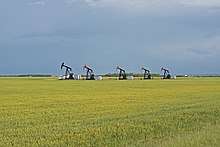
The principal industries in the area are agriculture, forestry, oil and gas.
Established in 1973 as a private business, Falher Alfalfa (an alfalfa processing facility) was sold to a group of producers and farmers in 1978 with the same company. Under normal circumstances, Falher Alfalfa employed a staff of about 35 full-time employees in the spring and 110 at the busiest time of the season. Falher Alfalfa went under the Company Creditor Arrangement Act in June 2007, protecting the company against any legal action taken by creditors and gave the company a chance to sell its product to be able to repay creditors. In spring 2008, Falher Alfalfa declared bankruptcy due to production costs.[16]
Government
The Town of Falher is governed by a mayor (Donna Buchinski) and five councillors who meet on the second Monday of each month.[17] It is currently located in the riding of Peace River—Westlock [18] federally.
Arts and culture
Every year, a "Honey Festival" is held to pay tribute to the beekeeping industry which has created an impact in the Smoky River region and throughout Canada and the United States. The honey in the area is derived largely from clover seed operations. At its peak, more than 48,000 hives in the region produced 10 million pounds (4,500 t) of honey annually. Today the honey of the Smoky River Region is known worldwide.
Falher attracted national attention in 2006 due to its high standing in the "Kraft Hockeyville"[19] contest, a coast-to-coast competition to elect the municipality that most embodies the spirit of Canada's national pastime.
Attractions
Main Street Falher includes a large honey bee statue, as Falher is known as "Honey Capital of Canada". The statue was built by local welder, Richard Ethier and it measures 22 feet 8 inches (6.91 m), and its diameter is 7 feet 7 inches (2.31 m).[20] There is also a tall slide next to an arena where the local hockey team, The Falher Pirates, play against other teams in the division.
Education
There are two public schools in Falher:
- École Héritage School[21] is a Francophone school that is located in a building that once served as a college school built by the Oblates in 1951. École Héritage currently has students in grades K–12.
- École Routhier School is another educational institution in Falher. Routhier is an Anglophone and French immersion Elementary School which includes grades K–6.
Students in grades 7-12 attend classes at École Georges P. Vanier School in nearby Donnelly, Alberta.
Media
Falher is home to a French-language radio station, CKRP-FM, and is served bi-weekly by an alternative newspaper, The Vault Magazine.[22]
There is also a local news service known as The Smoky River Express.
References
- "Location and History Profile: Town of Falher" (PDF). Alberta Municipal Affairs. October 7, 2016. p. 246. Retrieved October 16, 2016.
- "Municipal Officials Search". Alberta Municipal Affairs. 2017-09-22. Retrieved 2017-09-25.
- "Population and dwelling counts, for Canada, provinces and territories, and census subdivisions (municipalities), 2016 and 2011 censuses – 100% data (Alberta)". Statistics Canada. February 8, 2017. Retrieved February 8, 2017.
- "Alberta Private Sewage Systems 2009 Standard of Practice Handbook: Appendix A.3 Alberta Design Data (A.3.A. Alberta Climate Design Data by Town)" (PDF) (PDF). Safety Codes Council. January 2012. pp. 212–215 (PDF pages 226–229). Retrieved October 8, 2013.
- "Falher". Geographical Names Data Base. Natural Resources Canada.
- The Canadian Press (2017), The Canadian Press Stylebook (18th ed.), Toronto: The Canadian Press
- "Table 5: Population of urban centres, 1916-1946, with guide to locations". Census of the Prairie Provinces, 1946. Volume I: Population. Ottawa: Dominion Bureau of Statistics. 1949. pp. 397–400.
- "Table 6: Population by sex, for census subdivisions, 1956 and 1951". Census of Canada, 1956. Volume I: Population. Ottawa: Dominion Bureau of Statistics. 1958.
- "Table 9: Population by census subdivisions, 1966 by sex, and 1961". 1966 Census of Canada. Western Provinces. Population: Divisions and Subdivisions. Ottawa: Dominion Bureau of Statistics. 1967.
- "Table 3: Population for census divisions and subdivisions, 1971 and 1976". 1976 Census of Canada. Census Divisions and Subdivisions, Western Provinces and the Territories. Population: Geographic Distributions. Ottawa: Statistics Canada. 1977.
- "Table 2: Census Subdivisions in Alphabetical Order, Showing Population Rank, Canada, 1981". 1981 Census of Canada. Census subdivisions in decreasing population order. Ottawa: Statistics Canada. 1982. ISBN 0-660-51563-6.
- "Table 2: Population and Dwelling Counts, for Census Divisions and Census Subdivisions, 1986 and 1991 – 100% Data". 91 Census. Population and Dwelling Counts – Census Divisions and Census Subdivisions. Ottawa: Statistics Canada. 1992. pp. 100–108. ISBN 0-660-57115-3.
- "Population and Dwelling Counts, for Canada, Provinces and Territories, and Census Divisions, 2001 and 1996 Censuses – 100% Data (Alberta)". Statistics Canada. Retrieved 2019-05-25.
- "Population and dwelling counts, for Canada, provinces and territories, and census subdivisions (municipalities), 2006 and 2001 censuses – 100% data (Alberta)". Statistics Canada. January 6, 2010. Retrieved 2019-05-25.
- "Population and dwelling counts, for Canada, provinces and territories, and census subdivisions (municipalities), 2011 and 2006 censuses (Alberta)". Statistics Canada. 2012-02-08. Retrieved 2012-02-08.
- Smoky River Express. Falher Alfalfa closes after going into receivership Archived 2008-09-07 at the Wayback Machine
- "Falher - Town Council". Retrieved 2014-12-31.
- "Map of Peace River-Westlock Electoral District". Retrieved 2014-12-31.
- CBC. "Hockeyville". CBC News. Retrieved 2007-01-19.
- Town of Falher. "World's Largest Bee". Archived from the original on 2008-02-27. Retrieved 2008-04-02.
- École Héritage School
- "Archived copy". Archived from the original on 2015-04-25. Retrieved 2015-05-22.CS1 maint: archived copy as title (link)
External links

- Official website

Places adjacent to Falher | ||||||||||
|---|---|---|---|---|---|---|---|---|---|---|
| ||||||||||