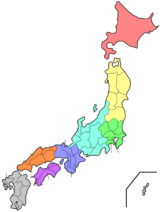
Mie Prefecture
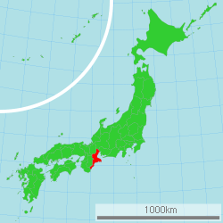
Mie Prefecture (三重県, Mie-ken) is a prefecture of Japan located in the Kansai region of Honshu.[1] Mie Prefecture has a population of 1,781,948 (1 June 2019) and has a geographic area of 5,774 km² (2,229 sq mi). Mie Prefecture borders Gifu Prefecture to the north, Shiga Prefecture and Kyoto Prefecture to the northwest, Nara Prefecture to the west, Wakayama Prefecture to the southwest, and Aichi Prefecture to the east.
Mie Prefecture 三重県 | |
|---|---|
| Japanese transcription(s) | |
| • Japanese | 三重県 |
| • Rōmaji | Mie-ken |
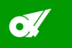 Flag  Symbol | |
 | |
| Coordinates: 34°42′N 136°30′E | |
| Country | Japan |
| Region | Kansai (Tōkai) |
| Island | Honshu |
| Capital | Tsu |
| Subdivisions | Districts: 7, Municipalities: 29 |
| Government | |
| • Governor | Eikei Suzuki (since April 2011) |
| Area | |
| • Total | 5,774.41 km2 (2,229.51 sq mi) |
| Area rank | 25th |
| Population (June 1, 2019) | |
| • Total | 1,781,948 |
| • Rank | 23rd |
| • Density | 310/km2 (800/sq mi) |
| ISO 3166 code | JP-24 |
| Website | www.pref.mie.jp/ ENGLISH/ |
| Symbols | |
| Bird | Snowy plover (Charadrius alexandrinus) |
| Fish | Japanese spiny lobster (Panulirus japonicus) |
| Flower | Iris (Iris ensata) |
| Tree | Japanese cedar (Cryptomeria japonica) |
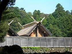
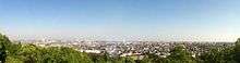
Tsu is the capital and Yokkaichi is the largest city of Mie Prefecture, with other major cities including Suzuka, Matsusaka, and Kuwana.[2] Mie Prefecture is located on the eastern coast of the Kii Peninsula, forming the western side of Ise Bay which features the mouths of the Kiso Three Rivers. Mie Prefecture is a popular tourism destination home to Nagashima Spa Land, Suzuka International Racing Course, and some of the oldest and holiest sites in Shinto, the traditional religion of Japan, including the Ise Grand Shrine and the Tsubaki Grand Shrine.
History
Until the Meiji Restoration, the area that is now Mie Prefecture was made up of Ise Province, Shima Province, Iga Province, and part of Kii Province.[3]
Evidence of human habitation in Mie dates back more than 10,000 years. During the Jōmon and Yayoi periods, agricultural communities began to form along the river and coastal areas of the region. Ise Shrine is said to have been established during the Yayoi period, and in the 7th century the Saikū Imperial Residence was built in what is now Meiwa Town to serve as both a residence and administrative centre for the Saiō, an Imperial Princess who served as High Priestess of Ise Shrine.
During the Edo period, the area now known as Mie Prefecture consisted of several feudal domains, each ruled by an appointed lord. Transport networks, including the Tokaido and Ise Roads, were built. Port towns such as Ohminato, Kuwana and Anōtsu, posting stations and castle towns flourished. Pilgrimages to Ise Shrine also became very popular.
After the Meiji Restoration, the former provinces of Ise, Shima and Iga as well as a portion of eastern Kii, were organized and reorganized repeatedly. In 1871 the area from the Kiso Three Rivers in the north to present-day Tsu became Anōtsu Prefecture, and the area south of that became Watarai Prefecture. In 1872, the Anōtsu prefectural seat moved from Tsu to Yokkaichi, and the prefecture itself was renamed Mie. For a variety of reasons, including the strong likelihood that Mie would eventually merge with Watarai, the prefectural seat returned to Tsu the following year, and Mie Prefecture took its present-day form in 1876, when it merged with its southern neighbor.
The name Mie supposedly was taken from a comment about the region made by Yamato Takeru on his way back from conquering the eastern regions.
In 1959 many lives were lost as parts of Mie were devastated by the Ise-wan Typhoon, the strongest typhoon to hit Japan in recorded history. Crops were destroyed, sea walls ruined, roads and railways damaged and a substantial number of people were injured or left homeless.
In May 2016, the city of Shima hosted the 42nd G7 summit, the third summit without the presence of Russia.
Geography

City Town
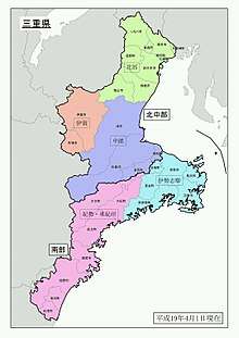
Japan Meteorological Agency]]: The primary division is between North/Central and South, the former being further subdivided into North, Central and Iga, the latter into Ise-Shima and KiSei/East Kishū; Ise/Sei[-shū], Shima/Shi[-shū], Iga/I[-shū) and Kii/Ki[-shū] are the four Ritsuryō provinces that are partly or entirely part of modern Mie.]]
Mie Prefecture forms the eastern part of the Kii Peninsula, and borders on Aichi, Gifu, Shiga, Kyoto, Nara, and Wakayama. It is considered part of the Kansai and Tōkai regions due to its geographical proximity to Aichi Prefecture and its cultural influence from Kansai, such as the fact that Kansai dialect is spoken in Mie. Traditionally, though, the Iga region of Mie is considered to have always been a part of Kansai.
Mie Prefecture measures 170 km (106 mi) from north to south, and 80 km (50 mi) from east to west, and includes five distinct geographical areas:[4]
- the north-west of Mie consists of the Suzuka Mountains
- along the coast of Ise Bay from the Aichi border to Ise City lies the Ise Plain, where most of the population of Mie live
- south of the Ise Plain is the Shima Peninsula
- bordering Nara in the central-west is the Iga Basin
- running from central Mie to its southern borders is the Nunobiki Mountainous Region.
Toba, Mie|Toba]]]]
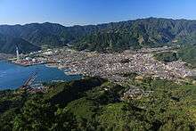
Owase, Mie|Owase]]]]
Mie has a coastline that stretches 1,094.9 km (680.3 mi) and, as of 2000, Mie's 5,776.44 km2 (2,230.30 sq mi) landmass is 64.8% forest, 11.5% agriculture, 6% residential area, 3.8% roads, and 3.6% rivers. The remaining 10.3% are not classified.
The Ise Plain has a relatively moderate climate, averaging 14 to 15 degrees Celsius for the year. The Iga Basin has more daily temperature variance and averages temperatures 1 to 2 degrees cooler than the Ise Plain. Southern Mie, south of the Shima Peninsula, has a warmer Pacific marine climate, with Owase Region having one of the heaviest rainfall figures for all of Japan.[4]
As of 31 March 2019, 36% of the total area of the prefecture comprised designated Natural Parks,[5] namely:
- Ise-Shima National Park
- Yoshino-Kumano National Park
- Murō-Akame-Aoyama Quasi-National Park
- Suzuka Quasi-National Park
- Akame Ichishikyō Prefectural Natural Park
- Ise-no-Umi Prefectural Natural Park
- Kahadakyō Prefectural Natural Park
- Okuise Miyagawakyō Prefectural Natural Park
- Suigō Prefectural Natural Park
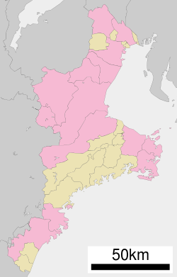
Cities
Fourteen cities are located in Mie Prefecture:
Towns
These are the towns in each district:
Mergers
Economy
Mie Prefecture has traditionally been a link between east and west Japan, thanks largely to the Tokaido and Ise Pilgrimage Roads. Traditional handicrafts such as Iga Braid, Yokkaichi Banko Pottery, Suzuka Ink, Iga Pottery and Ise Katagami flourished. With 65% of the prefecture consisting of forests and with over 1,000 km (600 mi) of coastline, Mie has a long been associated with forestry and seafood industries. Mie also produces tea, beef, cultured pearls and fruit, mainly mandarin oranges. Food production companies include Azuma Foods.[6][7]
Northern Mie is home to a number of manufacturing industries, mainly transport machinery manufacturing (vehicles and ships) and heavy chemical industries such as oil refineries. As well as this, Mie Prefecture is expanding into more advanced industries including the manufacture of semiconductors and liquid crystal displays. In Suzuka, the Honda Motor Company maintains a factory established in 1960 that built the Honda Civic as well as other vehicles.
Demographics
| Mie Prefecture Demographics (as of 2014)[8] | |
|---|---|
| Total population | 1,820,491 |
| Male population | 886,362 |
| Female population | 934,129 |
| Population aged under 15 | 240,263 |
| Population aged 15 to 64 | 1,076,257 |
| Population aged over 64 | 491,779 |
| Households | 721,344 |
| Population density (per km2) | 315.3 |
Culture
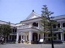
Universities
- Yokkaichi
- Suzuka
- Suzuka International University
- Suzuka University of Medical Science
- Suzuka National College of Technology
- Tsu
- Matsusaka
- Ise
- Toba
Transportation
Rail
- JR Central
- Kansai Line (Nagoya-Kameyama)
- Kisei Line
- Sangu Line
- JR West
- Kansai Line (Kameyama-Nara)
- Kusatsu Line (Tsuge Station)
- Kintetsu
- Nagoya Line
- Osaka Line
- Yamada Line
- Toba Line
- Shima Line
- Yunoyama Line
- Uchibe Line
- Hachioji Line
- Suzuka Line
- Yoro Railway
- Iga Railway
- Ise Railway
- Sangi Railway
Road
Expressways and toll roads
- East Meihan Expressway
- Second Meishin Expressway
- Ise Expressway
- Ise Bayside Expressway
- Kisei Expressway
- Meihan National Highway
- Ise Shima Skyline
- Ise Futami Toba Road
- Kumano Owase Road
National highways
Ports
- Yokkaichi Port - International and domestic container and goods hub port
- Tsu Port - Hydrofoil ferry route to Centrair airport (Chubu International Airport)
- Matsuzaka Port - Hydrofoil ferry route to Centrair
- Toba Port - Ferry route to Ira Cape
Tourism
Notable places


- Ise Grand Shrine - Japan's holiest Shinto shrine.
- Tsubaki Grand Shrine - Japan's oldest Shinto shrine.
- Kumano Kodō - World Heritage Site. Ancient road in southern Mie once used by pilgrims.
- Iga-Ueno - Birthplace of the ninja and home to the Iga Ninja Museum.
- Ise-Shima National Park
- Yoshino-Kumano National Park
- Sakakibara Onsen - Famous onsen near Tsu, considered to be the 3rd best onsen in Japan.
- Yunoyama Onsen - Famous onsen near Yokkaichi that sits atop Mount Gozaisho.
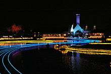
- Nagashima Spa Land - One of the largest amusement parks in Japan, located in Kuwana.
- Mikimoto Pearl Island - Museum in Toba that is dedicated to Kōkichi Mikimoto, inventor of pearl cultivation.
- The Wedded Rocks of Okitama Shrine in Futami (now part of the city of Ise)
- Suzuka Circuit - Japan's most famous motor racetrack.
- Saikū - Site of Heian Imperial residence, with modern museum and reconstructed Heian building.
- A large Sonic the Hedgehog statue can be found near Kanonji temple which has been the topic of discussion amongst gaming publications
Notable citizens
- Daikokuya Kōdayū, a Japanese castaway who spent eleven years in Russia
- Hakaru Hashimoto, medical scientist
- Mikimoto Kōkichi, founder of the cultured pearl industry
- Matsuo Bashō, the most famous poet of the Edo period, renowned for his haiku
- Mitsui Takatoshi, founder of the Mitsui Group
- Norinaga Motoori, a Japanese scholar of Kokugaku during the Edo period
- Ranpo Edogawa, famous mystery novelist
- Yukio Ozaki, a politician said to be the father of Japan's constitutional government
- Keiichi Yabu, relief pitcher for the San Francisco Giants
- Die (musician), guitarist from Dir en grey
- Hiroshi Okuda, Chairman of the Toyota Motor Corporation, chairman of the Japan Business Federation
- Hiroyuki Ito, a video game designer working for Square Enix
- Yasujirō Ozu, famous filmmaker
- Norinaga Motoori, scholar of Kokugaku during the Edo period
- Mizuki Noguchi, the gold medalist in the women's marathon event in the 2004 Summer Olympics
- Miwa Asao, beach volleyball player
- Ken Hirai, Japanese R&B and pop singer
- Katsuya Okada, former Foreign Minister, and DPJ Secretary General
- Kana Nishino, singer
- Jun Maeda, a Japanese writer and co-founder of the software company Key
- Aoi, guitarist of The GazettE
- Daisuke Kishio, voice actor
- Kenta Nishimoto, professional badminton player
- Mashiho Takata, a member of Korean-Pop boy group Treasure 13 and Magnum (unit)
Famous products
- Akafuku, a sweet made with mochi and sweet red bean paste
- Spiny lobster, known as Ise ebi (伊勢えび), named after the old province
- Matsusaka beef
Government and politics
The prefectural government was briefly moved to Yokkaichi Town in Mie District in 1872 (hence the name Mie), but the capital moved back to Anotsu, Anō District (present-day Tsu City) in 1873[9] and has remained there since. Ignoring small changes through cross-prefectural municipal mergers, neighbourhood transfers and coastline variations, Mie reached its present borders in 1876 when it absorbed Watarai Prefecture. After the modern reactivation of districts in 1878/79, Mie consisted of 21 districts (merged down to 15 in the 1890s).[10] The first prefectural assembly was elected in March 1879 and convened in April.[11] In the introduction of modern cities, towns and villages in 1889, Anotsu became district-independent as Tsu City and the districts were subdivided into 18 towns and 317 villages (see the List of mergers in Mie Prefecture for changes since then).
As in all prefectures except Okinawa, the governor of Mie is directly elected since 1947. The prefectural assembly has 51 members. Both prefectural elections in Mie are currently held as part of unified local elections. In the last round in 2019, governor Eikei Suzuki easily won a third term with broad support from LDP, Shinsei Mie (see below) and Kōmeitō, against only one, JCP-supported challenger;[12] Suzuki was originally elected narrowly in 2011 as centre-right candidate against centre-left supported Naohisa Matsuda, former mayor of Tsu City. In the Mie assembly, the LDP is strongest party;[13] but it is distributed across several parliamentary groups, and the strongest group is Shisei Mie (新政みえ; "Renewal Mie") around members of several local parties of former Democrats.[14]
In the National Diet, Mie is represented by four directly elected members of the House of Representatives and two (one per class) in the House of Councillors. After the national elections of 2016, 2017 and 2019, Mie's directly elected delegation was evenly split between Liberal Democrats (HR district #1: Norihisa Tamura, #4: Noriyo Mitsuya, HC 2019–25 class: Yūmi Yoshikawa) and ex-Democrats (HR #2: Masaharu Nakagawa, #3: Katsuya Okada, HC 2016–22 class: Hirokazu Shiba) in both houses of the Diet.
Notes
- Nussbaum, Louis-Frédéric. (2005). "Mie prefecture" in Japan Encyclopedia, p. 628, p. 628, at Google Books; "Kansai" in Japan Encyclopedia, p. 477, p. 477, at Google Books
- Nussbaum, "Tsu" in Japan Encyclopedia, p. 995, p. 995, at Google Books
- Nussbaum, "Provinces and prefectures" in Japan Encyclopedia, p. 780, p. 780, at Google Books
- Mie Prefecture homepage: Mie's Geography and Climate (pdf)
- 自然公園都道府県別面積総括 [General overview of area figures for Natural Parks by prefecture] (PDF) (in Japanese). Ministry of the Environment. Retrieved 21 July 2019.
- "Azuma Foods Co., Ltd.|Company Profile". Azumafoods.co.jp. Retrieved 2012-07-13.
- Hamlin, Suzanne (13 August 1997). "From Japan, A Big Wave Of Seaweed". The New York Times.
- Mie Prefecture Homepage: Key Statistics
- Prefectural government: 三重県庁舎(津市下部田) ("Mie prefectural government building (Tsu City, Lower Heta)"), retrieved June 24, 2020.
- Map of Mie's districts in January 1889, i.e. before the introduction of cities, Map of Mie's two cities and 15 districts in 1900
- Prefectural assembly: history/chronology since 1878 (Japanese), retrieved June 24, 2020.
- NHKSenkyoWeb: 2019 unified election results/prefectural governors/Mie, retrieved June 24, 2020.
- NHKSenkyoWeb: 2019 unified election results/prefectural assemblies/Mie [by nomination in that election, not by party membership, let alone parliamentary group membership, or affiliations at any previous or later point in time] (Japanese), retrieved June 24, 2020.
- Prefectural assembly: Members by parliamentary group (Japanese), retrieved June 24, 2020.
References
- Nussbaum, Louis-Frédéric and Käthe Roth. (2005). Japan encyclopedia. Cambridge: Harvard University Press. ISBN 978-0-674-01753-5; OCLC 58053128
External links
| Wikimedia Commons has media related to Mie prefecture. |
- Mie Prefecture official homepage
- Kanko Mie tourist information
- Outdoor Japan - Section Mie
- Mie International Exchange Foundation
Tsu (capital) | ||
| Special city |
| |
| Cities | ||
| Districts | ||
| Authority control |
|
|---|