Kumano, Mie
Kumano (熊野市, Kumano-shi) is a city located in Mie Prefecture, Japan.
Kumano 熊野市 | |
|---|---|
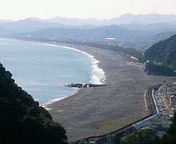 Shichirimihama Beach, Kumano | |
 Flag  Seal | |
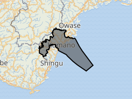
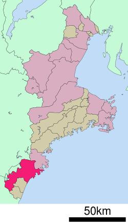
Location of Kumano in Mie Prefecture | |
 | |
 Kumano | |
| Coordinates: 33°53′19.1″N 136°6′0.8″E | |
| Country | Japan |
| Region | Kansai |
| Prefecture | Mie |
| Government | |
| • Mayor | Kanji Kawakami |
| Area | |
| • Total | 373.35 km2 (144.15 sq mi) |
| Population (August 2015) | |
| • Total | 17,727 |
| • Density | 47.5/km2 (123/sq mi) |
| Time zone | UTC+9 (Japan Standard Time) |
| Symbols | |
| • Tree | Cryptomeria |
| • Flower | Sasayuri (Lilium japonicum) |
| • Bird | Japanese bush-warbler |
| Phone number | 0597-89-4111 |
| Address | 796 Idochō, Kumano-shi, Mie-ken 519-4392 |
| Website | www |
As of August 2015, the city had an estimated population of 17,727 and a population density of 47.4 persons per km2. The total area was 373.35 square kilometres (144.15 sq mi).
Geography
Kumano is located near the southern tip of the Kii Peninsula, in southern Mie Prefecture, facing the Pacific Ocean. Parts of the city are within the limits of the Yoshino-Kumano National Park.
Neighboring municipalities
- Mie Prefecture
- Wakayama Prefecture
- Nara Prefecture
History
The city of Kumano was established on November 3, 1954 by the merger of the town of Kinomoto with the surrounding villages of Isato, Kamikawa, Arii, Atashika, Arasaki and Tomari (all from Minamimuro District).
On November 15, 2005, the town of Kiwa (also from Minamimuro District) was also merged into Kumano.
Economy
The economy of Kumano is centered on commercial fishing, forestry and horticulture (oranges).
Education
Kumano has nine elementary schools, seven middle schools and one high school, along with one special education school.
Transportation
Railway
Local attractions
A portion of the Sacred Sites and Pilgrimage Routes in the Kii Mountain Range, a UNESCO World Heritage Site is located within Kumano.
Climate
| Climate data for Kumano-Shingu (2002 - 2010) | |||||||||||||
|---|---|---|---|---|---|---|---|---|---|---|---|---|---|
| Month | Jan | Feb | Mar | Apr | May | Jun | Jul | Aug | Sep | Oct | Nov | Dec | Year |
| Daily mean °C (°F) | 6.7 (44.1) |
8.0 (46.4) |
10.4 (50.7) |
15.1 (59.2) |
18.7 (65.7) |
22.0 (71.6) |
25.6 (78.1) |
26.6 (79.9) |
24.3 (75.7) |
19.2 (66.6) |
14.0 (57.2) |
9.2 (48.6) |
16.7 (62.0) |
| Average low °C (°F) | 2.6 (36.7) |
3.7 (38.7) |
5.7 (42.3) |
10.6 (51.1) |
14.8 (58.6) |
18.7 (65.7) |
22.5 (72.5) |
23.3 (73.9) |
21.2 (70.2) |
15.9 (60.6) |
10.3 (50.5) |
5.3 (41.5) |
12.9 (55.2) |
| Average precipitation mm (inches) | 108.6 (4.28) |
114.1 (4.49) |
231.1 (9.10) |
241.8 (9.52) |
295.4 (11.63) |
308.6 (12.15) |
352.9 (13.89) |
298.3 (11.74) |
404.2 (15.91) |
330.2 (13.00) |
183.4 (7.22) |
113.7 (4.48) |
2,982.3 (117.41) |
| Mean monthly sunshine hours | 164.7 | 153.8 | 184.6 | 180.4 | 166.3 | 131.5 | 154.5 | 183.6 | 144.9 | 126.1 | 144.5 | 165.9 | 1,900.8 |
| Source: Japan Meteorological Agency (JMA)[1] | |||||||||||||
Sister city relations
Notable people
- Shigeru Kasamatsu – Olympic gymnast
References
- "気象庁|過去の気象データ検索". Retrieved 2014-12-26.
- "International Exchange". List of Affiliation Partners within Prefectures. Council of Local Authorities for International Relations (CLAIR). Archived from the original on 5 February 2016. Retrieved 21 November 2015.
External links


- Official website (in Japanese)
Tsu (capital) | ||
| Special city |
| |
| Cities | ||
| Districts | ||
| Authority control |
|
|---|