Memorial Drive (Cambridge)
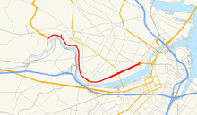
Memorial Drive (colloquially referred to as Mem Drive) is a 3.9-mile (6.3 km) parkway along the north bank of the Charles River in Cambridge, Massachusetts. It runs parallel to two major Boston parkways - Soldiers Field Road and Storrow Drive - which lie on the south bank of the river. The western terminus is in West Cambridge at Greenough Boulevard and Fresh Pond Parkway. The eastern terminus is at Main Street and the Longfellow Bridge near Kendall Square. Memorial Drive is designated as U.S. Route 3 for most of its length, except the easternmost 0.7 miles (1.1 km) which are designated as Massachusetts Route 3 (US 3 and Route 3 connect end-to-end and are treated as one continuous route by the state). Route 2 is cosigned with US 3 on Memorial Drive between the western terminus and the Boston University Bridge.
   | |
|---|---|
| Charles River Road | |
 | |
| Maintained by | Massachusetts DCR |
| Length | 3.9 mi[1][2][3] (6.3 km) |
| Coordinates | 42°21′47″N 71°06′58″W |
| West end | |
| Major junctions | |
| East end | |
| Construction | |
| Inauguration | 1923 |
.jpg)
History
Formerly known as Charles River Road, the road was officially renamed "Memorial Drive" in 1923,[4] when Charles River Park was taken over by the Metropolitan District Commission. It is named in honor of those who died in World War I.[5]
In 2003 a two-mile section of Memorial Drive was reconstructed as part of the DCR's Historic Parkways Initiative.
Route description
Memorial Drive begins in West Cambridge, signed as US 3 south and Route 2 east, at a three-way junction (a former rotary) with Greenough Boulevard (which continues roughly westward along the river and provides access to the Eliot Bridge) and Fresh Pond Parkway, which runs roughly north and carries the US 3 / Route 2 concurrency westward. It proceeds generally southward, following the sinuous curves of the river, from which it is separated by a strip of parkland that varies considerably in its width. In the western stretch it has four undivided lanes, two in each direction (although parking is permitted on the outer westbound lane for a short section west of JFK Street). After crossing River Street it turns more eastward at the Magazine Street beach, with Route 2 diverging southward at a rotary-like interchange with overpass to cross the BU Bridge into Boston. Soon afterward the road is lined on the north by the buildings of the main Massachusetts Institute of Technology (MIT) campus. A grassy median is introduced along this stretch, and the road crosses under Massachusetts Avenue (Route 2A), with ramps providing limited interchange options. Heading eastbound, the designation changes from US 3 to Route 3 at this interchange (and vice versa westbound). The grassy median continues to divide the road until its end near Kendall Square at the Longfellow Bridge. Edwin H. Land Boulevard splits off and continues north towards O'Brien Highway (Route 28) and Interstate 93. Route 3 turns east onto the Longfellow Bridge and also crosses into Boston. The median, where present, has occasional opportunities for reversing direction.
Memorial Drive, like the parkways along the opposite (Boston) side of the river, is maintained by the Massachusetts Department of Conservation and Recreation (the successor to the Metropolitan District Commission). In keeping with the recreational mission, the section of Memorial Drive from Western Avenue to the split by Mount Auburn Hospital, at Gerry's Landing Road, is closed to motor vehicles on Sundays in the summer to allow for pedestrian and non-motorized users. The closure is in effect from 11 am to 7 pm starting the last Sunday of April until the second Sunday of November.[6]
A median near Massachusetts Avenue requires executing a so-called Michigan left for certain turns.
Major intersections
The entire route is in Cambridge, Middlesex County.
| Location | mi[3] | km | Destinations | Notes | |
|---|---|---|---|---|---|
| West Cambridge | 0.0 | 0.0 | Western terminus; US 3 / Route 2 continue west on Fresh Pond Parkway | ||
| Riverside | 0.7 | 1.1 | John F. Kennedy Street – Harvard Square | ||
| 1.4 | 2.3 | To Western Avenue Bridge | |||
| Cambridgeport | 2.2 | 3.5 | Eastern end of Route 2 concurrency; to Boston University Bridge | ||
| MIT Campus | 3.2 | 5.1 | Interchange with Michigan lefts; southern terminus of US 3; northern terminus of Route 3 | ||
| 3.7 | 6.0 | Wadsworth Street – Kendall Square | |||
| 3.8 | 6.1 | Edwin H. Land Boulevard east – Kendall Square | Interchange | ||
| 3.9 | 6.3 | Eastern terminus; Route 3 continues on Longfellow Bridge | |||
1.000 mi = 1.609 km; 1.000 km = 0.621 mi
| |||||
See also
- Soldiers Field Road and Storrow Drive, on the Boston side of the river
- Charles River Bike Path
- List of crossings of the Charles River
- Charles River Reservation#Riverbend Park
- Charles River Reservation
References
- Michael Trust (2010-08-30). "Executive Office of Transportation - Office of Transportation Planning Roads - June 2008". Mass.gov. Retrieved 2011-08-31.
- Distance corrected per Google Earth, 2013-05-12, to exclude Gerry's Landing Road leg (connection to Fresh Pond Parkway) erroneously included in 2008 Trust report distance measurement.
- Google (November 24, 2014). "Memorial Drive" (Map). Google Maps. Google. Retrieved November 24, 2014.
- 1923 per bottom left of page 2 of the Cambridge Chronicle (dedication June 10, 1923:) The Cambridge Historical Commission gives 1922 as year of renaming.
- Cambridge Street Names Archived 2012-09-29 at the Wayback Machine, compiled by the Cambridge Historical Commission, updated June 30, 2009
- "Memorial Drive Closed Sundays". Cambridgema.gov. Archived from the original on 2011-08-20. Retrieved 2011-08-31.
