Castle Island (Massachusetts)
Castle Island is a peninsula in South Boston on the shore of Boston Harbor. In 1928, Castle Island was connected to the mainland by a narrow strip of land and is thus no longer an island.[3] It has been the site of a fortification since 1634,[3] and is currently a 22-acre (8.9 ha) recreation site and the location of Fort Independence.[2]
| Castle Island | |
|---|---|
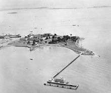
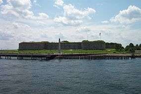 Fort Independence at Castle Island | |
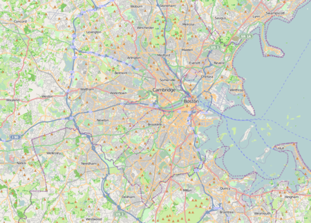 Location in Massachusetts 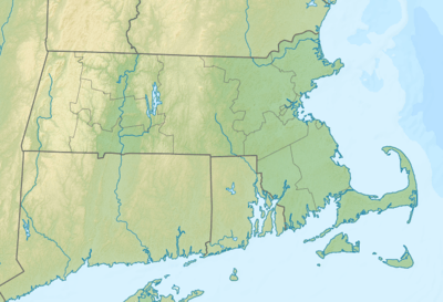 Castle Island (Massachusetts) (Massachusetts)  Castle Island (Massachusetts) (the United States) | |
| Location | Boston, Suffolk, Massachusetts, United States |
| Coordinates | 42°20′15″N 71°00′38″W[1] |
| Area | 22 acres (8.9 ha)[2] |
| Elevation | 33 ft (10 m)[1] |
| Established | Unspecified |
| Operator | Massachusetts Department of Conservation and Recreation |
| Website | Castle Island etc. |

History
- 1632: A battery was constructed at Fort Hill, the southernmost portion of the Boston peninsula as an advance line of defense in case of attack.
- 1634: Now an established community, Boston sought defenses farther out in the harbor, on one of the numerous islands which protected the port; shipping being the only means of receiving supplies and communications from England. Hull was the first site inspected but the cold sea breeze proved too much for Governor Winthrop and his counselors and this idea was abandoned. In July of this year twenty men, including Governor Thomas Dudley and his council, visited Castle Island and decided it would be perfect site for a fortress. Each man present subscribed 5 pounds for the fortification and elected Deputy Governor Roger Ludlow and Captain John Mason of Dorchester, to supervise construction. After two platforms and a small earthwork were constructed on the northeast side of the island, the General Court resolved that the fort at Castle Island be fully perfected, before any other fortification was begun.
- 1635: Three cannons, one of which belonged to Deputy Governor Bilingham, were carried down on lighters and installed at the Castle and the garrison, made up of two men weekly from each of the six towns to be paid from the treasury of the colony, fired these at incoming vessels until the ship recognized the fortification by raising her flag. Thomas Beecher (ancestor of Henry Ward Beecher) who had come over as master of the "Talbot" was one of the Castle officers at this time. Captain Nicholas Simpkins was the first commander (followed by Lt Edward Gibbons). Roger Clapp served for several decades as an officer at Castle Island.
- 1775: Prince Hall and fourteen other men of African descent became freemasons on March 6, 1775 on the island. They were initiated in a British Army Lodge, No. 441 of the Irish Registry by J. E. Batt, Worshipful Master, on what was then still called Castle William Island.
First named Castle William by the English, who were fighting the French for control over North America. One of the more famous figures to be imprisoned at the Fort was privateer Pierre Maisonnat dit Baptiste (1702–06).
The fort was renamed Fort Independence in 1797 and is one of the oldest fortified sites in British North America. In the late 18th-century it served as the first state prison in Massachusetts.[4] The present structure, built between 1833 and 1851, is the eighth generation of forts. It is listed on the National Register of Historic Places.
During the Siege of Boston at the start of the American Revolution "Castle William" served as the main base of military operations for the British. The leaders of the Massachusetts royal administration took refuge there with their families, as did some prominent loyalists or "tories." Major Pelham Winslow of the prominent loyalist town of Marshfield, Massachusetts was the Commander of Castle William for a time during the Revolution. After the March 17, 1776 British Evacuation of Boston, Castle William was destroyed a few days later (March 20, 1776).[5]
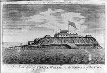 Castle William, as it appeared before its destruction in 1776
.jpg) 1888 map of Boston Harbor showing Castle Island as an island
1888 map of Boston Harbor showing Castle Island as an island
Long recognized for its strategic location, a new fort on Castle Island built by the war department beginning in 1801[3] helped protect Boston from British attack during the War of 1812. The island is also the site of a monument to Donald McKay, the builder of the famous clipper ships Flying Cloud and Sovereign of the Seas. The monument faces across Boston Harbor towards East Boston, where McKay built his ships.
Castle Island was originally some distance offshore, but land reclamation for expansion of port facilities has extended the mainland towards it, and it is now connected to the mainland by pedestrian and vehicle causeways. Today it is operated as a state park by the Massachusetts Department of Conservation and Recreation and is open to tours in the summer.
Local lore has it that an unpopular officer was walled up in the fort's dungeon following a duel in which he killed a more popular man. Edgar Allan Poe learned of the legend while serving on Castle Island in the Army, and his short story "The Cask of Amontillado" is said to be based on it.[6]
During World War II the U.S. Navy used the site for a ship degaussing station.
As a visitor attraction
Castle Island is open to the public year-round. Interpretive programs are conducted by the Castle Island Association in conjunction with the Massachusetts Department of Conservation and Recreation.[2][7] Attractions include a playground, beach and swimming access, and restaurant Sullivan's.[8] Tours of Fort Independence are conducted by The Castle Island Association on a season schedule.
Places named after Castle (William) Island
- Castle William Lodge #11, Prince Hall Grand Lodge, Boston, Massachusetts
- Castle William Chapter #4, Prince Hall Grand Chapter, Order of the Eastern Stars, Boston, Massachusetts
- Castle Island Brewing Company, 31 Astor Avenue, Norwood, Massachusetts
See also
Further reading
- "Punishment at Hard Labor: Stephen Burroughs and the Castle Island Prison, 1785–1798." The New England Quarterly, Vol. 57, No. 2 (June 1984), pp. 249–254.
References
- "Castle Island". Geographic Names Information System. United States Geological Survey.
- "Castle Island, Pleasure Bay, M Street Beach and Carson Beach". MassParks. Executive Office of Energy and Environmental Affairs. Retrieved August 22, 2013.
- "Fort Independence". Object of the Month. Massachusetts History Society. Retrieved February 2, 2014.
- State of Massachusetts, Acts and Resolves, 1784–1785 (Boston, 1886), 163.
- Robertson, Archibald. "His Diaries and Sketches in America" (New York: New York Public Library & Arno Press Inc, 1971 reprint edition). (Mar 18–20, 1776) 80–81 (see plate 25 for a sketch of the Castle’s destruction, appearing after 242).
- "Treasure Islands". UMass Magazine Online. University of Massachusetts Amherst. Spring 2004. Archived from the original on February 3, 2006. Retrieved February 2, 2014.
- "Fort Independence, Castle Island, South Boston". Castle Island Association. Retrieved February 2, 2014.
- http://www.sullivanscastleisland.com
External links
| Wikimedia Commons has media related to Castle Island. |
- Castle Island, Pleasure Bay, M Street Beach and Carson Beach Department of Conservation and Recreation
- Castle Island Map Department of Conservation and Recreation
| |||||||||||||||||
| |||||||||||||||||
| |||||||||||||||||
| |||||||||||||||||
| |||||||||||||||||
| |||||||||||||||||
| |||||||||||||||||
| |||||||||||||||||