Maurepas, Yvelines
Maurepas is a commune in the Yvelines department in the Île-de-France region in north-central France. It is located in the western suburbs of Paris 31.2 km (19.4 mi) from the center.
Maurepas | |
|---|---|
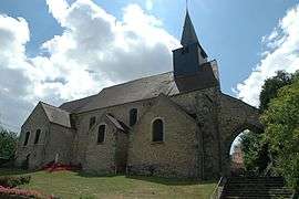 The church of Saint-Sauveur, in Maurepas | |
.svg.png) Coat of arms | |
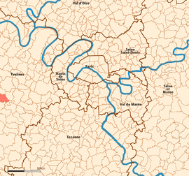 Location (in red) within Paris inner and outer suburbs | |
Location of Maurepas 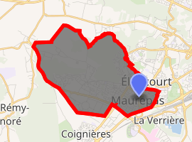
| |
 Maurepas Location (in red) within Paris inner and outer suburbs  Maurepas Maurepas (Île-de-France (region)) | |
| Coordinates: 48°46′N 1°57′E | |
| Country | France |
| Region | Île-de-France |
| Department | Yvelines |
| Arrondissement | Rambouillet |
| Canton | Maurepas |
| Intercommunality | Saint-Quentin-en-Yvelines |
| Government | |
| • Mayor (2014) | Grégory Garestier |
| Area 1 | 8.32 km2 (3.21 sq mi) |
| Population (2017-01-01)[1] | 18,281 |
| • Density | 2,200/km2 (5,700/sq mi) |
| Time zone | UTC+01:00 (CET) |
| • Summer (DST) | UTC+02:00 (CEST) |
| INSEE/Postal code | 78383 /78310 |
| Elevation | 87–178 m (285–584 ft) |
| 1 French Land Register data, which excludes lakes, ponds, glaciers > 1 km2 (0.386 sq mi or 247 acres) and river estuaries. | |
History
Most ancient buildings are the ruins of the donjon, built in the 11th century and destroyed in 1425.
There is also near St Sauveur's church, dating from the 15th century.
In 768, the French king Pepin the Short offered the village of Maurepas (formerly spelled Malrepast) and its wooden keep to the Abbey of Saint-Denis. Facing the Normans' invasions, they left the domain to the Lords of Chevreuse. The castle and village were given to the family of Malrepast, a vassal of the Lords of Chevreuse, which gave its name to the village.
In 1432, during the Hundred Years' War, the English conquered the village and destroyed the keep.
After the war, the domain of Maurepas returned to the family of Chevreuse, but the castle remained a ruin.
Jean-Frédéric Phélypeaux from the Phélypeaux family, was Count of Maurepas. He was living in the next city of Jouars-Pontchartrain in the Château de Pontchartrain.
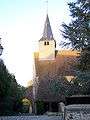 Entrance of church Saint-Sauveur.
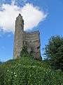 The ruins of the donjon.
People
who lived in Maurepas
- Erich von Stroheim - (1885 - 1957), Austrian-American actor, film director, producer born in Vienna, Austria, died at his home in Maurepas from cancer.
Transportation
Maurepas is served by no station of the Paris Métro, RER, or suburban rail network. The closest station to Maurepas is La Verrière station on the Transilien La Défense and Transilien Paris – Montparnasse suburban rail lines. This station is located in the neighboring commune of La Verrière, 0.7 km (0.43 mi) from the town center of Maurepas.
Demography
| |||||||||||||||||||||||||||
| |||||||||||||||||||||||||||
| |||||||||||||||||||||||||||
| |||||||||||||||||||||||||||
Education
Junior high schools:[2]
- Collège Alexandre Dumas
- Collège Louis Pergaud
- Collège de la Mare aux Saules in nearby Coignières
Senior high schools/sixth-form colleges:[2]
- Lycée des 7 Mares
- Lycée Dumont d'Urville
Twin towns
It is twinned with Waterlooville in Hampshire, and Tirat Carmel in Haifa district, Israel.
See also
References
- "Populations légales 2017". INSEE. Retrieved 6 January 2020.
- "Annuaire des écoles publiques." Maurepas. Retrieved on September 3, 2016.
External links
| Wikimedia Commons has media related to Maurepas (Yvelines). |
- Official website (in French)
| Authority control |
|
|---|