Autouillet
Autouillet (French pronunciation: [otuje]) is a commune in the Yvelines department in north-central France.
Autouillet | |
|---|---|
 The town hall in Autouillet | |
.svg.png) Coat of arms | |
Location of Autouillet 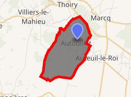
| |
 Autouillet  Autouillet | |
| Coordinates: 48°51′01″N 1°48′17″E | |
| Country | France |
| Region | Île-de-France |
| Department | Yvelines |
| Arrondissement | Rambouillet |
| Canton | Aubergenville |
| Intercommunality | CC Cœur Yvelines |
| Government | |
| • Mayor (2014-2020) | Françoise Lenard |
| Area 1 | 4.94 km2 (1.91 sq mi) |
| Population (2017-01-01)[1] | 509 |
| • Density | 100/km2 (270/sq mi) |
| Time zone | UTC+01:00 (CET) |
| • Summer (DST) | UTC+02:00 (CEST) |
| INSEE/Postal code | 78036 /78770 |
| Elevation | 88–171 m (289–561 ft) (avg. 110 m or 360 ft) |
| 1 French Land Register data, which excludes lakes, ponds, glaciers > 1 km2 (0.386 sq mi or 247 acres) and river estuaries. | |
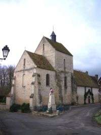
The church
Population
| Historical population | ||
|---|---|---|
| Year | Pop. | ±% |
| 1793 | 272 | — |
| 1800 | 261 | −4.0% |
| 1806 | 259 | −0.8% |
| 1821 | 274 | +5.8% |
| 1831 | 275 | +0.4% |
| 1836 | 278 | +1.1% |
| 1841 | 247 | −11.2% |
| 1846 | 247 | +0.0% |
| 1851 | 250 | +1.2% |
| 1856 | 238 | −4.8% |
| 1861 | 220 | −7.6% |
| 1866 | 231 | +5.0% |
| 1872 | 218 | −5.6% |
| 1876 | 231 | +6.0% |
| 1881 | 231 | +0.0% |
| 1886 | 224 | −3.0% |
| 1891 | 223 | −0.4% |
| 1896 | 223 | +0.0% |
| 1901 | 228 | +2.2% |
| 1906 | 229 | +0.4% |
| 1911 | 200 | −12.7% |
| 1921 | 176 | −12.0% |
| 1926 | 193 | +9.7% |
| 1931 | 167 | −13.5% |
| 1936 | 171 | +2.4% |
| 1946 | 183 | +7.0% |
| 1954 | 165 | −9.8% |
| 1962 | 160 | −3.0% |
| 1968 | 149 | −6.9% |
| 1975 | 189 | +26.8% |
| 1982 | 270 | +42.9% |
| 1990 | 251 | −7.0% |
| 1999 | 349 | +39.0% |
| 2008 | 463 | +32.7% |
| 2014 | 470 | +1.5% |
See also
References
- "Populations légales 2017". INSEE. Retrieved 6 January 2020.
| Wikimedia Commons has media related to Autouillet. |
| Authority control |
|
|---|
This article is issued from Wikipedia. The text is licensed under Creative Commons - Attribution - Sharealike. Additional terms may apply for the media files.