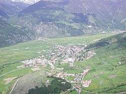
Mals
Mals (German pronunciation: [mals]; Italian: Malles Venosta [ˈmallez veˈnɔsta]) is a comune (municipality) in South Tyrol in northern Italy, located about 70 kilometres (43 mi) northwest of Bolzano, on the border with Switzerland and Austria.
Mals | |
|---|---|
| Gemeinde Mals Comune di Malles Venosta | |
 | |
 Coat of arms | |
Location of Mals 
| |
 Mals Location of Mals in Italy 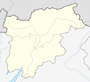 Mals Mals (Trentino-Alto Adige/Südtirol) | |
| Coordinates: 46°42′N 10°33′E | |
| Country | Italy |
| Region | Trentino-Alto Adige/Südtirol |
| Province | South Tyrol (BZ) |
| Frazioni | Burgeis (Burgusio), Laatsch (Laudes), Matsch (Mazia), Planeil (Planol), Plawenn (Piavenna), Schleis (Clusio), Schlinig (Slingia), Tartsch (Tarces), Ulten-Alsack (Alsago-Ultimo) |
| Government | |
| • Mayor | Ulrich Veith |
| Area | |
| • Total | 246.7 km2 (95.3 sq mi) |
| Elevation | 1,051 m (3,448 ft) |
| Population (Nov. 2010)[2] | |
| • Total | 5,092 |
| • Density | 21/km2 (53/sq mi) |
| Demonym(s) | German:Malser Italian: mallesi |
| Time zone | UTC+1 (CET) |
| • Summer (DST) | UTC+2 (CEST) |
| Postal code | 39024 |
| Dialing code | 0473 |
| Website | Official website |
History
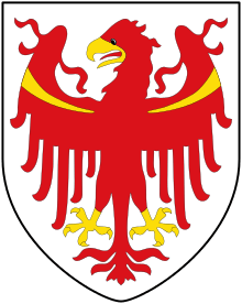
Coat-of-arms
The emblem is party per fess: the upper of gules a fess argent, at the bottom or three gules circles arranged in a triangle upside-down. It is the combination of coats of arms of the House of Austria and Medici. The emblem was adopted in 1928.[3]
Geography
As of 30 November 2010, it had a population of 5,092 and an area of 246.7 square kilometres (95.3 sq mi).[4]
Mals borders the following municipalities: Graun im Vinschgau, Glurns, Laas, Scuol (Switzerland), Schnals, Sent (Switzerland), Schlanders, Schluderns, Sölden (Austria), and Taufers im Münstertal.
Frazioni
The municipality of Mals contains the frazioni (subdivisions, mainly villages and hamlets) Burgeis (Burgusio), Laatsch (Laudes), Matsch (Mazia), Planeil (Planol), Plawenn (Piavenna), Schleis (Clusio), Schlinig (Slingia), Tartsch (Tarces), and Ulten-Alsack (Alsago-Ultimo).
Climate and Temperature
| Climate data for Mals ITA, 2009–2018 normals | |||||||||||||
|---|---|---|---|---|---|---|---|---|---|---|---|---|---|
| Month | Jan | Feb | Mar | Apr | May | Jun | Jul | Aug | Sep | Oct | Nov | Dec | Year |
| Record high °C (°F) | 3 (37) |
3 (37) |
7 (45) |
13 (55) |
19 (66) |
22 (72) |
24 (75) |
24 (75) |
20 (68) |
17 (63) |
12 (54) |
4 (39) |
24 (75) |
| Mean maximum °C (°F) | 0.8 (33.4) |
1.2 (34.2) |
3.0 (37.4) |
7.6 (45.7) |
14.6 (58.3) |
20.4 (68.7) |
21.2 (70.2) |
21.8 (71.2) |
16.9 (62.4) |
12.6 (54.7) |
5.9 (42.6) |
1.9 (35.4) |
22.6 (72.7) |
| Average high °C (°F) | −4.0 (24.8) |
−3.9 (25.0) |
−0.6 (30.9) |
2.6 (36.7) |
7.3 (45.1) |
12.9 (55.2) |
16.0 (60.8) |
15.9 (60.6) |
11.7 (53.1) |
6.2 (43.2) |
0.4 (32.7) |
−3.3 (26.1) |
5.1 (41.2) |
| Daily mean °C (°F) | −8.7 (16.3) |
−8.8 (16.2) |
−5.4 (22.3) |
−1.8 (28.8) |
2.8 (37.0) |
7.9 (46.2) |
10.5 (50.9) |
10.5 (50.9) |
6.8 (44.2) |
2.0 (35.6) |
−3.2 (26.2) |
−7.3 (18.9) |
0.4 (32.7) |
| Average low °C (°F) | −13.3 (8.1) |
−13.7 (7.3) |
−10.2 (13.6) |
−6.1 (21.0) |
−1.8 (28.8) |
2.8 (37.0) |
4.9 (40.8) |
5.1 (41.2) |
1.9 (35.4) |
−2.3 (27.9) |
−6.7 (19.9) |
−11.2 (11.8) |
−4.2 (24.4) |
| Mean minimum °C (°F) | −24.4 (−11.9) |
−25.3 (−13.5) |
−20.6 (−5.1) |
−15.8 (3.6) |
−10.1 (13.8) |
−4.1 (24.6) |
0.0 (32.0) |
0.0 (32.0) |
−2.8 (27.0) |
−12.0 (10.4) |
−17.1 (1.2) |
−20.9 (−5.6) |
−27.5 (−17.5) |
| Record low °C (°F) | −32.0 (−25.6) |
−29.0 (−20.2) |
−27.0 (−16.6) |
−22.0 (−7.6) |
−18.0 (−0.4) |
−11.0 (12.2) |
−1.0 (30.2) |
−2.0 (28.4) |
−6.0 (21.2) |
−18.0 (−0.4) |
−34 (−29) |
−26 (−15) |
−34 (−29) |
| Average rainfall mm (inches) | 16.37 (0.64) |
18.50 (0.73) |
18.43 (0.73) |
25.90 (1.02) |
30.85 (1.21) |
32.41 (1.28) |
29.00 (1.14) |
32.83 (1.29) |
35.02 (1.38) |
53.43 (2.10) |
31.29 (1.23) |
21.66 (0.85) |
345.67 (13.61) |
| Average snowfall cm (inches) | 13.5 (5.3) |
15.5 (6.1) |
14.5 (5.7) |
20.1 (7.9) |
19.8 (7.8) |
8.3 (3.3) |
1.3 (0.5) |
3.2 (1.3) |
14.0 (5.5) |
31.2 (12.3) |
23.4 (9.2) |
16.4 (6.5) |
181.3 (71.4) |
| Average relative humidity (%) | 90.9 | 92.7 | 92.6 | 92.4 | 89.6 | 81.7 | 77.8 | 79.8 | 81.2 | 83.4 | 89.0 | 85.9 | 86.4 |
| Source: World Weather Online[5] | |||||||||||||
Mals has a cool, wet climate. Frost is common from October to May and is even recorded in the summer, although temperatures below -1C are rare from June to September. Most winter days fail to rise above freezing. Summer is generally mild, but most summers see temperatures rise above 20C on several days.
Transportation
The commune is the northern terminus of the train from Meran. The trip from Merano takes approximately 1 hour 15 minutes. Trains depart hourly. There is also local bus service between Mals and Schlanders.[6]
Notable people
- Johann Rufinatscha (1812–1893) an Austrian composer, theorist and music teacher
- Karl Plattner (1919–1986) painter.
- Gabriel Grüner (1963-1999) journalist for Stern magazine, shot by Yugoslav soldiers
Society
Linguistic distribution
According to the 2011 census, 96.92% of the population speak German, 3.00% Italian and 0.08% Ladin as first language.[7]
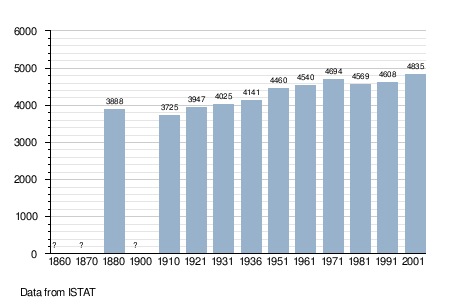
Demographic evolution
Gallery
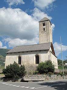 St. Benedict's Church in Mals
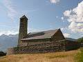 St. Veit am Bichl in Tartsch
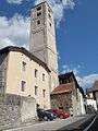 Tower of the old St. John's Church
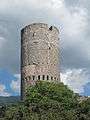 The tower Fröhlichsturm in Mals
References
- "Superficie di Comuni Province e Regioni italiane al 9 ottobre 2011". Istat. Retrieved 16 March 2019.
- "Popolazione Residente al 1° Gennaio 2018". Istat. Retrieved 16 March 2019.
- Heraldry of the World: Mals
- All demographics and other statistics: Italian statistical institute Istat.
- "Mals, Italy Weather Averages". World Weather Online. Retrieved March 4, 2019.
- "SII Timetables". SAD Trasporto Locale S.p.A. Retrieved 26 December 2016.
- "Volkszählung 2011/Censimento della popolazione 2011". astat info. Provincial Statistics Institute of the Autonomous Province of South Tyrol (38): 6–7. June 2012. Retrieved 2012-06-14.
External links
- Municipality of Mals Homepage (in German and Italian)
- General information about Mals, Tourism and Shopping (English)

| Authority control |
|
|---|