Graun im Vinschgau
Graun im Vinschgau (German pronunciation: [graʊ̯n im ˈfɪnʃgaʊ̯]; Italian: Curon Venosta [kuˈroɱ veˈnɔsta]; Romansh: La Carun) is a comune (municipality) in South Tyrol in northern Italy, located about 70 kilometres (43 mi) northwest of Bolzano, on the border with Austria and Switzerland.
Graun im Vinschgau La Carun | |
|---|---|
| Gemeinde Graun im Vinschgau Comune di Curon Venosta | |
 | |
 Coat of arms | |
Location of Graun im Vinschgau 
| |
 Graun im Vinschgau Location of Graun im Vinschgau in Italy 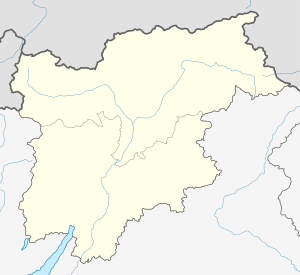 Graun im Vinschgau Graun im Vinschgau (Trentino-Alto Adige/Südtirol) | |
| Coordinates: 46°48′N 10°32′E | |
| Country | Italy |
| Region | Trentino-Alto Adige/Südtirol |
| Province | South Tyrol (BZ) |
| Frazioni | Langtaufers (Vallelunga), Reschen (Resia), St. Valentin (San Valentino alla Muta) |
| Government | |
| • Mayor | Heinrich Noggler |
| Area | |
| • Total | 210.5 km2 (81.3 sq mi) |
| Elevation | 1,520 m (4,990 ft) |
| Population (January 2011)[2] | |
| • Total | 2,447 |
| • Density | 12/km2 (30/sq mi) |
| Demonym(s) | German: Grauner Italian: curonesi |
| Time zone | UTC+1 (CET) |
| • Summer (DST) | UTC+2 (CEST) |
| Postal code | 39020 |
| Dialing code | 0473 |
| Website | Official website |
Geography
At 1 January 2011, it had a registered population of 2,447 and an area of 210.5 square kilometres (81.3 sq mi).[3]
The municipality of Graun im Vinschgau contains the subdivisions Langtaufers/Vallelunga, Reschen/Resia, Rojen/Roja and Sankt Valentin auf der Haide/San Valentino alla Muta.
Graun im Vinschgau borders the following municipalities: Mals, Kaunertal (Austria), Nauders (Austria), Pfunds (Austria), Sölden (Austria), Ramosch (Switzerland), Sent (Switzerland), and Tschlin (Switzerland).
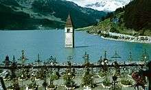
The village borders the Reschensee, massively deepened and extended when the valley was dammed in order to produce hydro-electricity. The original town can no longer be visited, having been abandoned and largely demolished by the time of the dam's completion in July 1950. Graun was rebuilt on the new shores. The ancient half-submerged bell-tower has become a landmark, and is the centrepiece of the commune's coat of arms.
History
In 15 BC the Celtic people then living in the upper Vinschgau valley found themselves incorporated into the Roman Empire following the construction of a commercial and military route crossing the Alps via what is now known as the Reschen Pass, the route then being called the "Via Claudia Augusta".
The transalpine route retained its importance through the medieval period, being variously called the "Upper Way" ("Oberer Weg"/"Via Superiore") or the "Swabia Road" ("Schwabenweg"/"Via di Svevia").
After 450 a wave of Christian missionaries arrived from Chur. By the time of the Black death (1348), from which most of the population of the time died, most of the Vinschgau Valley, including Graun, had been settled by German speakers; the exception being the side valley of Müstair, where the Romansh language survives to this day. German has remained the majority language in Graun since and as of 2011 German was the first language for more than 97% of its population.
Coat-of-arms
The escutcheon is party per fess, azure on the bottom and argent on the upper part, separated by a thin vert stripe. At the center is shown a gray bell tower, with three windows, and an azure point. The bell tower is that of the fourteenth century which emerges from the reservoir after the dam construction. The emblem was granted in 1967.[4]
Society
Linguistic distribution
According to the 2011 census, 97.34% of the population speak German and 2.66% Italian as first language, a ratio that had hardly moved since the 2001 census.[5]
Demographic evolution

Transportation
The municipality is served by public bus. Destinations include Mals to the south; and Nauders, Austria; and Martina, Switzerland to the north.
In popular culture
The supernatural drama television series Curon was primarily shot in the town and the surrounding locations.
References
- "Superficie di Comuni Province e Regioni italiane al 9 ottobre 2011". Istat. Retrieved 16 March 2019.
- "Popolazione Residente al 1° Gennaio 2018". Istat. Retrieved 16 March 2019.
- All demographics and other statistics: Italian statistical institute Istat.
- Heraldry of the World: Graun im Vinschgau
- "Volkszählung 2011/Censimento della popolazione 2011". astat info. Provincial Statistics Institute of the Autonomous Province of South Tyrol (38): 6–7. June 2012. Retrieved 2012-06-14.
External links
![]()
- (in German and Italian) Homepage of the municipality

| Authority control |
|
|---|