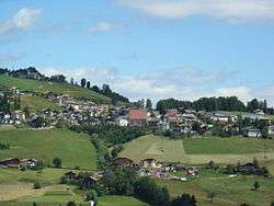
Deutschnofen
Deutschnofen (German pronunciation: [dɔɪ̯tʃn̩'oˑfn̩]; Italian: Nova Ponente [ˈnɔːva poˈnɛnte]) is a comune (municipality) in the province of South Tyrol in northern Italy, located about 30 kilometres (19 mi) southeast of the city of Bolzano.
Deutschnofen | |
|---|---|
| Gemeinde Deutschnofen Comune di Nova Ponente | |
 | |
Location of Deutschnofen 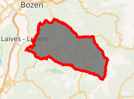
| |
 Deutschnofen Location of Deutschnofen in Italy 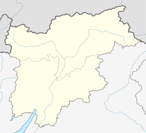 Deutschnofen Deutschnofen (Trentino-Alto Adige/Südtirol) | |
| Coordinates: 46°25′N 11°26′E | |
| Country | Italy |
| Region | Trentino-Alto Adige/Südtirol |
| Province | South Tyrol (BZ) |
| Frazioni | Petersberg (Monte San Pietro), Sankt Nikolaus/Eggen (San Nicolò d'Ega) |
| Government | |
| • Mayor | Bernhard Daum (SVP) |
| Area | |
| • Total | 112.0 km2 (43.2 sq mi) |
| Population (Nov. 2010)[2] | |
| • Total | 3,898 |
| • Density | 35/km2 (90/sq mi) |
| Demonyms | German: Deutschnofner Italian: di Nova Ponente |
| Time zone | UTC+1 (CET) |
| • Summer (DST) | UTC+2 (CEST) |
| Postal code | 39050 |
| Dialing code | 0471 |
| Website | Official website |
Geography
As of 30 November 2010, it had a population of 3,898 and an area of 112.0 square kilometres (43.2 sq mi).[3]
Deutschnofen borders the following municipalities: Aldein, Bolzano, Bronzolo, Karneid, Laives, Welschnofen, and municipalities of Predazzo, Tesero and Varena in Trentino.
Deutschnofen also holds the villages of Rauth (Novale) and Obereggen. There is a church and several cafes and hotels.
The A22 motorway is located 15 kilometres (9 mi) from the village. Deutschnofen shares 7 km of the frontier with Trentino.
Frazioni
The municipality of Deutschnofen contains the frazioni (subdivisions, mainly villages and hamlets) Petersberg (Italian: Monte San Pietro) and Sankt Nikolaus/Eggen (Italian: San Nicolò d'Ega).
Villages
Obereggen
Obereggen is a small tourist village belonging to the municipality of Deutschnofen. Located on the foot of the Latemar, Obereggen numbers 900 inhabitants. Another nearby mountain is the Schmieder (in the hamlet of Zapf).
There are at least three hotels in this borough, and a network of mountain bike and footpaths on Latemar side. There also are numerous cable-ways and ski lifts.
Sankt Florian
The very rural hamlet of Sankt Florian (Italian: San Floriano) is between the hamlet of Zapf and the centre of Obereggen. There are no hotels or shops, but the hamlet does feature guesthouses. There is a chapel (for the Saint Florian, this is the only chapel in Obereggen), and one paved road, as well as a number of unpaved paths.
History
Coat-of-arms
The coat of arms is party per fess of argent and gules crossed, from edge to edge, from a knotty sable branch. The color argent symbolizes the deposits of dolomite and the gules ones those of porphyry; the branch represents the woodiness of the municipality. The emblem was adopted in 1969.[4]
Society
Linguistic distribution
According to the 2011 census, 97.42% of the population speak German, 2.33% Italian and 0.25% Ladin as first language.[5]
| Language | 2001[6] | 2011[5] |
|---|---|---|
| German | 97.10% | 97.42% |
| Italian | 2.51% | 2.33% |
| Ladin | 0.39% | 0.25% |
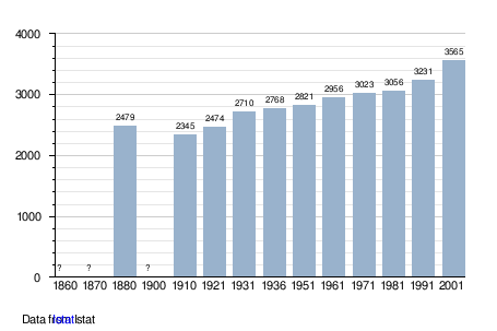
Demographic evolution
.png)
References
- "Superficie di Comuni Province e Regioni italiane al 9 ottobre 2011". Istat. Retrieved 16 March 2019.
- "Popolazione Residente al 1° Gennaio 2018". Istat. Retrieved 16 March 2019.
- All demographics and other statistics: Italian statistical institute Istat.
- "Heraldry of the World: Deutschofen". Archived from the original on 2012-08-01. Retrieved 2011-05-17.
- "Volkszählung 2011/Censimento della popolazione 2011". astat info. Provincial Statistics Institute of the Autonomous Province of South Tyrol (38): 6–7. June 2012. Retrieved 2012-06-14.
- Oscar Benvenuto (ed.): "South Tyrol in Figures 2008", Provincial Statistics Institute of the Autonomous Province of South Tyrol, Bozen/Bolzano 2007, p. 16, table 10
External links
![]()
- Obereggen Official Website
- (in German and Italian) Official website
| Authority control |
|
|---|