Main-Spessart
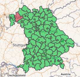
Main-Spessart is a Landkreis (district) in the northwest of Bavaria, Germany. It is located in Lower Franconia and derives its name from the river Main and the wooded hills of the Spessart.
Main-Spessart | |
|---|---|
| |
| Country | Germany |
| State | Bavaria |
| Adm. region | Lower Franconia |
| Capital | Karlstadt am Main |
| Area | |
| • Total | 1,322 km2 (510 sq mi) |
| Population (31 December 2018)[1] | |
| • Total | 126,365 |
| • Density | 96/km2 (250/sq mi) |
| Time zone | UTC+01:00 (CET) |
| • Summer (DST) | UTC+02:00 (CEST) |
| Vehicle registration | MSP |
| Website | http://www.main-spessart.de |
Geography
The district is bounded by (from the north and clockwise) the districts of Bad Kissingen, Schweinfurt and Würzburg, the state of Baden-Württemberg (district of Main-Tauber), the districts of Miltenberg and Aschaffenburg, and the state of Hesse (district of Main-Kinzig).
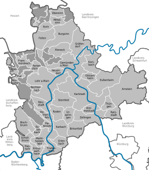
The river Main forms a large horse-shoe bend in the district, entering in the southeast near Thüngersheim and leaving to the southwest near Hasloch. In the north it is joined by the Franconian Saale river at Gemünden. The Spessart hills cover most of the area of the district west and north of the Main. To the northeast, the district borders on the Rhön hills.
History
The district was established in 1972 by merging the former districts of Gemünden, Karlstadt, Lohr and Marktheidenfeld. Although Lohr is the largest town, the seat of the administration is located in Karlstadt.
Economy
In 2017 (latest data available) the GDP per inhabitant was €36,264. This places the district 44th out of 96 districts (rural and urban) in Bavaria (overall average: €46,698).[2]
Coat of arms
 |
The coat of arms displays: |
Towns and municipalities
| Towns | Municipalities | |
|---|---|---|
References
- "Fortschreibung des Bevölkerungsstandes". Bayerisches Landesamt für Statistik und Datenverarbeitung (in German). July 2019.
- "VGR der Länder, Kreisergebnisse für Deutschland - Bruttoinlandsprodukt, Bruttowertschöpfung in den kreisfreien Städten und Landkreisen der Bundesrepublik Deutschland 2000 bis 2017 (German)". Statistische Ämter der Länder und des Bundes. Retrieved 4 February 2020.
External links
| Wikimedia Commons has media related to Landkreis Main-Spessart. |
- Official website (German)
| Authority control |
|
|---|