Weißenburg-Gunzenhausen
![]()
Weißenburg-Gunzenhausen | |
|---|---|
| |
| Country | Germany |
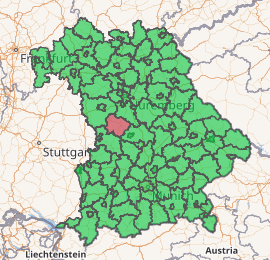
| State | Bavaria |
| Adm. region | Middle Franconia |
| Capital | Weißenburg |
| Area | |
| • Total | 970.83 km2 (374.84 sq mi) |
| Population (31 December 2018)[1] | |
| • Total | 94,393 |
| • Density | 97/km2 (250/sq mi) |
| Time zone | UTC+01:00 (CET) |
| • Summer (DST) | UTC+02:00 (CEST) |
| Vehicle registration | WUG |
| Website | landkreis-wug.de |
Geography
The district is located on the Hahnenkamm and on the Franconian Alb in the North of the Altmühltal. In the north there are several lakes of the Franconian Lake District. The highest point of the district is the Dürrenberg. The Altmühl flows through the district. From here comes the Solnhofen limestone. Among its nature reserves are the Brombachmoor.
History
The district was formed in 1972 by a merger of the districts of Gunzenhausen, Weißenburg, and the previously independent urban district of Weißenburg.
Coat of arms
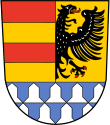 |
The coat of arms of the district is divided into three fields: left, right and bottom. The bottom of the coat of arms (silver kettle hats on blue) derives from the Counts of Pappenheim, and was taken from the coat of arms of the former district Weißenburg. The half eagle (black on yellow) in the right stands for the city of Weißenburg, and the red-yellow horizontal bars in the left are taken from the coat of arms of the former district Gunzenhausen. |
Towns and municipalities
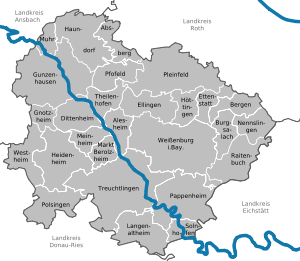
| Towns | Verwaltungsgemeinschaften | Municipalities |
|---|---|---|
|
¹ administrated inside a |
|
Sights
- Gelbe Burg, a mountain and site of an old hill castle.
- Ellinger Tor, a city gate in Weißenburg in Bayern.
- Wülzburg, a fortress.
- Bürgermeister-Müller-Museum in Solnhofen
- Ellingen Residence
- Fossa Carolina
References
- "Fortschreibung des Bevölkerungsstandes". Bayerisches Landesamt für Statistik und Datenverarbeitung (in German). July 2019.
External links
| Wikimedia Commons has media related to Landkreis Weißenburg-Gunzenhausen. |
- Official website (German)
Towns and municipalities in Weißenburg-Gunzenhausen | ||
|---|---|---|
| Authority control |
|
|---|