Karlstadt am Main
Karlstadt is a town in the Main-Spessart district in the Regierungsbezirk of Lower Franconia (Unterfranken) in Bavaria, Germany. It is the Main-Spessart district seat (Kreisstadt) and has a population of around 14,000.
Karlstadt am Main | |
|---|---|
 Old town of Karlstadt with the new building area at the Saupurzel in the background | |
 Coat of arms | |
Location of Karlstadt am Main within Main-Spessart district 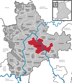 | |
 Karlstadt am Main  Karlstadt am Main | |
| Coordinates: 49°57′37″N 9°46′20″E | |
| Country | Germany |
| State | Bavaria |
| Admin. region | Unterfranken |
| District | Main-Spessart |
| Subdivisions | 9 Ortsteile |
| Government | |
| • Mayor | Paul Kruck (FW) |
| Area | |
| • Total | 98.11 km2 (37.88 sq mi) |
| Elevation | 163 m (535 ft) |
| Population (2018-12-31)[1] | |
| • Total | 15,004 |
| • Density | 150/km2 (400/sq mi) |
| Time zone | CET/CEST (UTC+1/+2) |
| Postal codes | 97753 |
| Dialling codes | 09353, 09359 (Rohrbach) |
| Vehicle registration | MSP |
| Website | www.karlstadt.de |
Geography
Location
The town lies roughly 25 km north of Würzburg in the Main-Franconian winegrowing region. While the town itself is located on the right bank of the Main river, the municipal territory extends to the left bank as well.
Constituent communities
Since the amalgamations in 1978, Karlstadt's Stadtteile have been Gambach, Heßlar, Karlburg, Klein Laudenbach, Laudenbach, Mühlbach, Rohrbach, Stadelhofen, Stetten and Wiesenfeld.
History
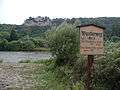
From the late 6th to the mid-13th century, the settlement of Karlburg with its monastery and harbor was located on the west bank of the Main. It grew up around the Karlsburg, a castle perched high over the community, that was destroyed in the Peasants' War in 1525. In 1202, Karlstadt itself was founded by Konrad von Querfurt, Bishop of Würzburg. The exact founding date is unknown. However, given that the founder's time in office was only four years (1198-1202), the time can be reckoned fairly easily.
The town was methodically laid out with a nearly rectangular plan to defend Würzburg territory against the Counts of Rieneck. The plan is still well preserved today. The streets in the old town are laid out much like a chessboard, but for military reasons they are not quite straight.
 Karlsburg, Karlstadt, on the west bank of the Main
 Main gate with flood gauge, Karlstadt
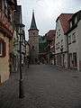 Main gate tower and main gate, Karlstadt
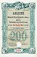 Bond of the town of Karlstadt am Main, issued 1 September 1888
In 1225, Karlstadt had its first documentary mention. In 1236, the castle and the village of Karlburg were destroyed in the Rieneck Feud. In 1244, winegrowing in Karlstadt was mentioned for the first time. From 1277 comes the earliest evidence of the town seal. In 1304, the town fortifications were finished. The parish of Karlstadt was first named in 1339. In 1369 a hospital was founded. Between 1370 and 1515, radical remodelling work was being done on the first, Romanesque parish church to turn it into a Gothic hall church. About 1400, Karlstadt became for a short time the seat of an episcopal mint. The former Oberamt of the Princely Electorate (Hochstift) of Würzburg was, after Secularization, in Bavaria's favour, passed in 1805 to Grand Duke Ferdinando III of Tuscany to form the Grand Duchy of Würzburg, and passed with this to the Kingdom of Bavaria.
The town's synagogue was destroyed on Kristallnacht (9 November 1938) by SA men, an event recalled by a plaque at the synagogue's former site.[2]
Governance
Mayor
The mayor of Karlstadt is Paul Kruck (Freie Wähler).
Town council
The council is made up of 24 council members, excluding the mayor.
| CSU | SPD | Grüne | FWG | Total | |
|---|---|---|---|---|---|
| 2002 | 10 | 7 | 2 | 5 | 24 seats |
| 2008 | 8 | 6 | 3 | 7 | 24 seats |
(as at municipal election held on 2 March 2008)
Coat of arms
The town's arms might be described thus: Quarterly, first and fourth azure, second and third argent a fleur-de-lis gules.
The town's earliest seal, from 1277, showed an effigy of Charlemagne, who is said to have founded and named the town (Charlemagne is called Karl der Große in German). The next seal after this one also bore Charlemagne's likeness, and this appeared on town seals until the 18th century. However, in 1544, the town began using a quartered shield as its arms. This is thought to have come from the banner of state borne by the Prince-Bishopric (Hochstift) of Würzburg, to which the town once belonged. The fleurs-de-lis were added in the early 19th century, and they refer to Charlemagne.[3]
Infrastructure
Transport
- Karlstadt lies at the junction of two Bundesstraßen, the B 26 and the B 27. On two road bridges, the Old Main Bridge (Alte Mainbrücke) built in 1953 and the more northerly New Main Bridge (Neue Mainbrücke) built in 2005, the river Main can be crossed.
- Through the municipal area runs the Hanover-Würzburg high-speed rail line, north-south. Within the municipal territory lie a section of the Mühlberg Tunnel and part of the Nantenbach Curve.
- Karlstadt has a small airfield east of the town.
Economy
Crafts and industry
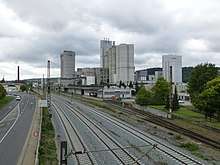
Local industry includes Düker Ironworks, the Schwenk Cement Works and the Kohl Wood Veneer Factory. Besides these three large industrial plants, many handicraft businesses have also set up shop in Karlstadt. Another big employer is the Main-Spessart Landratsamt (district administration). Many inhabitants commute to Würzburg, 25 km away, or Lohr am Main, 18 km away.
Winegrowing
Winegrowing has only a small economic importance nowadays but still has great cultural significance. Even if very few people in Karlstadt earn their livelihoods from winegrowing, it is still important for self-perception and the local way of life. Vineyards in Karlstadt are the Roßtal and Im Stein. There are also others in many of the outlying centres, especially in Stetten (Stettener Stein) and on the way from the main town out to Gambach.
Education
In 1999 the following institutions existed in Karlstadt:
- Kindergartens: 549 places with 548 children
- Primary schools: 5 with 63 teachers and 1,147 pupils
- Gymnasium: 1 with 60 teachers and 923 students
- Realschule with just under 600 students (in 2004)
- “Piranha” youth cultural centre: with some 1,000 visitors each year
Notable people
- Johannes Schöner (b. 16 January 1477, d. 16 January 1547 in Nuremberg), mathematician, geographer, cartographer, astronomer and astrologist
- Andreas Bodenstein (b. about 1482, d. 24 December 1541 in Basel), also named after his birthplace Karlstadt, or in Latinized form Carolstadius, reformer
- Johann Draconites (b. about 1494, d. 18 April 1566 in Wittenberg), theologian, humanistic philosopher and reformer
- Michael Beuther (b. 18 October 1522, d. 27 October 1587 in Strasbourg), historian, poet, jurist and official
- Johann Rudolph Glauber (b. 10 March 1604 in Karlstadt; d. 16 March 1670 in Amsterdam), apothecary and chemist
- Franz Sperr (b. 12 February 1878, d. 23 January 1945 executed in Berlin-Plötzensee), jurist and member of the Widerstand in the Third Reich
- Bernhard Fech (b. 1887, d. 1915 near Soldau in Masuria), painter
- Hermann Sendelbach (b. 1894 in Wiesenfeld-Erlenbach, d. 1971), writer, poet
- Detlef Wagenthaler (b. 1 August 1948 in Aschaffenburg, d. 23 September 2007 in Karlstadt), carnevalist
- Roland Büchner (b. 1954), Regensburg cathedral choirmaster, conductor, leader of the Regensburger Domspatzen
- Ruth Westheimer (b. 4 June 1928 im Wiesenfeld), sexual therapist, later U.S. citizen.
References
- "Fortschreibung des Bevölkerungsstandes". Bayerisches Landesamt für Statistik und Datenverarbeitung (in German). July 2019.
- Gedenkstätten für die Opfer des Nationalsozialismus. Eine Dokumentation, Band 1. Bundeszentrale für politische Bildung, Bonn 1995, ISBN 3-89331-208-0, S. 152
- Town’s armorial history at Heraldry of the World
External links
| Wikimedia Commons has media related to Karlstadt. |
- Town’s official webpage (in German)
- am Main Karlstadt am Main. article in: Meyers Konversations-Lexikon, 4. Aufl. 1888–1890, Bd. 9, S. 546 f.
| Authority control |
|
|---|