Møsvatn
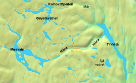
Møsvatn (or Møsvann) is tenth-largest lake in Norway with a surface area of 78.31 km2. It lies primarily Møsstrond, Vinje in Vestfold og Telemark. The lake lies in the watershed of the Skien river (Skiensvassdrag) and discharges into the Måna river. Along the shores of the lake, many traces of Stone Age settlers can be found. It is 919 meters above sea level and regulated to use for hydroelectric production. Some of Norway's highest mountain farms can be found here as well.
| Møsvatn | |
|---|---|
 Storfjorden on Møsvatn in direction west | |
 | |
| Location | Møsstrond, Vinje, Vestfold og Telemark |
| Coordinates | 59°52′N 8°05′E |
| Primary outflows | Via Måna through Vestfjorddalen and Rjukan down to Lake Tinn |
| Basin countries | Norway |
| Surface area | 78.31 km2 (30.24 sq mi) |
| Surface elevation | 919 m (3,015 ft) |
On 19 November 1942, as part of the efforts to sabotage German heavy water production, gliderborne troops were to land on the frozen lake Møsvatn near the Vemork hydroelectric plant, run by Norsk Hydro, near Rjukan. This effort was not successful; however ultimately the Norwegians stopped the heavy water production activities and helped limit the German nuclear weapons research program.
The museum and visitor's centre Hardangervidda Natursenter is located close to the lake. From Skinnarbu there is a boattrip with the MB Fjellvåken to Mogen.
See also
- Møsstrond