Luohu District
Luohu District is a district of Shenzhen located north of the New Territories of Hong Kong, east of Futian District, southeast of Longgang District, southwest of Pingshan District, and west of Yantian District. It is one of the oldest parts of the city, having represented Shenzhen as a fishing village before 1953 and a market town from 1953 to 1979, when Bao'an County was promoted to a prefecture-level city and renamed Shenzhen.[1][2][3]
Luohu 罗湖区 | |
|---|---|
 Luohu | |
| |
 Luohu District (the lower center, highlighted in purple) within Shenzhen | |
| Country | China |
| Province | Guangdong |
| Sub-provincial city | Shenzhen |
| Area | |
| • Total | 78.89 km2 (30.46 sq mi) |
| Population (2012) | 936,400 |
| Time zone | UTC+8 (China Standard) |
| Luohu District | |||||||||||||||||
|---|---|---|---|---|---|---|---|---|---|---|---|---|---|---|---|---|---|
| Simplified Chinese | 罗湖 | ||||||||||||||||
| Traditional Chinese | 羅湖 | ||||||||||||||||
| Literal meaning | Shell Lake (refers to a mountain) | ||||||||||||||||
| |||||||||||||||||
History
Prior to the establishment of Shenzhen Special Economic Zone(SEZ), an original town called Shenzhen (or Shum Chun) Hui (Chinese: 深圳墟; pinyin: Shenzhen market) was located within the current Luohu district. It was of size 350,000 m2 and has a population of little less than 30,000. The town centred at the present-day Dongmen, where a Tin Hau Temple once stood.
The name Shenzhen was first mentioned in 1410[4] though the town was only first documented in 1688[5] but was believed to be inhabited long before this. The market town prospered and expanded out of its boundaries in the early 20th century, following the completion of the Kowloon-Canton Railway, which the town was a stopping station. The town was occupied by Japanese forces between 1942 and 1945.It was promoted from market town to an official town status in 1950 .In 1953,the administrative centre of San On County was moved to Shum Chun from Nantou.
After Shenzhen was promoted to city status in October 1979,Luohu district was established as the first district in Shenzhen. Several small mountains were flattened to facilitate its infrastructure during initial construction phases. In November 1997, Yantian area became an independent administrative district.
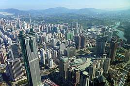
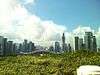
Some of the tallest and most recognizable buildings in Shenzhen, including Shun Hing Square, KK100 and the Guomao Building has are located within the district.
Geography
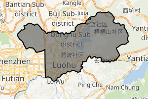
The size of Luohu district is about 78.9 km2 (30 sq mi) and contains 10 subdistricts.
Luohu is located in the southern part of Shenzhen, with Futian district on its west, Yantian district on its east, and Longgang district on its north. The Shenzhen River, which separates the district from North District, Hong Kong forms its southern limits.
It is also one of the six administrative districts of the Shenzhen Special Economic Zone (SEZ) of Shenzhen City of the People's Republic of China.
Luohu has an uneven geography and contains a number of natural fresh water sources, including Donghu (東湖/东湖), Honghu (洪湖), and Xianhu (仙湖), among others. Shuiku (水庫/水库), or "Water Reservoir", is also located in Luohu and is an important source of water for both Shenzhen and Hong Kong.
Shenzhen's highest peak, Wutong Mountain (944m) (梧桐山) is in Luohu District.
The district's west boundary with Futian is Hongling Road, and its east boundary with Yantian is Wutong Mountain.
Subdistricts
| Name | Chinese | Hanyu Pinyin | Canton Romanization | Population (2010)[6] | Area (km2) |
|---|---|---|---|---|---|
| Huangbei Subdistrict | 黄贝街道 | Huángbèi Jiēdào | wong4 bui3 gai1 dou6 | 113,382 | 7.50 |
| Guiyuan Subdistrict | 桂园街道 | Guìyuán Jiēdào | guei3 yun4 gai1 dou6 | 82,694 | 10.90 |
| Dongmen Subdistrict | 东门街道 | Dōngmén Jiēdào | dung1 mun4 gai1 dou6 | 90,454 | 2.10 |
| Cuizhu Subdistrict | 翠竹街道 | Cuìzhú Jiēdào | cêu3 zug1 gai1 dou6 | 110,459 | 3.45 |
| Dongxiao Subdistrict | 东晓街道 | Dōngxiǎo Jiēdào | dung1 hiu2 gai1 dou6 | 100,779 | 3.48 |
| Nanhu Subdistrict | 南湖街道 | Nánhú Jiēdào | nam4 wu4 gai1 dou6 | 90,500 | 2.63 |
| Sungang Subdistrict | 笋岗街道 | Sǔngǎng Jiēdào | sên2 gong1 gai1 dou6 | 64,004 | 4.03 |
| Donghu Subdistrict | 东湖街道 | Dōnghú Jiēdào | dung1 wu4 gai1 dou6 | 84,556 | 29.05 |
| Liantang Subdistrict | 莲塘街道 | Liántáng Jiēdào | lin4 tong4 gai1 dou6 | 85,569 | 13.10 |
| Qingshuihe Subdistrict | 清水河街道 | Qīngshuǐhé Jiēdào | qing1 sêu2 ho4 gai1 dou6 | 101,024 | 13.62 |
Immigration Control Point

Luohu serves as an important immigration control between Hong Kong and mainland China. Two immigration control points, Luohu and Man Kam To, are located in the Luohu district. The Luohu immigration point is the busiest land boundary patrol connecting Hong Kong and mainland China. It consists of the Luohu Port on the mainland side, and the Lo Wu Control Point on the Hong Kong side.
Entertainment
Shopping
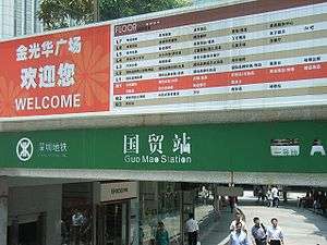
Luohu is known in Hong Kong and Guangdong for shopping. Most one-day visitors from Hong Kong limit their shopping to Luohu Commercial City (羅湖商業城/罗湖商业城), located right outside the Luohu Immigration Control Point, but the areas of Dongmen (東門/东门), Guomao (國貿/国贸), and Diwang (地王) are also important shopping districts.
Nightlife
Luohu district is also known for its nightlife. Though most expatriates residing in Shenzhen live in Shekou, visitors to Shenzhen from Hong Kong and other places typically frequent bars, KTV (karaoke) lounges, and night clubs in the Luohu area.
Education
Secondary Schools
As of the end of 2012,there are 221 educational institutions in Luohu District, amongst which 17 are secondary schools. Major secondary schools in include:
- Shenzhen Middle School
- Luohu Foreign languages School
- Cuiyuan Middle School
- Binhe Middle School
Transportation

Trunk roads
- Shennan East Road(深南東路/深南东路)
- Dongmen Road (東門路/东门路)
- Yanhe Road(沿河路) and Chunfeng Road Flyover (春風路高架橋/春风路高架桥)
- Nigang Road (泥崗路/泥岗路)
- Luosha Highway (羅沙公路/罗沙公路)
- Taoyuan Road
Buses and minibuses
Buses and minibuses serve as popular means of transportation modes in Luohu.
Shenzhen Railway
Shenzhen railway station (深圳火車站|深圳火车站) is located here. It serves as a terminal for train routes towards tens of cities in China.
Shenzhen Metro
Luohu is currently served by six metro lines operated by Shenzhen Metro:


See also
- List of tallest buildings in Shenzhen
- Lo Wu (Hong Kong part of the original town of Luohu/Lo Wu within the Frontier Closed Area)
References
- "CCTV.com-历史沿革". www.cctv.com. Retrieved 2018-12-27.
- 深圳概貌. Shenzhen People's Government. 12 July 2011. Archived from the original on 4 November 2011. Retrieved 26 December 2018.
- "CCTV.com-深圳历史沿革". www.cctv.com. Retrieved 2018-12-27.
- "Archived copy". Archived from the original on 2012-05-11. Retrieved 2015-08-04.CS1 maint: archived copy as title (link)
- "Archived copy". Archived from the original on 2015-06-04. Retrieved 2008-12-27.CS1 maint: archived copy as title (link)
- shi, Guo wu yuan ren kou pu cha ban gong; council, Guo jia tong ji ju ren kou he jiu ye tong ji si bian = Tabulation on the 2010 population census of the people's republic of China by township / compiled by Population census office under the state; population, Department of; statistics, employment statistics national bureau of (2012). Zhongguo 2010 nian ren kou pu cha fen xiang, zhen, jie dao zi liao (Di 1 ban. ed.). Beijing Shi: Zhongguo tong ji chu ban she. ISBN 978-7-5037-6660-2.
External links
External links
| Wikivoyage has a travel guide for Central Shenzhen. |
| Wikimedia Commons has media related to Luohu District. |
.svg.png)
Guangzhou (capital) | |||||||||||||||||||||||||||||||||||||||||||||||||||||||||||||||||||||
| Sub-provincial cities |
| ||||||||||||||||||||||||||||||||||||||||||||||||||||||||||||||||||||
| Prefecture-level cities |
| ||||||||||||||||||||||||||||||||||||||||||||||||||||||||||||||||||||
| |||||||||||||||||||||||||||||||||||||||||||||||||||||||||||||||||||||